|
|
|
|
|
|
|
|
|
|
|
|
|
|
|
|
|
Asia
|
|
|
|
|
363.
Asia and its islands according to d'Anville; divided into empires, kingdoms, states, regions, &ca. with the European possessions
and settlements in the East Indies and an exact delineation of all the discoveries made in the eastern parts by the English
under Captn. Cook. London: Robert Sayer: 1787 [6 January 1787].
|
1787. |
2 sheets.
Size: 102.2 x 242.5 cm.
Colored.
|
(400: 1787: D196ccv Large) |
|
364.
New and correct map of Asia laid down from the latest and best observations. [London]: R. Sayer: [ca. 1787].
Engraver:
W. Roads.
|
[ca. 1787]. |
Size: 56 x 48 cm.
Colored.
|
(400: [ca. 1787]: R537rsL Large) |
|
365.
A new and correct map of Asia, according to Sre d'Anville & other modern geographers. London: Robert Sayer: [ca. 1788].
|
[ca. 1788]. |
Scale: 69 British mi. = 1 degree.
Size: 58.3 x 101.7 cm.
Colored.
|
(400: [ca. 1788]: Sa97nca Large) |
|
366.
Asia. [1790].
|
[1790]. |
Size: 16.5 x 21.4 cm.
|
(032: En2) |
|
In: Thomas Dobson, publisher, Encyclopaedia, vol. 2, opposite p. 394.
Wheat: 863
Provenance:
Presented by Thomas Dobson, 1798.
|
|
|
367.
Asia, according to the best authorities. [London]: Woodman & Mutlow: [ca. 1790].
Engraver:
Mutlow.
|
[ca. 1790]. |
Size: 32.6 x 35.8 cm.
|
(400: [ca. 1790]: W859aba Small) |
|
Engraved for Chambers's edition of Guthrie's new system of geography.
The Transactions state that Carey presented the "Materials from which Guthrie's Geography were compiled." This is one of those maps. See:
William Guthrie, The general atlas for Carey's edition of his geography improved. Philadelphia: Carey: 1795 [1 May 1795].
Provenance:
Presented by Mathew Carey, 18 October 1805.
|
|
|
368.
Asia. Boston: Thomas & Andrews: [ca. 1793].
Engraver:
Amos Doolittle.
|
[ca. 1793]. |
Size: 16.3 x 21 cm.
|
(400: [ca. 1793]: D722asa Small) |
|
Engraved for Morse's American universal geography, vol. 1, opposite p. 384
Wheat: 873
|
|
|
369.
Asia from the latest authorities. [1798].
Engraver:
Rollinson.
|
[1798]. |
Size: 18.7 x 22.1 cm.
|
(910: P29) |
|
In: John Payne, A new and complete system of universal geography, vol. 1, opposite p. 3.
Wheat: 903
|
|
|
370.
Asia and its islands according to d'Anville; divided into empires, kingdoms, states, regions &ca, with the European possessions
and settlements in the East Indies and an exact delineation of all the discoveries made in the eastern parts by the English
under capts. Cook, Vancouver & Peyrouse. London: Laurie & Whittle: 1799 [2 February 1799].
|
2 February 1799. |
Size: 102.7 x 120 cm.
Colored.
|
(400: 1799: As41adc Large) |
|
Near East
|
|
|
|
|
371.
Carte comprenant le pays de Nedjd ou Arabie Centrale, l'Égypte et partie des autres régions occupées en 1820, par les troupes
de Mohammed-Aly, pour servir à l'intelligence de l'histoire de l'Égypte sous le gouvernement de Mohammed-Aly. Par M. E. J[omard] D. L. Paris: 1823.
Cartographer:
Edmé François Jomard.
|
1823. |
Scale: 1:4,000,000.
Size: 42.5 x 54.3 cm.
|
(415.4: 1823: J69ara Small) |
|
Inset: Environs d'el Derréyeh.
|
|
|
372.
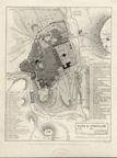
Plan of Jerusalem by F. Catherwood, Architect, July, 1835. London: author: 1835.
Cartographer:
F. Catherwood.
Engraver:
S. Bellin.
|
1835. |
Scale: 2½ in. = 1,500 feet.
Size: 26.8 x 21.2 cm.
|
(414.944: 1835: C282jer Small) |
|
See "F. Catherwood architect," (in New-York Historical Society Quarterly, vol. 30, no. 1.)
|
|
|
373.
Map of Mr. Southgate's route through Turkey and Persia: chiefly from original observations. [New York: ca. 1850].
Engraver:
Sherman & Smith, New York.
|
[ca. 1850]. |
Scale: 69.1 English mi. = 1 degree.
Size: 32 x 82.3 cm.
|
(411: [ca. 1850]: So87tu Large) |
|
374.
Vestiges of Assyria [in three sheets] . . . Ninevah . . . Nimrúd and Selamiyeh . . . [and] River Tigris & the upper Zab .
. . constructed from a trigonometrical survey in the spring of 1852 at the command of the government of India by Felix Jones
. . . [and] J. M. Hyslop. [Baghdad]: John Walker: 1855. 3 maps.
Cartographer:
Felix Jones and J.M. Hyslop.
Engraver:
J. & C. Walker.
|
1855. |
Scale: 1760 yd. = 1 English statute mi.
Size: 122.8 x 69 cm.; 123 x 69 cm.; 123 x 69 cm.; 123.2 x 69.1 cm.
Colored.
|
(417: 1855: J714nnt Large) |
|
375.
A map of Turkestan to illustrate the travels of Arminius Vambéry in 1863. New York: Harper: [1863].
|
[1863]. |
Scale: 1 in. = 40 English statute mi.
Size: 36.7 x 64. cm.
Colored.
|
(421: [1863]: T848avt Large) |
|
376.
Distribution of tribes in Iraq. Map A. N.p.: [ca. 1939].
Cartographer:
Richard A. Martin.
|
[ca. 1939]. |
Scale: 1:2,000,000.
Size: 41 x 52.1 cm.
|
(417: [ca. 1939]: M365tri Small) |
|
To accompany: "The anthropology of Iraq," by Henry Field. Field Museum of Natural History. Anthropological series, vol. 30.
|
|
|
377.
Distribution of tribes in western Iran. Map B. N.p.: [ca. 1939].
Cartographer:
Peter Gerhard.
|
[ca.1939]. |
Scale: 1:2,000,000.
Size: 52 x 41.2 cm.
|
(418:[ca. 1939]: G322tri Small) |
|
To accompany: "Contributions to the anthropology of Iran," by Henry Field. Field Museum of Natural History Anthropological
series, vol. 29, 1939.
|
|
|
Far East
|
|
|
|
|
378.
Ostium fluvii Amur cum parte australiori terrae Kamtschatkae variisque in oceano sitis insulis inter quas pars eminet Iaponiae. N.p.: [ca. 1795].
|
[ca. 1795]. |
Scale: 3 cm. = 100 russticorum.
Size: 51.2 x 56.8 cm.
|
(425.2: [1795]: Am11ofa Large) |
|
379.
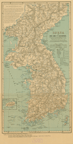
Map of Korea and Manchuria prepared by the Second Division, General Staff (Military Information Division) War Department. Washington: Norris-Peters: 1904.
|
1904. |
Scale: 1:2,534,400.
Size: 99.8 x 85.7 cm.
Colored.
|
(405: 1904: Un38kmc Large) |
|
Inset: Index map of East Asia.
|
|
|
380.
Large print map of the Far East. Produced under the direction of Alexander Gross, F.R.G.S. New York: n.d.
Cartographer:
Alexander Gross.
|
n.d. |
Scale: 2 in. = 300 mi.
Size: 97.2 x 134.5 cM.
Colored.
|
(405: n.d.: G922fea Large) |
|
Inset: Indian Ocean; Korea; Korea and Saishu; the Pacific Ocean basin; Formosa.
Provenance:
Presented by Mrs. A. I. Hallowell, November 1983.
|
|
|
Japan
|
|
|
|
|
381.
Korea or Cho-sen of the Japanese. Compiled from the map published by the Japanese War Ministry, Tôkiô, in 1875, and from the latest coast surveys. Names transliterated
by Dr. Ernest Satow. Washington: Norris Peters Co.: [ca. 1895].
Cartographer:
Charles H. Ourand.
|
[ca. 1895]. |
Scale: 1:1,700,000.
Size: 53.1 x 28 cm.
Colored.
|
(433: [ca. 1895]: K844tok Small) |
|
Inset: Quelpart I[slan]d Ché-Ju of the Koreans.
|
|
|
382.
Topographical map of the Japanese Empire. Imperial Geological Survey of Japan. 1899. Tokyo: G. Yoshii: 1899.
Cartographer:
T. Togawa and K. Suzuki.
Engraver:
N. Matsudaira.
|
1899. |
13 sheets.
Scale: 1:1,000,000.
Size: Various sizes.
Colored.
|
(430: 1899:J274top Small) |
|
See: Geological Survey of Japan, Outlines of the geology of Japan. 1902.
|
|
|
383.
General map [of Japan] showing the distribution of volcanoes. Imperial Geological Survey of Japan. [Tokyo: ca. 1902].
|
[ca. 1902]. |
2 sheets.
Scale: 1:5,000,000.
Size: 33.1 x 50.6 cm.
|
(430: [ca. 1902]: J274vol Small) |
|
See: Geological Survey of Japan, Outlines of the geology of Japan. 1902.
|
|
|
384.
Geological map of the Japanese Empire . . . compiled by the Imperial Geological Survey of Japan. Tokyo: G. Yoshii: 1902.
Cartographer:
T. Togawa, E. Tamura, and K. Suziki.
Engraver:
N. Matsudaira.
|
1902. |
12 sheets.
Scale: 1:1,000,000.
Size of paper: ca. 41 x 57.5 cm. each.
Colored.
|
(430: 1902: J274geo Small) |
|
See: Geological Survey of Japan, Outlines of the geology of Japan. 1902.
|
|
|
385.
Hypsometrical and bathymetrical chart [of Japan]. Imperial Geological Survey of Japan. [Tokyo: ca. 1902].
|
[ca. 1902]. |
2 sheets.
Scale: 1:5,000,000.
Size: 33.2 x 50.6 cm., and, 37 x 50.6 cm.
Colored.
|
(430: [ca. 1902]: J274voL Small) |
|
See: Geological Survey of Japan, Outlines of the geology of Japan. 1902.
|
|
|
386.
Political division of the Japanese Empire. Imperial Geological Survey of Japan. Tokyo: [ca. 1902].
|
[ca. 1902]. |
Scale: 1:10,000,000.
Size: 38 x 50.5 cm.
Colored.
|
(430: [ca. 1902]: J274voL Small) |
|
See: Geological Survey of Japan, Outlines of the geology of Japan.
|
|
|
China
|
|
|
|
|
386a.
Carte de la Chine dressée pour servir au voyage de l'ambassade de la Compagnie des Indes Hollandaises vers l'empéreur de la
Chine, dans les années 1794 & 1795 [1797].
Engraver:
Vallance.
|
[1797]. |
Scale: 2.5 cm. = 30 mi.
Size: 105.9 x 53 cm.
|
(915. 1: B72) |
|
In: Andreas Everard van Braam Houckgeest, Voyage de l'Ambassade, vol. l, opposite p. XLIX.
Wheat: 892
Provenance:
Presented by John Vaughan, 15 March 1839.
|
|
|
387.
Plan de la ville de Macao à la Chine possédée par les Portugais. 1795 [1798].
Engraver:
Vallance.
|
[1798]. |
Scale: [2.5 cm. = ca. 4,500 ft.].
Size: 17.3 x 36 cm.
|
(915.1: B72) |
|
In: Andreas Everard van Braam Houckgeest, Voyage de l'Ambassade, vol. 2, opposite p. 219.
Wheat: 896
Provenance:
Presented by John Vaughan, 15 March 1839.
|
|
|
388.
[Chinese maps of Canton and Hong Kong, China. Ca. 1820].
|
[ca. 1820]. |
Size of paper: 57.2 x 34.4 cm. Canton: 21.8 x 28.2 cm., and Hong Kong: 19.5 x 37.5 cm.
Colored.
|
(443: [ca. 1820]: C162kwa Small) |
|
Provenance:
Presented by Joshua L. Oakford, 8 November 1820.
|
|
|
389.
Bartholomew's special map of China, Japan, and Korea. The Edinburgh Geographical Institute. Edinburgh: John Bartholomew & co.: [ca. 1900].
|
[ca. 1900]. |
Scale: 1 in. = 11¾ mi.
Size: 52.3 x 85.7 cm.
Colored.
|
(405: [ca. 1900]: B231cjk Large) |
|
Insets: Asia, Hong Kong, and Canton areas; Korea to Viet Nam coastal regions; Tokio Bay; Peking; Peking to Ta-Ku area showing railroads
and proposed railroads.
|
|
|
390.
Map of Kwantung peninsula prepared in the Second Division, General Staff, War Department, July, 1904. Washington: Andrew B. Graham: 1904.
|
1904. |
Scale: 2 cm. = 1 mi.
Size: 56.2 x 82 cm.
Colored.
|
(441: 1904: Un38kwp Large) |
|
391.
A commercial map of China and its dependencies, showing the areas owned or leased by foreign powers. Issued by the China League. London: Edward Stanford: [ca. 1910].
|
[ca. 1910]. |
Scale: 120 mi. = 1 in.
Size: 55.3 x 78.4 cm.
Colored.
|
(440: [ca. 1910]: C342ccf Large) |
|
392.
[China]. N.p.:n.d., ca. [1919].
|
[ca. 1919]. |
Size: 69.5 x 86.8 cm.
|
(441: [ca. 1919]: C442chi Large) |
|
393.
General map of China and adjacent regions, showing treaty ports and railways. Prepared for the Department of State by the Topographic Branch, U.S. Geological Survey, 1921. Revised Jan. 1922. Lambert
conformal conic projection. [Washington]: 1922.
|
1922. |
Scale: 1:10,000,000.
Size: 50.1 x 63.7 cm.
Colored.
|
(441: 1922: Un38ctp Large) |
|
394.
China. Showing mission stations except the Roman Catholic. Compiled by S. W. Boggs and R. Beach. New York: Missionary Education
Movement of the U.S. and Canada: 1924.
Cartographer:
S. W. Boggs and R. Beach.
|
1924. |
Scale: 1:3,250,000.
Size: 91.2 x 116.3 cm.
Colored.
|
(441: 1924: C442ms Large) |
|
Inset: China provinces, special administrative districts, and outer territories.
Provenance:
Presented by the Rockefeller Institute and James Thomas Flexner, 1964. Contains an index of mission stations.
|
|
|
395.
General geological map of China. V.K. Ting and W.H. Wong, directors of the Geological Survey of China. Compiled in 1924. N.p.: 1926. Sheet N J-19.
Cartographer:
J. F. Na, C.C. Wang, Frank A. Herald, F. G. Clapp, M.L. Fuller, E. L. Estabrook, C. Li, Bailey Willis, V. K. Ting, and E.
T. Nyström.
|
1926. |
Scale: 1:1,000,000.
Size: 47 x 57 cm.
Colored.
|
(441: 1926: C442gmc Large) |
|
396.
[Peking, China]. N.p.: n. d.
|
n.d. |
Size of paper: 95 x 54.6 cm.
Colored.
|
(444.962: n.d.: P366cmp Large) |
|
397.
[China]. N.p.: n.d.
|
n.d. |
Size of paper: 120.5 x 73.4 cm.
Colored.
|
(441: n.d.: C342cmc Large) |
|
Inset: Two, of groups of islands.
Provenance:
Presented by Joshua L. Oakford, 8 November 1820.
|
|
|
398.
[China]. N.p.: n.d.
|
n.d. |
Size of paper: 115 x 55 cm.
|
(441: n.d.: C342mce Large) |
|
India
|
|
|
|
|
399.
A map of Bengal, Bahar, Oude & Allahabad with part of Agra and Delhi. Exhibiting the course of the Ganges from Hurdwar to the sea. By James Rennell. London: Wm. Faden: 1786 [1 January 1786].
Cartographer:
James Rennell.
|
1 January 1786. |
Scale: 2 in. = 40 British mi.
Size: 70.8 x ca. 106.5 cm.
Colored.
|
(455: 1786: R295bba Large) |
|
400.
An accurate map of Hindostan or India, from the best authorities, N.p.: Woodman & Mutlow: [ca. 1790].
Engraver:
John Mutlow.
|
[ca. 1790]. |
Scale: 69½ British mi. = 1 degree.
Size: 39.5 x 41.6 cm.
|
(450: [ca. 1790]: W859hin Small) |
|
The Transactions (vol. 6) state that Carey presented the "Materials from which Guthrie's Geography were compiled." This is one of those maps.
See: William Guthrie, The general atlas for Carey's edition of his geography improved. Philadelphia: Carey: 1790 [1 May 1790].
Provenance:
Presented by Mathew Carey, 18 October 1805.
|
|
|
401.
The southern countries of India from Madras to Cape Comorin, describing Colonels Fullarton and Humberston during the campaigns
of 1782, 1783, & 1784. Surveyed by Col. Kelly, Capt. Wersebe, and others. London: Wm. Faden: 1791 [8 February 1791].
Cartographer:
Col. Kelly and Capt. Wersebe.
|
8 February 1791. |
Scale: 69½ British statute mi. = 1 degree.
Size: 87.3 x ca. 105 cm.
Colored.
|
(456: 1791: K288mcc Large) |
|
Indochina
|
|
|
|
|
402.
Carte archéologique de la région d'Ankor. D'après les travaux de l'École Française d'Extrême-Orient de l'Aviation Militaire et du Service Géographique. Héliograve
et imprimé par le Service Géographique de l'lndochine: 1939.
|
1939. |
Scale: 1:40,000.
Size: 56.7 x 87.1 cm.
Colored.
|
(461:1939: In244 Large) |
|
403.
Carte ethnolinguistique. Carte de l'lndochine. Dressé sous la direction de l'École Française d'Extrême-Orient. Dessiné et publié par le Service Géographique
de l'lndochine: 1949.
|
1949. |
Scale: 1:2,000,000.
Size: 84.1 x 60.2 cm.
Colored.
|
(460: 1949: In243 Large) |
|
Has key to languages.
|
|
|
Indonesia
|
|
|
|
|
404.
The East Indies, with the roads. By Thomas Jefferys. [London]: 1768.
Cartographer:
Thomas Jefferys.
|
1768. |
2 sheets.
Size: 108 x 274 cm.
Colored.
|
(470: l768:J377rds Large) |
|
405.
East Indies. [1793].
Engraver:
S. Alardice.
|
[1793]. |
Scale: 60 mi. = 1 degree.
Size: 17.2 x 27.5 cm.
|
(032: En2) |
|
In: Thomas Dobson, publisher, Encyclopaedia, vol. 9, opposite p. 218.
Wheat: 871
Provenance:
Presented by Thomas Dobson, 1798.
|
|
|
406.
Chart of the new discoveries east of New Holland and New Guinea. 1797.
Engraver:
Callender.
|
1797. |
Size: 16.7 x 24.4 cm.
|
(917.3: M83am) |
|
In: Jedidiah Morse, The American gazetteer, opposite 'Terra Austral."
Wheat: 911
|
|
|
407.
East Indies from the best authorities. [1798].
Engraver:
Rollinson.
|
[1798]. |
Scale: 2.5 cm. = 600 American statute mi.
Size: 18.6 x 26.4 cm.
|
(910: P29) |
|
In: John Payne, A new and complete system of universal geography, vol. 1, opposite p. 312.
Wheat: 913
|
|
|
The Philippine Islands
|
|
|
|
|
408.
Plano de la bahia de Nin y puerto de Mandao, situado en la costa ocidental de la Ysla de Masbate; levantado en 1828 por .
. . D. Federico Vargas y publicado en la Dirección de Hidrografia. Madrid: 1850.
Cartographer:
Federico Vargas and F. Bregante.
Engraver:
J. Noguera.
|
1850. |
Scale: Scale of 1 nautical mi. divided in 1/ 10s.
Size: 29.8 x 45.7 cm.
|
(482: 1850: Sp27ppb Large) |
|
On same sheet is: Plano de puerto de Baton. . .
Provenance:
Presented by the director of the Dirección de Hidrografla in Madrid through the hands of Don Severiano Moreledo,
of Cadiz, 7 January 1853.
|
|
|
409.
Plano del puerto de Batan situado en la costa W. de Panay, levantado en 1842 por... Comisión Hidrográfica. Madrid: 1850.
Engraver:
Noguera.
|
1850. |
Scale: Scale of 1 nautical mi. divided in 1/10s.
Size: 34.2 x 45.7 cm.
|
(482: 1850: Sp27ppb Large) |
|
On same sheet is: Plano de la bahia de Nin . . .
Provenance:
Presented by the director of the Dirección de Hidrografia in Madrid through the hands of Don Severiano Moreledo,
of Cadiz, 7 January 1853.
|
|
|
410.
Plano del puerto de Busainga, situado en la parte n. e. de la isla de Burias; levantado en 1841 por . . . la Comisión Hidrográfica.
Madrid: 1850.
Cartographer:
F. Bregante.
Engraver:
J. Noguera and F. Bregante.
|
1850. |
Scale: Scale of ½ nautical mi. divided in l/10s.
Size: 32.2 x 46 cm.
|
(482: 1850: Sp27ppL Large) |
|
On the same sheet is: Plano del puerto de Laguimanor . . .
Provenance:
Presented by the director of the Dirección de Hidrografia in Madrid through the hands of Don Severiano Moreledo,
of Cadiz, 7 January 1853.
|
|
|
411.
Plano del puerto de Laguimanor situado en la costa s. de la isla de Luzon, levantado en 1841 por el comandante . . . de la
Comisión Hidrográfica, en el Archipiélago Filipino. Madrid: 1850.
Cartographer:
F. Bregante.
Engraver:
J. Noguera and F. Bregante.
|
1850. |
Scale: Scale of ½ nautical mi. divided in 1/10s.
Size: 32 x 46 cm.
|
(482: 1850: Sp27ppL Large) |
|
On same sheet is: Plano del puerto de Busainga . . .
Provenance:
Presented by the director of the Dirección de Hidrografia in Madrid through the hands of Don Severiano Moreledo,
of Cadiz, 7 January 1853.
|
|
|
412.
Plano del puerto de Zebú, levantado por el comandante y oficiales de la Comisión Hidrográfica en el archipiélago Filipino
. . . Madrid: 1850.
Cartographer:
F. Bregante.
|
1850. |
Scale: 11.5 cm. = 2 nautical mi.
Size: 46 x 63.9 cm.
|
(482: 1850: Sp27ppzf Large) |
|
413.
Isla de Panay bosquejo geológico por D. Enrique Abella y Casariego. Manila: Carmelo y Bauermann: [1890]. Map in 2 pieces.
Cartographer:
Enrique Abella y Casariego.
|
[1890]. |
Scale: 1:200,000.
Size: 99.7 x 76.4 cm.
Colored.
|
(484: [1890]: Abllpan Large) |
|
See Enrique Abella y Casariego, Descripción fisica, geológica y mineria en la isla de Panay. Manila: 1920.
|
|
|
414.
[Maps of the Philippine Islands belonging to the Bulletins of the Division of Geology and Mines, Philippine Islands] 3-5. Manila: 1890-1903.
|
1890-1905. |
11 maps.
Scale: various.
Size: various.
Colored.
|
(480: 1890-1905: P536mgd Large) |
|
See Philippine Islands. Mining Bureau. Annual report.
|
|
|
415.
[Map of the Philippine Islands, chiefly from Spanish surveys]. Washington: Hydrographic Office: 1898.
Engraver:
Julius Bien & Co.
|
1898. |
Size: 260 x 126 cm.
Colored.
|
(484: 1898: Un36ppa Large) |
|
This is a composite of several maps.
|
|
|
416.
Carta general (en dos hojas) del Archipiélago Filipino levantada principalmente por la Comisión Hidrografia. [Por] Claudio
Montero y Gay . . . 1870 . . . 1875 . . . Issued by the War Department, Adjutant General's Office, Military Information Division,
1900. Second ed. [Washington]: 1900.
Cartographer:
Claudio Montero y Gay and J. Noguera.
Engraver:
J. Noguera.
|
1900. |
Size: 127 x 96 cm.
Colored.
|
(480: 1900: Sp27cga Large) |
|
417.
Map of the Viscayan Group Philippine Islands including Panay, Negros, Samar, Leyte, Cebu, Mosbate, Bohol and adjacent islands. Prepared in the War Department, Adjutant General's Office. Military Information Division. 1900. [Washington]: Julius Bien
& Co.: 1900.
Cartographer:
C. H. Stone.
Engraver:
C. H. Ourand and E. M. Eastwood.
|
1900. |
Scale: 1 cm. = 5 km.
Size: 83.2 x 96.6 cm.
Colored.
|
(484: 1900: Un38vgp Large) |
|
418.
Map of the Philippines prepared in the Bureau of Insular Affairs, War Department. Washington: Andrew B. Graham: 1902.
Engraver:
Andrew B. Graham.
|
1902. |
Scale: 1 in. = 18 statute mi.
Size: 166.3 x 106.3 cm.
Colored.
|
(484: 1902: Un38bia Large) |
|
Inset: Manila.
|
|
|
419.
Map of the Philippine Islands compiled from the latest official data in the Military Information Division, Adjutant General's
Office, War Department, Washington, U.S.A. 1903. [Washington]: 1903.
|
1903. |
4 pieces.
Scale: 2 cm. = 10 mi.
Size: 239.3 x 156 cm.
Colored.
|
(484: 1903: Un38mdp Large) |
|
Inset: Manila.
|
|
|
420.
Geologic reconnaissance map of Mindanao. U.S. Bureau of Science, Division of Mines. Based on U.S. Coast and Geodetic chart. [1912].
Cartographer:
Warren D. Smith, geologist.
Engraver:
A. Moskaira.
|
[1912]. |
Size: 54 x 59 cm.
Colored.
|
(486: [1912]: P536rec Small) |