|
|
|
|
|
|
|
|
|
|
|
|
|
|
|
|
|
The World
|
|
|
|
|
62.
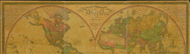
Universalior cogniti orbis tabula ex recentibus confecta observationibus. Published for Cl. Ptolomaei Geographia. Rome: 1508.
|
1508. |
Size: 40.6 x 54.1 cm.
|
(100: 1508: P956rom Large) |
|
Facsimile. Contains facsimile autograph of John Farden.
|
|
|
63.
Nova & accuratissima totius terrarum orbis tabula nautica variationum magneticarum index juxta observationes anno 1700. Habitas
constructa per Edm. Halley. 1700. London: Vincent Brookes, Day & Son, 1870.
Cartographer:
Edmund Halley.
|
1700. |
Size: 48 x 114.6 cm. [The size of the copy in the British Museum is 48 x 201/2 in.]
|
(100: 1700: H143ter Large) |
|
Contains autograph of G. B. Airy.
Reproduced by photolithography, September 1870, with the permission of the Principal Librarian of the British Museum, from
the copy (presumed to be of the original edition) preserved in the Library of the Museum.
Provenance:
Presented by Greenwich Observatory, 6 October 1871.
|
|
|
64.
Mappe-monde divisée en ses quatre parties. N.p. 1759.
|
1759. |
Size: 15.6 x 30 cm.
|
(100: 1759: M325gbe Small) |
|
65.
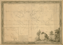
Carte des parties principales du globe terrestre pour servir à l'histoire des deux premiers siècles depuis la création du
monde. Dediée à Monseig[neu]r le Comte de Saint Florentin, ministre & secrétaire d'état, Commandeur des Ordres du Roy. Par
Monsieur Luneau de Boisjermain. Paris: 1765.
Cartographer:
H. Gravelot.
Engraver:
Jac. Charpentier.
|
1765. |
Size: 59.8 x 82.3 cm.
|
(100: 1765: L965ter Large) |
|
Inset: Supplement à la carte du Paradis Terrestre.
"Premier feuille."
|
|
|
66.
Chart of the world, according to Mercator's projection, shewing the latest discoveries of Capt. Cook. London: C. Dilly and G. Robinson: 1785. 15 June 1785.
|
15 June 1785. |
Size: 37.2 x 48.6 cm.
Colored.
|
(100: 1785: D582mer Large) |
|
Engraved for Guthrie's new system of geography.
Contains manuscript notations for use in Carey's edition. The Transactions (Vol. 6) state that Carey presented the "Materials from which Guthrie's Geography were compiled." This is one of those maps.
See: William Guthrie, The general atlas for Carey's edition of his geography improved. Philadelphia: Carey: 1795 [1 May 1795] (912.G98c).
Provenance:
Presented by Mathew Carey, 18 October 1805.
|
|
|
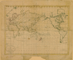
67.
A map of the world from the best authorities. London: C. Dilly & G. Robinson: 1785.
|
1785. |
Size of plate: 30 x 54 cm.
Colored.
|
(100: 1785: D582wor Small) |
|
Engraved for William Guthrie. Atlas to his system of geography . . . London: Dilly: 1785.
Shows tracks of James Cook's voyages.
The Transactions (Vol. 6) state that Carey presented the "Materials from which Guthrie's Geography were compiled." This is one of those maps.
See: William Guthrie, The general atlas for Carey's edition of his geography improved. Philadelphia: Carey: 1795 [1 May 1795].
Provenance:
Presented by Mathew Carey, 18 October 1805.
|
|
|
68.
[Map of the world in two hemispheres]. Western, New World Hemisphere; and, Eastern, Old World Hemisphere. London: William Faden: 1786 [28 October 1786].
Cartographer:
William Faden.
Engraver:
William Faden.
|
28 October 1786. |
Size of plate: 36.7 x 73 cm.
Colored.
|
(120: 1786: F121weh Large) |
|
69.
A new general chart of the world, exhibiting the whole of the discoveries made by the late Capt. James Cook, F.R.S. with the
track of the ships under his command. Also those of Capt. Phipps (now Lord Mulgrave) in his expedition to the North Pole. London: Wm. Faden: 1787 [1 January 1787].
Cartographer:
William Faden.
|
1 January 1787. |
Size: 41.7 x 57 cm.
Colored.
|
(100: 1787: F121ccv Large) |
|
70.
A map of the world, drawn & engraved from d'Anville's two sheet map, with improvements for I. Harrison No. 115, Newgate Street. [London]: I. Harrison: 1788. 1 December 1788.
Engraver:
Neele.
|
1 December 1788. |
Size of paper: 47.6 x 78 cm.
Colored.
|
(100: 1788: H243amw Large) |
|
In two hemispheres.
|
|
|
71.
[Two designs for projecting the map of the world. 1789].
Engraver:
Eliza Colles.
|
[1789]. |
Size of plate: 18.8 x 27.1 cm.
|
(Pam., vol. 349, no. 4) |
|
In: Christoper Colles. The geographical ledger and systematized atlas.
|
|
|
72.
Carte magnétique des deux hemisphères. N.p.: [ca. 1790].
|
[ca. 1790]. |
Size: 48.2 x 93.3 cm.
|
(100: [ca. 1790]: C242cmh Large) |
|
"No. 8."
|
|
|
73.
A chart of the world, according to Mercators projection; shewing the latest discoveries of Capt. Cook. London: [ca. 1790].
Engraver:
Woodman & Mutlow.
|
[ca. 1790]. |
Size: 36.4 x 47.2 cm.
|
(100: [ca. 1790]: W859ccv Large) |
|
Showing the tracks of the Endeavour and the Resolution. Engraved for Chambers's edition of Guthrie's new system of geography.
The Transactions (Vol. 6) state that Carey presented the "Materials from which Guthrie's Geography were compiled." This is one of those maps.
See: William Guthrie, The general atlas for Carey's edition of his geography improved. Philadelphia: Carey: 1795 [1 May 1795].
Provenance:
Presented by Mathew Carey, 18 October 1805.
|
|
|
74.
To George Washington president of the United States of America this magnetic atlas or variation chart is humbly inscribed
by John Churchman. Philadelphia: James Johnson: 1790. First edition. Trimmed.
Cartographer:
John Churchman.
|
1790. |
Size of paper: 60.6 x 62.4 cm.
Colored.
|
(100: 1790: C492mag Large) |
|
In: Pam. 538.7:C47e. John Churchman, An explanation of the magnetic atlas or variation chart. Philadelphia: James Johnson: 1790. Front.
Churchman was an American who was devoted to his own theories of the variations of the magnetic needle and other things. He
had presented his scheme to the Society in 1787 and was given mild encouragement. He founded his belief on the
hypothesis of two bodies (besides the moon) revolving round the earth, in small circles parallel to the equator; one near
the north pole, and the other was near the south pole; and the needle, being wholly governed by the attraction of these magnetic
satellites, will, in whatever part of the world, always rest in the plane of the circle, passing through them and the given
place. [The American Museum, Sept. 1789: p. 218].
He persevered in his work and at the 17 September 1790 meeting his "Navigation Chart, or Magnetick Atlas" was presented. It
disappeared, but another copy was given by Johann Rodolph Valltravers on 19 May 1797. The Valltravers copy is the one now
at the Society.
Wheat: 6
Provenance:
Presented by the author to the Society, 17 September 1790, with a description. Another copy presented by Johann R.
Valltravers, 19 May 1797.
|
|
|
74a.
Dialing. A "Universal Dial" incorporating a "terrestrial globe," indicates Africa, Europe, Asia, and America on the globe.
[1792].
Engraver:
Scot.
|
[1792]. |
Scale: Diameter of the sphere = 2.8 cm.
Size: 27 x 20.6 cm.
|
(032: En2) |
|
In: Thomas Dobson, publisher, Encyclopaedia, vol. 5, opposite p. 792.
Wheat: 15
Provenance:
Presented by Thomas Dobson, 1798.
|
|
|
74b.
Geography. Map of the world, comprehending the latest discoveries. Captain Cook's last voyage is shown with his Alaskan discoveries.
Zaara or The Desert appears for the Sahara in Africa. [1792].
|
[1792]. |
Scale: Diameter of sphere, 17.4 cm.
Size: 19.6 x 35.5 cm.
|
(032: En2) |
|
In: Thomas Dobson, publisher, Encyclopaedia, vol. 7, following page 662.
Wheat: 16
Provenance:
Presented by Thomas Dobson, 1798.
|
|
|
74c.
Geography. A map of the world in three sections, describing the polar regions to the tropics in which are traced the tracts
of Lord Musgrave and Captain Cook towards the North and South Poles and the torrid zone or tropical regions with the new discoveries
in the South Sea. [North and south hemispheres and a belt map of the tropical regions]. [1792].
Engraver:
W. Barker.
|
[1792]. |
Size of plate: 23.5 x 43.5 cm.
|
(032: En2) |
|
In: Thomas Dobson, publisher, Encyclopaedia, vol. 7, following p. 662.
Wheat: 17
Provenance:
Presented by Thomas Dobson, 1798.
|
|
|
74d.
Geography. [With six diagrams, four of which show portions of the earth's surface. All the continents are shown on one or more of the
hemispheres. California is shown as an island]. [1792].
|
[1792]. |
Size of plate: 23.7 x 17.5 cm.
|
(032: En2) |
|
In: Thomas Dobson, publisher, Encyclopaedia, vol. 7, opposite p. 650.
Wheat: 14
Provenance:
Presented by Thomas Dobson, 1798.
|
|
|
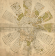
75.
Die Obere oder Nördliche Halbkugel der Erde auf den Horizont von Berlin stereographisch entworfen von T. E. Bode Astronom
der Königl. Pr. Acad. d. Wissensch. 1793, [and] Die Untere oder Südliche Halbkugel der Erde . . . [Berlin]: 1793.
|
1793. |
2 maps.
Sizes: 45.7 x 43.5 cm. and 43.5 x 43.3 cm.
|
(100: 1793: B631ger Large) |
|
76.
The world from the best authorities. [Boston]: Thomas & Andrews: [ca. 1796].
Engraver:
Amos Doolittle.
|
[ca. 1793]. |
Size of plate: 20.4 x 38.2 cm.
|
(100: [ca. 1793]: D722bos Small) |
|
Engraved for Morse's geography. [American Universal Geography, 1, front.]
Wheat: 19
|
|
|
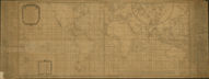
77.
A correct chart of the terraqueous globe, on which are described lines shewing the variation of the magnetic needle in the
most frequented seas; originally composed in the year 1700 by the celebrated Dr. Edmund Halley; renewed by William Mountaine
and James Dodson, F R S according to observations made about the year 1756. London: Laurie & Whittle: 1794 [12 May 1794].
Cartographer:
Edmund Halley, William Mountaine, and James Dodson.
|
12 May 1794. |
Size: 52.1 x 122 cm.
Size of paper: 55.3 x 147.9 cm.
|
(100: 1794: M865haL Large) |
|
On either side are: An account of the variation chart, and, Remarks on the variation lines &c.
|
|
|
78.
A general chart of the globe, shewing the course of the Gulph Stream, and various tracks to and from the East Indies, China,
Europe &c. [This is a chart on Mercator's projection with eight different lines lettered from "A" to "H" showing Truxtun's
courses between various points. 1794].
Cartographer:
Thomas Truxtun.
|
[1794]. |
Scale: 2.5 cm. = ca. 690 mi.
Size: 45.5 x 89.4 cm.
|
(527: T77) |
|
In: Thomas Truxtun, Remarks, instructions, and examples relating to the latitude and longitude . . ., frontispiece.
Wheat: 22
Provenance:
Presented by Thomas Truxtun, 17 February 1797.
|
|
|
78a.
General chart on Mercator's projection. [1798].
Engraver:
Rollinson.
|
[1798]. |
Scale: 2.5 cm. = ca. 35° latitude.
Size: 17.9 x 24.9 cm.
|
(910: P29) |
|
See: John Payne, A new and complete system of universal geography, vol. 1, opposite p. v.
Wheat: 39
|
|
|
78b.
The world from the best authorities [1798].
Engraver:
Rollinson.
|
[1798]. |
Size of page: 21 x 38 cm.
|
(910: P29) |
|
In: John Payne. A new and complete system of universal geography, vol. 1, frontispiece.
Wheat: 40
|
|
|
79.
Chart of the variation of the magnetic needle, for all the known seas comprehended within sixty degrees of latitude north
and south; with a new and accurate delineation of the magnetic meridians, accompanied with suitable remarks & illustrations. By Thomas Yeates. [London]: Black, Barbury & Allen: 1817 [22 August 1817].
Engraver:
J. Walker.
|
22 August 1817. |
Size: 53 x 122.8 cm.
Size of paper: 60.6 x 154.4 cm.
|
(100: 1817: Y39varc Large) |
|
Contains also: Remarks historical and explanatory; Deductions and experiments made by Capt. M. Flinders relating to the variation
of the magnetic needle; and Example of the aberration of the needle caused by a change in the ship's head.
Provenance:
Presented by John Garnett, prior to 1818.
|
|
|
80.
The world on Mercator's projection; revised and improved to 1818 by John Melish. Philadelphia: John Melish & Saml. Harrison: 1817 [16 October 1817].
Cartographer:
John Melish.
Engraver:
S. Harrison and G. Murray.
|
16 October 1817. |
Size: 91 x 123 cm.
Colored.
|
(100: 1817: M485wmp Large) |
|
Contains statistical table of the several countries shown on the map. Contains also tracks of various explorers: James Cook;
Vancouver; Furneaux; La Perouse; Clerke; Capt. Gore (Resolution); Commander James from Bombay; Capt. Phipps, Lord Musgrave; and of certain famous ships.
Provenance:
Presented by John Melish, 5 November 1819.
|
|
|
81.
A new and authentic map of the world embracing all the recent discoveries, and exhibiting particularly the nautical researches
of the most distinguished circumnavigators from the latest & best authorities with numerous corrections & additions, by H.
S. Tanner, 1831. Philadelphia: Tanner: 1831.
Cartographer:
H. S. Tanner.
Engraver:
E. B. Dawson.
|
1831. |
Size: 89.8 x 168.5 cm.
Colored.
|
(100: 1831: T158wnr Large) |
|
Contains also: comparative lengths of the principal canals in the world, projected on a scale of 34 miles to an inch; statistics
for North America, South America, West Indies; Summary of Africa, Asia, Oceania, and Europe statistics; heights of mountains;
British possessions in Africa, America, Asia, Oceania; possessions of European powers in Asia, Oceania, Africa, America; vertical
sections of North America, projected on uniform scales.
Provenance:
Presented by Henry Schenck Tanner, 15 April 1831.
|
|
|
82.
The world. Philadelphia: Engraved and published by W. Williams: 1842.
Engraver:
William Williams.
|
1842. |
Size: 51.6 x 63.9 cm.
Colored.
|
(100: 1842: W679eah Large) |
|
Insets: District of Columbia; Sandwich Islands; Map of Palestine and the Holy Land; and Map of the American Colony of Liberia.
Contains tracks of ships of Cook, Biscoe, Furneaux, Vancouver, La Perouse; Clarke; Gore, James Waddell, Columbus, etc.
|
|
|
83.
Colton's map of the world on Mercator's projection. New York: J. H. Colton & Co.: 1855.
|
1855. |
Size: 41 x 62.4 cm.
Colored.
|
(100: 1855: C672cwm Large) |
|
Contains isothermal lines of frigid or cold, temperate, tropical and equatorial zones; and, tracks of famous explorers and
ships: Cook, La Perouse, Vancouver, Furneaux, U.S.S. Vincennes, etc.
|
|
|
84.
Maps showing the location of the diplomatic and consular offices of the United States of America. 1 March 1888. Washington: Government Printing Office: 1888.
Cartographer:
A. C. Roberts and G. Noetzel.
Engraver:
N. Peters, Photo-Lithographer, Washington, D.C.
|
1888. |
8 maps.
Size: 44.7 x 54.7 cm.
|
(100: 1888: Un38dip Large) |
|
Contains index to the maps.
|
|
|
85.
Principal transportation routes of the world. U.S. Department of Commerce and Labor, Bureau of Statistics. N.p.: [ca. 1908].
|
[ca. 1908]. |
Size: 57.6 x 136.3 cm.
Size of paper: 81.3 x 145 cm.
Colored.
|
(100: [ca.1908]: P932trw Large) |
|
At bottom are distances from New York, New Orleans, San Francisco, and Port Townsend to the principal ports of the world and
the principal cities of the United States.
|
|
|
86.
[Map of the world]. Chicago: Geographical Publishing Co.: [ca. 1943].
|
[ca. 1943]. |
Size: 75.5 x 66 cm.
Colored.
|
(100: [ca.1943]: G293abc Roller) |
|
Contents include scenes from foreign lands and pictures of U.S. presidents to F. D. Roosevelt.
|
|
|
87.
Terrestrial magnetism. By Colonel Edward Sabine. Physical atlas. Plate 23. London: William Blackwood & Sons: n.d.
|
n.d. |
Size of paper: 53 x 66.4 cm.
Colored.
|
(100: n.d.: Salltem Large) |
|
Contains seven maps of the world.
Accompanied by a broadside which describes the plate.
Provenance:
Presented by Maj. Gen. Sabine.
|
|