|
|
|
|
|
|
|
|
|
|
|
|
|
|
|
|
|
North America
|
|
|
|
|
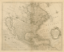
449.
Map of the British empire in America with the French and Spanish settlements adjacent thereto. London: 1733.
Cartographer:
Henry Popple and C. Lempriere.
Engraver:
B. Baron.
|
1733. |
Size: 232.5 x 229.6 cm.
Colored.
|
(635: 1733: P816bea Extra-oversize) |
|
Inset: New York harbor.
This huge map of the North American British Empire was given to the Society by Florens Rivinus on 21 March 1834. It was one
of the great maps which hung in Independence Hall in July 1776. Rivinus offered it for sale to the Society and a committee
was appointed on 5 May 1826 to report on its purchase. The committee thought the asking price was too high, so he presented
it eight years later.
During 1975-76 the map was deacidified and restored and was a major exhibition piece in the united 1976 Bicentennial Exhibition
of the Library Company of Philadelphia, Historical Society of Pennsylvania, and the American Philosophical Society.
For photograph see: 635: 1733: P816bea.p. Small.
|
|
|
450.
A map of North America with the European settlements & whatever else is remarkable in ye West Indies, from the latest and
best observations. [London: ca. 1744].
Engraver:
R. W. Seale.
|
ca. 1744. |
Size: 37.5 x 47 cm.
|
(600: [ca. 1744]: Se17nae Small) |
|
See: Paul Rapin de Thoyas, The history of England. Continued by N. Tindal. London: 1744: vol. 3.
|
|
|
451.
North America from the French of Mr. D'Anville improved with the back settlements of Virginia and course of Ohio. Illustrated with geographical and historical remarks. [London]: T. Jefferys: 1755 [May 1755].
Cartographer:
D'Anville and T. Jefferys.
|
May 1755. |
Scale: 69½ English mil. = 1 degree.
Size: 46 x 51.1 cm.
Colored.
|
(601: 1755: An91nav Large) |
|
Ingersoll wrote 14 April 1837 that he had "four antient maps . . . some of which I believe are rare and valuable." He added
that he was too busy, even to attend meetings, but "absence does not diminish at all the great respect I entertain" for the
Society.
[This is the only map I can determine that came from Ingersoll which is "rare and valuable"]: MDS.
Provenance:
Presented by C. J. Ingersoll, 7 April 1843.
|
|
|
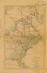
452.
A map of the British and French dominions in North America with the roads, distances, limits, and extent of the settlements. Jno. Mitchell. [London: 1757] 2nd ed.
Cartographer:
John Mitchell.
Engraver:
Thomas Kitchin, Clerkenwell Green.
|
[1757]. |
Scale: 69½ English mi. = 1 degree.
Size: 135 x 194.6 cm.
|
(602: [1757]: M695bfd Large) |
|
Inset: A new map of Hudson's Bay and Labrador.
|
|
|
453.
A map of the British Empire in North America; by Samuel Dunn. London: Robert Sayer: 1774 [10 January 1774].
Cartographer:
Samuel Dunn.
|
10 January 1774. |
Scale: 69½ English mi. = 1 degree.
Size: 47 x 30.4 cm.
Colored.
|
(601: 1774: D912bna Large) |
|
Former Secretary of the Treasury, Albert Gallatin, wrote 7 November 1828 requesting the loan of particular maps for use in
settling the Northeast Boundary Dispute with Great Britain. Secretary John Vaughan acquired some for him from Samuel Hazard
and the "City Library," as well as some from the Society's library. Gallatin wrote that "in every case where we have but one
engraved copy of a Map, we are bound to deliver a manuscript copy to the British Minister here on 1st of January next." He
stated that the map he wanted more than any other, is in truth the same map, but bearing on the face of it the date of 1776 to 1782 (or 1777 I believe) and not having the word "United States" on it or in it. The title is in substance as follows vizt:
A new and correct map of North America with the West Indian Islands, divided according to the last treaty of peace concluded
at Paris 10th February 1763, corrected from the original materials of Govr. Pownal M.P. Sayer & Bennet 1777. But it may vary a little in the said title & been any date from 1775 to 1782 [Archives].
Vaughan shipped the maps 16 November, and Gallatin retained two which belonged to the Society [22 November 1828, Archives].
As "U.S. Agent for the N.E. boundary," he signed for these two on 26 December: "Sayer & Bennett's U.States-Feby 1783" and
"Dunn's British Empire 1774." They were to be "laid before the Arbiter" and they would be "returned, replaced, or, in case
of unavoidable accident, compensated for by the United States" [Archives, Receipt]. He returned the unused maps 2 January
1829 and sent his "thanks and those of the Government for your zealous and useful services on this important occasion" [Archives].
These maps were not returned by 1843 so the members instructed Secretary George Ord on 15 December to recover them. Ord wrote
immediately to Gallatin who replied 19 December, explaining what happened to them:
Sayer & Bennet's United States, delivered to the British Minister at Washington, as part of the evidence to be laid before the Arbiter and which, in conformity
with the Convention, the U. States were bound to communicate to the British Government on the 31st Dec[emb]er 1828. - cannot
be recovered. Dunn's British Empire, laid before the Arbiter. All the maps laid before the King of Holland were bound together at Washington. That Atlas was,
I understand, brought back from Holland by Mr. Treble and must be in the Department of State [Archives].
On 18 May 1852, Acting Secretary of State William Hunter returned the Sayer and Bennett map. It had been found "this morning"
and Hunter hastened "to restore it to your Society" [Archives].
The Dunn map was returned 15 December 1852 by Secretary of State Edward Everett. He wrote member C. B. Trego that the map
was returned by direction of the President "with the thanks of this Department for its use" [Archives].
For the Sayer and Bennett map, see: No. 550.
|
|
|
454.
North America, as divided amongst the European Powers. By Samuel Dunn. London: Robert Sayer: 1774 [10 January 1774].
Cartographer:
Samuel Dunn.
|
10 January 1774. |
Size: 30.5 x 44.5 cm.
Colored.
|
(600: 1774: D912naep Small) |
|
The American Military Pocket Atlas (Pam. 912.7:Am3). Maps removed from binding 5 November 1962.
|
|
|
455.
Carte nouvelle de l'Amérique angloise contenant tout ce que les anglois possédent sur le continent de l'Amérique Septentrionale
savior le Canada, la nouvelle Ecosse ou Acadie, les treize provinces unies qui sont les quatre colonies de la Nouvelle Angleterre
1. New Hampshire, 2. Massachusetsbaye, 3. Rhode-Island & 4. Connecticut, 5. la Nouvelle York, 6. Nouvelle Jersey, 7. Pensilvanie, 8. les comtés de Newcastle, Kent et Sussex sur la Delaware, 9. Mariland, 10. Virginie, 11.
la Caroline Septentrionale, 12. la Caroline Méridionale et 13. Géorgie avec la Floride. Augsburg: [1776?].
Engraver:
Matthieu Albrecht Lotter.
|
[1776?]. |
Scale: 1:20 leagues.
Size: 60 x 49.1cm.
Colored.
|
(602: [l776?]: L915asc Large) |
|
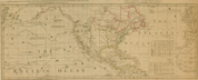
456.
North America and the West Indies, with the opposite coasts of Europe and Africa. Chart, containing the coasts of California, New Albion, and Russian discoveries to the north; with the peninsula of Kamtschatka,
in Asia, opposite thereto; and islands, dispersed over the Pacific Ocean, to the north of the line. London: Robert Sayer:
1787 [10 November 1787].
|
10 November 1787. |
Size of plate: 45.3 x 113 cm.
Colored.
|
(130: 1787: Sa97naw Small) |
|
Shows routes of early navigators.
|
|
|
457.
A general map of North America from the best authorities. [1790].
Engraver:
Scot.
|
[1790]. |
Size: 17.8 x 22.6 cm.
|
(032: En2) |
|
In: Thomas Dobson, publisher, Encyclopaedia, vol. 1, opposite p. 538.
Wheat: 51
Provenance:
Presented by Thomas Dobson, 1798.
|
|
|
458.
A new map of North America showing all the new discoveries.
Engraver:
Hill.
|
1797. |
Size: 19.3 x 12.5 cm.
|
(917.3: M83am) |
|
In: Jedidiah Morse, The American gazetteer, frontispiece. Incomplete.
Wheat: 60
|
|
|
459.
A map of North America from the latest authorities. 1799.
|
1799. |
Size: 18.3 x 21.7 cm.
|
(910: P29) |
|
In: John Payne, A new and complete system of universal geography, vol. 4, opposite p. 11.
Wheat: 65
|
|
|
460.
Charte von Nord America nach astronomischen Bestimmungen und den neuesten Charten von Dalrymple, Arrowshmit, Edwards, u.a.m.
neu entworfen von F. L. Güssefeld. Nürnberg: Homann: 1806.
Cartographer:
F. L. Güssefeld.
Engraver:
I. Rausch.
|
1806. |
Scale: 69 12/100 English mi. = 1 Grad.
Size: 45.4 x 54.1.
Colored.
|
(600: 1806: R197cna Small) |
|
461.
Map of North America exhibiting the boundaries arranged agreeably to the late British and Spanish treaties. Philadelphia: Tanner, Vallance, Kearny & Co.: 1819.
Engraver:
Tanner.
|
1819. |
Size: 45.3 x 51 cm.
Colored.
|
(130: 1819: T158bst Small) |
|
462.
North America. A working map for illustrating, by coloration, the geographical distribution of life. Prepared for the Boston Society of
Natural History by William C. Cleveland. Authorities Johnston's Royal Atlas, & recent discoveries . . . Isothermal data by
Prof. Arnold Guyot. [Boston]: American Photo-Lithographic Co.—Osborne's Process: 1868.
Cartographer:
Samuel H. Scudder and William C. Cleveland.
Engraver:
American Photo-Lithographic Company.
|
1868. |
Scale: 4.1 cm. = 200 English mi.
Size: 56.6 x 44 cm.
|
(601: 1868: C592gna Large) |
|
463.
Map of North America, reduced from map on scale of 1:5,000,000. Compiled by the U.S. Geological Survey, George Otis Smith, director. [Washington]: U.S. Geological Survey: 1912.
Cartographer:
U.S. Geological Survey.
Engraver:
U.S. Geological Survey.
|
1912. |
Scale: 1:10,000,000.
Size: 95.4 x 72.9 cm.
Colored.
|
(120: 1912: Un38int Large) |
|
Inset: Windward Islands and Aleutian Islands.
|
|
|
464.
Map of North American Indian languages. Compiled and drawn by C. F. and E. W. Voegelin. New York: J.J. Augustin, Inc.: 1941.
Cartographer:
C. F. and E. W. Voegelin.
|
1941. |
Size: 84 x 90.5 cm.
Colored.
|
(130: 1941: V857nai Large) |
|
See: American Ethnological Society, Publications, No. 20.
|
|
|
465.
Glacial map of North America published by the Geological Society of America. First edition. N.p.: 1945.
Cartographer:
Richard F. Flint, Wm. C. Alden, E. T. Apfel, H. S. Bostock, S. R. Capps, J. W. Goldthwait, L. M. Gould, George F. Kay, M.
M. Leighton, Frank Leverett, Paul MacClintock, D. A. Nichols, G. W. H. Norman, F. T. Thwaites, George W. White, and G. A.
Young.
|
1945. |
2 pieces.
Scale: 1:4,555,000.
Size: 133.4 x 200.8 cm.
Colored.
|
(130: 1945: F644gLm Large) |
|
Inset: Glacial map of the north polar hemisphere; Index map; Principal loess distribution in central United States.
|
|
|
466.
Geologic map of North America . . . Under grants from the Geological Society of America, the American Philosophical Society,
the American Association of Petroleum Geologists. Bailey Willis, grantee. Washington: Geological Society of America: 1946.
Cartographer:
Bailey Willis.
|
1946. |
2 sections.
Scale: 1:5,000,000.
Size: 96 x 134 cm.
|
(130: 1946: St67nha Roller) |
|
Photograph.
|
|
|
467.
[New chart of the English empire in North America]. Engraven and printed by Fra. Dewing, Boston, New England, 1717. Reproduced in collotype by the Meriden Gravure Company: 1961.
Cartographer:
Cyprian Southack.
Engraver:
Francis Dewing.
|
1961. |
4 pieces.
Scale: 4 cm. = 100 mi.
Size: Each piece: 35.5 x 41 cm.
|
(635: 1961: So87cyp Small) |
|
Facsimile.
Contains four columns of place names.
Original in John Carter Brown Library, Providence, Rhode Island, 1942.
Notes of Southack map accompany the facsimile.
Wheat: 44
|
|
|
468.
Map of North American Indian languages. Compiled and drawn by C. F. and F. W. Voegelin. Copyright 1966 by the American Ethnological Society. Prepared and printed
by Rand McNally & Company, U.S.A. Revised edition. N.p.: [1966].
Cartographer:
C. F. and F. M. Voegelin.
|
[1966]. |
Scale: 1 inch = 100 mi.
Size: 149.4 x 120 cm.
|
(130: [1966]: V857nai Extra-oversize) |
|
469.
North America at the time of the Revolution. A collection of eighteenth century maps with introductory notes by Louis De Vorsey, Jr. Part II. Ashford, Kent: Harry Margery,
Lympne Castle, Kent: 1974. 22 sheets: 5 maps (title page, 2 p. of introduction, and 19 map sheets).
|
1974. |
Size: various.
|
(601: 1974: N81d Large) |
|
Facsimile reproductions.
Contents: John Mitchell. A map of the British colonies in North America. London: 1755 (8 sheets); Joshua Fry and Peter Jefferson.
A map of the most inhabited part of Virginia. London: 1755 (4 sheets); C.J. Sauthier. A topographical map of Hudson River.
London: 1776 (1 sheet); Samuel Holland. The provinces of New York and New Jersey with part of Pensilvania. London: 1776 (2
sheets); and Thomas Jefferys. A map of the most inhabited part of New England. London: 1774 (4 sheets).
|
|
|
470.
Europe and North America on Mercator's projection. N.p.: n.d. Map in 6 pieces.
|
n.d. |
Scale: 5 cm. = 110 statute mi.
Size: 90 x 58 cm. each.
|
(610: n.d.: Eu72noa Large) |
|
Inset: Europe and North America.
|
|