|
|
|
|
|
|
|
|
|
|
|
|
|
|
|
|
|
Middle Atlantic States
|
|
|
|
|
750.
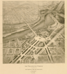
[Coast of North America from Cape Hatteras to Boston harbor. 1747].
Cartographer:
Lewis Evans (?).
Engraver:
James Turner.
|
[1747]. |
Size: 39.6 x 30.4 cm.
|
(347.8: N46b) |
|
In: Board of general proprietors of the eastern division of New Jersey. A bill in the chancery of New-Jersey, following p. 124.
Wheat: 294
|
|
|
751.
A map of Pensilvania, New-Jersey, New-York, and the three Delaware counties: by Lewis Evans. MDCCXLIX. Published by Lewis Evans March 25, 1749 according to act of Parliament. [Philadelphia]: 1749.
Cartographer:
Lewis Evans.
Engraver:
L. Hebert.
|
1749. |
Scale: 69 English mi. = 1 degree.
Size: 64.4 x 49.1 cm.
Colored.
|
(640.2: 1749: Ev12tdc Large) |
|
Norris's copy has now disappeared. It was being used as late as 5 October 1832, for James Mease commented that there was a
marginal note by Evans that "all great storms begin at the leeward." Somehow, this note strengthened Mease's theory that the
present earth "was made at the creation from the ruins of another" (Minutes).
Wheat: 672
Contains comments about the origins of the northeast storms (suggested by B. Franklin?), lightning and electricity, navigation
of the Delaware River, and other bays, etc.
Endorsement on back, in Benjamin Franklin's hand: "To Dr. John Mitchell from Mr. B. Franklin." The map was at one time in
the collection of the Marquess of Bute, a friend of Mitchell's.
Provenance:
Joseph Parker Norris gave a copy of this map to the American Philosophical Society on 16 June 1815.
|
|
|
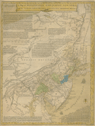
752.
A general map of the middle British colonies, in America, viz Virginia, Màriland, Dèlaware, Pensilvania, New-Jersey, New-York,
Connecticut, and Rhode Island: of Aquanishuonîgy, the country of the Confederate Indians; comprehending Aquanishuonîgy proper,
their place of residence, Ohio and Tiiuxsoxrúntie their deer-hunting countries, Couxsaxráge and Skaniadarade, their beaver-hunting
countries; of the lakes Erie, Ontario and Champlain, and part of New France; wherein is also shewn the antient and present
seats of the Indian nations. By Lewis Evans. 1755. Published according to act of Parliament, by Lewis Evans, June 23, 1755, and sold by R. Dodsley, in
Pall-Mall, London, & by the author in Philadelphia. [Philadelphia: Franklin]: 1755.
Cartographer:
Lewis Evans.
Engraver:
James Turner.
|
1755. |
Scale: 5 cm. = 60 mi.
Size: 49.5 x 66.5 cm.
Colored.
|
(635: 1755: Evl2bca Large) |
|
Inset: A sketch of the remaining part of Ohio R. &c.
Wheat: 298
|
|
|
753.
A general map of the middle British colonies in America (viz) Virginia, Delaware, Pensilvania, New Jersey, New York, Connecticut
& Rhode Island. Of Aquanishuonigy, the country of the Confederate Indians, comprehending Aquanishuonigy proper, their place of residence,
Ohio & Tiiusoxruntie, their deer hunting countries, Couxsaxrage & Skaniadarade, their beaver hunting countries. Of the Lakes
Erie, Ontario and Champlain and part of New France. 1766.
|
1766. |
Size: 50 x 67.5 cm.
Colored.
|
(635: 1766: Evvar Extra-oversize) |
|
Inset: A sketch of the remaining part of the Ohio River, etc.
This map is a variant of the Lewis Evans map of 1755. It is a proof by Meriden Gravure company, and was never published.
Provenance:
Presented by C. William Miller, May 1967.
|
|
|
754.
A map of that part of America where a degree of latitude was measured for the Royal Society by Charles Mason and Jere[my]
Dixon. [London: 1769?].
|
[1769?]. |
Size: 16.6 x 9.6 cm.
|
(635: [1769?]: M385aL Small) |
|
Variation of map reproduced in Royal Society of London, Philosophical Transactions, 1769, vol. 58, p. 325.
For letter related to above map see: "Claims of Maryland, Pennsilvania . . ."
|
|
|
755.
[A map of part of Pennsylvania, Delaware & Maryland intended to shew, at one view, the several places proposed for opening
a communication between the waters of the Delaware & Chesopeak Bays. 1771].
Engraver:
J. Smither.
|
[1771]. |
Scale: 2.5 cm. = 7¾ mi.
Size of plate: 31.2 x 44.6 cm.
|
(506.73: Am4t, vol. 1) |
|
In: American Philosophical Society. Transactions, vol. 1, following p. 292.
Wheat: 300
|
|
|
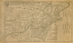
756.
A general map of the Middle British colonies, in America. Containing Virginia, Maryland, the Delaware Counties, Pennsylvania, and New Jersey. With the addition of New York, and of
the greatest part of New England, as also of the bordering parts of the Province of Quebec. Improved from several surveys
made after the late war, and corrected from Governor Pownall's late map 1776. [Title on top of sheet]: The seat of war in
the middle British colonies, containing Virginia, Maryland, the Delaware Counties, &c. London: R. Sayer and J. Bennett: 1776
[15 October 1776].
Cartographer:
T. Pownall.
|
[15 October 1776]. |
Scale: 69½ British statute mi. = 1 degree.
Size: 48.8 x 66.5 cm.
Colored.
|
(635: [1776]: P876mbc Large) |
|
Inset: A sketch of the upper parts of Canada.
Originally in American military atlas; removed from binding 5 November 1962.
|
|
|
757.
A map of the middle British colonies in North America. First published by Mr. Lewis Evans, of Philadelphia, in 1755; and since corrected and improved, as also extended, with the
addition of New England and bordering parts of Canada; from actual surveys now lying at the Board of Trade. By T. Pownall.
London: J. Almon: 1776 [25 March 1776].
Cartographer:
Lewis Evans and T. Pownall.
Engraver:
James Turner.
|
[25 March 1776]. |
Scale: 7 cm. = 90 mi.
Size: 49.3 x 82.4 cm.
Colored.
|
(635: 1776: P876bc Large) |
|
Inset: A sketch of the remaining part of Ohio R. &c.
|
|
|
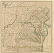
758.
A new map of the western parts of Virginia, Pennsylvania, Maryland and North Carolina; comprehending the River Ohio, and all
of the rivers, which fall into it; part of the River Mississippi, the whole of the Illinois River, Lake Erie; part of the
Lakes Huron, Michigan &c. And all the country bordering on these lakes and rivers. By Thos. Hutchins. London: Hutchins: 1778 [1 November 1778].
Cartographer:
Thomas Hutchins.
Engraver:
T. Cheevers.
|
[ 1 November 1778]. |
Scale: 1 in. = 20 mi.
Size: 90 x 110.3 cm.
Colored.
|
(635: 1778: H973vpm Large) |
|
759.
A map of the country between Albermarle Sound and Lake Erie, comprehending the whole of Virginia, Maryland, Delaware and Pennsylvania,
with parts of several other of the United States of America. Engraved for the Notes on Virginia. The country on the eastern side of the Allegany Mountains, is taken from Fry and Jefferson's
map of Virginia, and Scull's map of Pennsylvania, which were constructed chiefly on actual survey; that on the western side
of the Alleganey, is taken from Hutchins, who went over the principal water courses, with a compass and log-line, correcting
his work by observations of latitude; additions have been made, where they could be made on sure ground. [Paris: 1786].
Cartographer:
Fry, Jefferson, Scull, and Hutchins.
Engraver:
S. J. Neele.
|
[1786]. |
Size: 59.9 x 59.6 cm.
Colored.
|
(917.55: J35) |
|
The Society asked Thomas Jefferson in 1805 for a copy of his Notes on Virginia. Jefferson wrote 2 May 1805 and presented "a single copy remaining of the original edition printed at Paris, the only one
almost perfectly correct, & was never sold, a few copies only having been printed and given to my friends" (Archives).
In: Thomas Jefferson, Notes on Virginia.
|
|
|
760.
[A map of part of Pennsylvania, Delaware and Maryland intended to shew, at one view, the several places proposed for opening
a communication between the waters of the Delaware and Chesopeak Bays]. [1771].
Cartographer:
W. T. [Thomas] Fisher.
Engraver:
J. Smither.
|
[1771]. |
Scale: 2.5 cm. = 7¾ mi.
Size of plate: 31.2 x 44.6 cm.
|
(506.73: Am4t, vol. 1) |
|
The idea of a canal linking the Delaware River and Chesapeake Bay was of long standing when the Society formed a committee
to arrange for a survey of the general area. Merchants of Philadelphia financed the early surveys and on 16 June 1769, Thomas
Gilpin, one of the "Merchants' appointees," exhibited his plan of a canal with the elevation between Chester River and Duck
Creek, and he included an estimate "for flat bottomed boats, carrying 1,000 bushels, £8050; for shallops &c., £28,298." The
Society also received an elevation of the land between the Bohemia and Apoquinimy Rivers with the locks necessary to carry
vessels from the tidewater of the Delaware to that of the Chesapeake. "The Distance from Tide to Tide is 5 Miles & 107 perches"
(APS Minutes).
W. T. Fisher (Thomas Fisher) delivered a map of the proposed canal 2 March 1770 which was
intended to shew, at one View, the several places proposed for opening a
communication between the waters of the Delaware and Chesapeake Bays . . . to be
kept among the Society's papers for future use. In this Map is also delivered the
different Roads proposed to be opened for Land Carriage
from the Susquehanna River. On 2 November 1770, the "Abstract of Canal papers read & ordered to be printed. Fisher's map ordered
to be engraved" (APS Minutes).
The desire for this canal continued and it is interesting to note that as late as 16 December 1803 two of the maps belonging
to the Society, the surveys by Anderson and Gilpin, were acknowledged as being in the possession of Benjamin Henry Latrobe.
Latrobe had surveyed a route in 1799 and was named Engineer of the Chesapeake and Delaware Canal Company in 1804 when the
first canal was dug.
In: American Philosophical Society. Transactions, vol. 1.
Wheat: 300
|
|
|
760a.
[A map of part of Pennsylvania, Delaware and Maryland intended to shew, at one view, the several places proposed for opening
a communication between the waters of the Delaware & Chesopeak Bays. 1789].
Engraver:
J. Smither.
|
[1789]. |
Scale: 2.5 cm. = 7¾ mi.
Size of plate: 31.2 x 44.6 cm.
|
(506.73: Am4t) |
|
In: American Philosophical Society. Transactions, vol. 1, 2nd ed. corrected (1789), opp. p. 367.
Wheat: 305
|
|
|
761.
A new map of the states of Pennsylvania, New Jersey, New York, Connecticut, Rhode Island, Massachusetts and New Hampshire,
including Nova Scotia and Canada, from the latest authorities. New York: 1789.
Engraver:
C. Tiebout.
|
1789. |
Size: 27 x 40.3 cm.
|
(Paine 68: G65h) |
|
In: William Gordon, History of the rise of the United States. New York: Hodge, Allen and Campbell: 1789. Frontispiece, vol. 2.
Wheat: 150
Provenance:
Presented by John Vaughan, May 1818; by the Estate of Richard Gimbel, 1974.
|
|
|
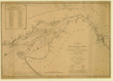
762.
A chart of Delaware Bay and River, containing a full and exact description of the shores, creeks, harbours, soundings, shoals,
sands and bearings of the most considerable land marks, &c. &c. Faithfully copied from that published at Philadelphia. By Joshua Fisher, together with the tide table from the capes to Philadelphia
. . . London: Laurie and Whittle: 1794 [12 May 1794].
Cartographer:
Joshua Fisher.
|
[12 May 1794]. |
Scale: 69½ English mi. = 1 degree.
Size: 46.8 x 68.6 cm.
|
(640.2: 1794: F533db Large) |
|
Original in North American pilot. . . London: Laurie and Whittle: 1800. No. 10.
|
|
|
763.
A map of Pennsylvania, Delaware, New Jersey & Maryland, with the parts adjacent [1798].
Engraver:
Thackara.
|
[1798]. |
Scale: 2.5 cm. = 28 mi.
Size: 31 x 38.5 cm.
|
(974.8: P94) |
|
In: Robert Proud, The history of Pennsylvania, vol. 2, frontispiece.
Wheat: 312
Provenance:
Presented by Robert Proud, 18 June 1802.
|
|
|
764.
A map of the middle states, shewing the situation of the Genesee lands & their connection with the Atlantic coast. 1798.
|
1798. |
Scale: [2.5 cm. = ca. 35 mi].
Size: 26 x 24.7 cm.
|
(974.7: W67) |
|
In: Charles Williamson, Description of the Genessee country, following p. 37.
Wheat: 313
|
|
|
765.
A map of the middle states of North America, shewing the position of the Geneseo country comprehending the counties of Ontario
& Steuben as laid off in townships of six miles square each. 1799.
Engraver:
Maverick.
|
1799. |
Scale: 2.5 cm. = ca. 33 mi.
Size: 37.3 x 39.8 cm.
|
(974.7: W67d) |
|
In: Charles Williamson, Description of the settlement of the Genesee country, frontispiece.
Wheat: 316
|
|
|
766.
A map exhibiting the different stage routs, between the cities of New-York, Baltimore, and parts adjacent. To which is added, as an historical companion, the operations of the British army, from their landing at Elk River in 1777,
to their embarkation at Nevisink in 1778. By John Hills. Philadelphia: E. Savage: 1800.
Cartographer:
John Hills.
|
1800. |
Scale: 2.5 cm. = 3 mi.
Size: 28 x 152.1 cm.
Colored.
|
(635: 1800: H553nyb Large) |
|
767.
[Map of Pennsylvania, Delaware and Maryland; showing proposed new roads and canals]. Plate VII, fig. 1. [Philadelphia: ca. 1800].
Engraver:
J. Smither.
|
[ca. 1800]. |
Scale: 1 cm. = 3 mi.
Size of paper: 32.7 x 41 cm.
|
(635: [ca. 1800]: Sm67pdm Small) |
|
See: American Philosophical Society. Transactions, n.s., vol. 1, pl. 7: "An abstract of sundry papers and proposals for improving the inland navigation of Pennsylvania and
Maryland, by opening a communication between the tide-waters of Delaware or Susquehanna, or Chesopeake Bay . . ." See Maps
760 and 760a, above.
|
|
|
768.
A new map of the seat of war. N.p.: [ca. 1815].
Cartographer:
S. Lewis.
Engraver:
J. Bower.
|
[ca. 1815]. |
Scale: 1 in. = 42 mi.
Size: 34.2 x 46 cm.
|
(640.2: [ca. 1815]: L585msw Small) |
|
Inset: Niagara River.
|
|
|
769.
Map of reconnaissance between Baltimore and Philadelphia exhibiting the several routes of the mail-road contemplated by the
resolution of Congress approved on the 4th of May 1826. U.S. War Department. [Washington: 1826].
Cartographer:
S. Bernard and William Tell Poussin.
|
1826. |
Scale: 1 in. = 3 mi.
Size: 22.3 x 79.6 cm.
|
(650: 1826: Un38rbp Large) |
|
770.
Map of the country between Washington & Pittsburgh referring to the contemplated Chesapeake & Ohio canal and its general route
and profile. October 1826. Reduced from the general map, annexed to the report upon the contemplated canal, & drawn by Lieut. Farley . . . U.S. War
Department. Georgetown, D.C.: 1826.
Cartographer:
John Farley.
Engraver:
William Harrison and D. R. Harrison.
|
1826. |
Scale: 1 in. = 8 mi.
Size: 45.4 x 64.5 cm.
Colored.
|
(635: 1826: Un38wpo Large) |
|
771.
A map showing the effect of a connection between the Delaware Division and the Delaware and Raritan canal. Philadelphia: Watson's Lith.: [1835].
Engraver:
Watson.
|
[ca. 1835]. |
Size of paper: 49.2 x 65.8 cm.
|
(640.2: [ca. 1835]: W339drc Small) |
|
772.
Geological map of the middle and western states. By James Hall. New York: Endicott Lithographer: [ca. 1848].
Cartographer:
James Hall.
Engraver:
Endicott.
|
[ca. 1848]. |
Scale: 1 in. = 30 mi.
Size: 58.4 x 82.4 cm.
|
(635: [ca. 1848]: H143mws Large) |
|
773.
General chart of the coast from Gay Head to Cape Henlopen. From a trigonometrical survey under the direction of F. R. Hassler and A. D. Bache. U.S. Coast and Geodetic Survey. [Washington]:
1852.
Cartographer:
F. R. Hassler and A. D. Bache.
|
1852. |
Scale: 1:400,000.
Size: 78.3 x 95.3 cm.
|
(635: 1852: Un38ghh Large) |
|
Contains six views and five sections of the slope of the ocean bottom.
Provenance:
Presented "pursuant of an Act of Congress, and by the direction of the Treasury Department" through A. D. Bache,
10 October 1854.
|
|
|
774.
Military maps illustrating the operations of the armies of the Potomac & James May 4th, 1864 to April 9th, 1865 including
battlefields of the Wilderness, Spottsylvania, Northanna, Totopotomoy, Cold Harbor, the siege of Petersburg and Richmond. Battlefields of Five Forks, Jetersville & Sailor's Creek, Highbridge, Farmville & Appomatox Court-House. U.S. War Department.
New York: J. Bien: 1867. 15 maps and title page.
Engraver:
J. Bien.
|
1867. |
Scale: 3 in. = 1 mi.; 1½ in. = 1 mi.
Size of paper: 61.1 x 45.4 cm.
Colored.
|
(635: 1867: Un38apj Large) |
|
List of maps: 1. North Anna. 2. Cold Harbor. 3. Chancellorsville. 4. Harper's Ferry. 5. Fredericksburg. 6. High Bridge & Farmville.
7. Bermuda Hundred. 8. Jetersville & Sailors Creek. 9. Petersburg & Five Forks. 10. Totopotomoy. 11. Spottsylvania Court House.
12. The Wilderness. 13. Appomattox Court House. 14. Richmond. 15. Antietam.
Provenance:
Presented by the U.S. War Department, 4 November 1870.
|
|
|
775.
Map of the region between Gettysburg, Pa., and Appomattox Court House, Va., exhibiting the connection between the campaign
and battle-field maps . . . under the direction of Brig. & Bvt. Maj. Gen. A. A. Humphreys . . . by N. Michler. U.S. War Department. [Washington]: 1869.
Cartographer:
N. Michler, John E. Weyss, C. Thompson, J. de la Camp, and A. A. Humphreys.
|
1869. |
Scale: 1:300,000.
Size: 111.3 x 69.3 cm.
Colored.
|
(635: 1869: Un38cbf Large) |
|
776.
Map of the Buffalo, New York and Philadelphia R. R. and its principal connections. New York: [ca. 1880].
Cartographer:
F. S. Cook.
|
[ca. 1880]. |
Scale: 1 in. = 20 mi.
Size: 53.9 x 84.5 cm.
Colored.
|
(640.2: [ca. 1880]: C772byp Large) |
|
777.
Post route map of the states of Pennsylvania, New Jersey, Delaware and Maryland and of the District of Columbia with adjacent
parts of New York, Ohio, Virginia and West Virginia. Designed and constructed under the orders of the U.S. Post Office Department Postmaster General . . . by W. L. Nicholson.
Washington: 1880. 1st ed. 1869.
Cartographer:
C. H. Poole and W. L. Nicholson.
Engraver:
D. McClellan.
|
1880. |
Scale: 1 in. = 6 mi.
Size: 153 x 153 cm.
Colored.
|
(635: 1880: Un38pod Large) |
|
778.
Map of the Buffalo, Pittsburgh & Western R. R. & connections. N.p.: 1881.
|
1881. |
Size: 57.1 x 60.4 cm.
Colored.
|
(640.2: 1881: B861wrr Large) |
|
779.
Map of the railroads of Pennsylvania and New Jersey and parts of adjoining states. 1882. Prepared from official data by J. A. Anderson. Philadelphia: Smith and Stroup: 1882.
Cartographer:
J. A. Anderson.
|
1882. |
Scale: 1 in. = 8 mi.
Size: 98.5 x 121.5 cm.
Colored.
|
(640.2: 1882: An21pnj Large) |
|
Inset: Map showing the eastern shore of Maryland & Virginia.
|
|
|
780.
Post route map of the state of New York, and parts of Vermont, Massachusetts, Connecticut, New Jersey and Pennsylvania. Also the adjacent portions of the Dominion of Canada, showing post offices, with the intermediate distances between them
and mail routes in operation on 1st June 1884. [Washington]: 1884. 1st ed. issued 1868.
|
1884. |
Scale: 1:380,160.
Size: 140.2 x 156.7 cm.
Colored.
|
(647: 1884: Un38prm Large) |
|
Insets: Postal service of Long Island, with the principal mail connections of the city of New York; map of the Lake St. Frances
to Montreal area, Canada.
|
|
|
781.
New York-New Jersey. New York sheet. U.S. Geological Survey. J. W. Powell, director. Surveyed in 1888-1889. [Washington]: 1888. Edition of 1892.
Cartographer:
Henry Gannett and J. W. Powell.
|
1892. |
Scale: 1:62,500.
Size: 91.8 x 71.1 cm.
Colored.
|
(640.2: 1892: Un38nyj Large) |
|
782.
Bridgeport Quadrangle. New Jersey-Pennsylvania. Marcus Hook quadrangle. Pennsylvania-Delaware-New Jersey. U.S. Department of the Interior. Geological
Survey. [Washington]: 1953. Edition of 1953.
|
1953. |
2 sheets.
Scale: 1:24,000.
Size: 57.7 x 44.6 cm.
Colored.
|
(640.2: 1953: Un38pdn Large) |
|
New York
|
|
|
|
|
783.
A map of the countrey of the Five Nations belonging to the province of New York and of the lakes near which the nations of
the Far Indians live with part of Canada taken from the map of the Louisiane done by Mr. Delisle in 1718. [1724].
Cartographer:
de l'lsle.
|
[1724]. |
Scale: 2.5 cm. = 80 mi.
Size: 21.8 x 35.2 cm.
|
(970.1: C67p) |
|
In: Cadwallader Colden, Papers relating to an act of New York for encouragement of the Indian trade, frontispiece.
Wheat: 317
|
|
|
784.
A survey of Lake Champlain, including Lake George, Crown Point and St. John. Surveyed by order of . . . Jeffrey Amherst. By William Brassier. 1762. London: Robt. Sayer & Jn. Bennett: 1776 [5 August
1776].
Cartographer:
William Brassier and Capt. Jackson.
|
1762. |
Scale: 2 cm. = 5 mi.
Size: 66.2 x 47.9 cm.
Colored.
|
(647: 1762: Bcja Large) |
|
Inset: A particular plan of Lake George. Surveyed in 1756 by Capt. Jackson.
This was removed from: The American military pocket atlas. R. Sayer and J. Bennett: [1776].
|
|
|
785.
A map of the present seat of war on the borders of Canada. [Philadelphia: Aitken: 1775].
|
[1775]. |
Scale: 1 in. = 10 mi.
Size: 38.9 x 15.4 cm.
|
(647: [1775]: Ai11wbc Small) |
|
At top of map is: "for the Penna Magazine p. 463" [see: Pennsylvania Magazine. 1775, vol. 1].
Wheat: 89
|
|
|
786.
The southern part of the province of New York: with part of the adjoining colonies. By Tho[ma]s Kitchin, sen[io]r hydrographer to His Majesty. [London]: R. Baldwin: 1778.
Cartographer:
T. Kitchin.
|
1778. |
Size: 24.7 x 18.4 cm.
|
(647: 1778: K644pny Small) |
|
At top of map is: "For the London Magazine 1778" [vol. 47, March 1778, p. 99].
|
|
|
787.
From Albany (26) to Newborough. [1789, 1961 reprint].
|
[1789]. |
Size: 17 x 11.5 cm.
|
(526.8: C68s) |
|
In: Christopher Colles, A survey of the roads.
Wheat: 349
|
|
|
788.
From Albany (27) to Newborough. [1789, 1961 reprint].
|
[1789]. |
Size: 17 x 11.3 cm.
|
(526.8: C68s) |
|
In: Christopher Colles, A survey of the roads.
Wheat: 350
|
|
|
789.
From Albany (28) to Newborough. [1789, 1961 reprint].
|
[1789]. |
Size: 17 x 11.4 cm.
|
(526.8: C68s) |
|
In: Christopher Colles, A survey of the roads.
Wheat: 351
|
|
|
790.
From Albany (29) to Newborough. [1789, 1961 reprint].
|
[1789]. |
Size: 17 x 11.4 cm.
|
(526.8: C68s) |
|
In: Christopher Colles, A survey of the roads.
Wheat: 352
|
|
|
791.
From Albany (30) to Newborough. [1789, 1961 reprint].
|
[1789]. |
Size: 17 x 11.5 cm.
|
(526.8: C68s) |
|
In: Christopher Colles, A survey of the roads.
Wheat: 353
|
|
|
792.
From Albany (31) to Newborough. [1789, 1961 reprint].
|
[1789]. |
Size: 17 x 11.4 cm.
|
(526.8: C68s) |
|
In: Christopher Colles, A survey of the roads.
Wheat: 354
|
|
|
793.
From Albany (32) to Newborough. [1789, 1961 reprint].
|
[1789]. |
Size: 17x11.8 cm.
|
(526.8:C68s) |
|
In: Christopher Colles, A survey of the roads.
Wheat: 355
|
|
|
794.
From Albany (33) to Newborough. [1789, 1961 reprint].
|
[1789]. |
Size: 17 x 11.5 cm.
|
(526.8: C68s) |
|
In: Christopher Colles, A survey of the roads.
Wheat: 356
|
|
|
795.
From New York (1) to Stratford. [1789, 1961 reprint].
|
[1789]. |
Size: 17.3 x 11.4 cm.
|
(526.8: C68s) |
|
In: Christopher Colles, A survey of the roads.
Wheat: 331
|
|
|
796.
From New York (2) to Slratford [sic]. [1789, 1961 reprint].
|
[1789]. |
Size: 17.2 x 11.4 cm.
|
(526.8: C68s) |
|
In: Christopher Colles, A survey of the roads.
Wheat: 332
|
|
|
797.
From New York (3) to Stratford. [1789, 1961 reprint].
|
[1789]. |
Size: 17.2 x 11.4 cm.
|
(526.8: C68s) |
|
In: Christopher Colles, A survey of the roads.
Wheat: 333
|
|
|
798.
From New York (8) to Poughkeepsie. [1789, 1961 reprint].
|
[1789]. |
Size: 17.2x 11.5 cm.
|
(526.8: C68s) |
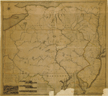
|
In: Christopher Colles, A survey of the roads.
Wheat: 334
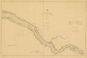
|
|
|
799.
From New York (9) to Poughkeepsie. [1789, 1961 reprint].
|
[1789]. |
Size: 17.2 x 11.5 cm.
|
(526.8: C68s) |
|
In: Christopher Colles, A survey of the roads.
Wheat: 335
|
|
|
800.
From New York (10) to Poughkeepsie. [1789, 1961 reprint].
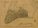
|
[1789]. |
Size: 17.2 x 11.4 cm.
|
(526.8: C68s) |
|
In: Christopher Colles, A survey of the roads.
Wheat: 336
|
|
|
801.
From New York (11) to Poughkee[p]sie. [1789, 1961 reprint].
|
[1789]. |
Size: 17.2 x 11.5 cm.
|
(526.8: C68s) |
|
In: Christopher Colles, A survey of the roads.
Wheat: 337
|
|
|
802.
From New York (12) to Poughkeepsie. [1789, 1961 reprint].
|
[1789]. |
Size: 16.7 x 11.3 cm.
|
(526.8: C68s) |
|
In: Christopher Colles, A survey of the roads.
Wheat: 338
|
|
|
803.
From New York (13) to Poughkeepsie. [1789, 1961 reprint].
|
[1789]. |
Size: 17.2 x 11.4 cm.
|
(526.8: C68s) |
|
In: Christopher Colles, A survey of the roads.
Wheat: 339
|
|
|
804.
From Poughkeepsie (14) to Albany. [1789, 1961 reprint].
|
[1789]. |
Size: 17.2 x 11.5 cm.
|
(526.8: C68s) |
|
In: Christopher Colles, A survey of the roads.
Wheat: 340
|
|
|
805.
From Poughkeepsie (21) to Albany. [1789, 1961 reprint].
|
[1789]. |
Size: 17 x 11.3 cm.
|
(526.8: C68s) |
|
In: Christopher Colles, A survey of the roads.
Wheat: 344
|
|
|
806.
From Poughkeepsie (22) to Albany. [1789, 1961 reprint].
|
[1789]. |
Size: 17.2 x 11.5 cm.
|
(526.8: C68s) |
|
In: Christopher Colles, A survey of the roads.
Wheat: 345
|
|
|
807.
From Poughkeepsie (23) to Albany. [1789, 1961 reprint].
|
[1789]. |
Size: 17.2 x 11.4 cm.
|
(526.8: C68s) |
|
In: Christopher Colles, A survey of the roads.
Wheat: 346
|
|
|
808.
From Poughkeepsie (24) to Albany. [1789, 1961 reprint].
|
[1789]. |
Size: 17.3 x 11.7 cm.
|
(526.8: C68s) |
|
In: Christopher Colles, A survey of the roads.
Wheat: 347
|
|
|
809.
From Poughkeepsie (25) to Albany. [1789, 1961 reprint].
|
[1789]. |
Size: 17.1 x 11.4 cm.
|
(526.8: C68s). |
|
In: Christopher Colles, A survey of the roads.
Wheat: 348
|
|
|
810.
From Stratford (18) to Poughkeepsie. [1789, 1961 reprint].
|
[1789]. |
Size: 17.1 x 11.3 cm.
|
(526.8: C68s) |
|
In: Christopher Colles, A survey of the roads.
Wheat: 341
|
|
|
811.
From Stratford (19) to Poughkeepsie. [1789, 1961 reprint].
|
[1789]. |
Size: 17.1 x 11.5 cm.
|
(526.8: C68s) |
|
In: Christopher Colles, A survey of the roads.
Wheat: 342
|
|
|
812.
From Stratford (20) to Poughkeepsie. [1789, 1961 reprint].
|
[1789]. |
Size: 17.1 x 11.5 cm.
|
(526.8: C68s) |
|
In: Christopher Colles, A survey of the roads.
Wheat: 343
|
|
|
813.
New York. Forts Erie, Schlosser, Niagara, Oswego and Schuyler are located. [1795].
|
[1795]. |
Scale: 2.5 cm. = 50 mi.
Size: 15.8 x 9.3 cm.
|
(Paine 68: Sco3u) |
|
In: Joseph Scott, The United States gazetteer, opposite "New-York." Incomplete.
Wheat: 366
Provenance:
Presented by the Estate of Richard Gimbel, 1974.
|
|
|
814.
New York. [1796].
Engraver:
W. Barker.
|
[1796]. |
Scale: 2.5 cm. = 60 mi.
Size: 14.6 x 19.3 cm.
|
(917.3: C25c) |
|
In: Mathew Carey, Carey's American pocket atlas, following p. 46.
Wheat: 367
Provenance:
Presented by Suzanne Wister Eastwick and Joseph L. Eastwick, July 1975.
|
|
|
815.
Map of Ontario and Steuben counties [1798].
Cartographer:
Heslop.
Engraver:
Fairman.
|
[1798]. |
Scale: 2.5 cm. = ca. 7 mi.
Size: 38 x 33.8 cm.
|
(974.7: W67d) |
|
In: Charles Williamson, Description of the settlement of the Genesee country, following p. 37.
Wheat: 376
|
|
|
816.
Map of Morris's purchase or West Geneseo in the state of New York. Exhibiting part of the Lakes Erie and Ontario, the straights of Niagara, Chautauque Lake and all the principal waters, the
boundary lines of the several tracts of lands purchased by the Holland Land Company, William and John Willink and others.
Boundary lines of townships: boundary lines of New York and Indian Reservations: laid down by actual survey; also a sketch
of part of Upper Canada. By Joseph & B. Ellicott. 1800. N.p.: 1800.
Cartographer:
Joseph & B. Ellicott.
|
[1800]. |
Size: 51.6 x 66.6 cm.; and 52.2 x 66.8 cm.
|
(647.934: 1800: EL52mpg Large) |
|
See: Ellis Paxson Oberholtzer, Robert Morris, patriot and financier. New York: Macmillan: 1903.
|
|
|
817.
The state of New-York from the best authorities. 1800.
Engraver:
A. Anderson.
|
1800. |
Scale: 2.5 cm. = ca. 38 American mi.
Size: 18.7 x 21.7 cm.
|
(910: P29) |
|
In: John Payne, A new and complete system of universal geography, vol. 4, opposite p. 296.
|
|
|
818.
A map of the state of New York. By Simeon De Witt. Albany: 1802 [16 October 1802].
Cartographer:
Simeon De Witt.
Engraver:
G. Fairman.
|
1802. |
Scale: 69 mi. = 1 degree.
Size: 167.5 x 133.7 cm.
|
(647: 1802: D512snn Large) |
|
Inset: Continuation of the state westward from the preemption line.
Provenance:
Presented by Simeon De Witt, 5 January 1827.
|
|
|
819.
Map of Morris's purchase or West Geneseo in the state of New York. Exhibiting part of the Lakes Erie and Ontario, the straights of Niagara, Chautauque Lake and all the principal waters, and
boundary lines of the several tracts of lands purchased by the Holland Land Company, William and John Willink and others.
Boundary lines of townships: boundary lines of New York and Indian Reservations: laid down by actual survey; also a sketch
of part of Upper Canada. By Joseph & B. Ellicott. 1804. N.p.: 1804.
Cartographer:
Joseph and B. Ellicott.
|
1804. |
Scale: 1¼ in. = 6 mi.
Size: 52.2 x 67 cm.
|
(647.934: 1804: EL52mpg Large) |
|
See: Ellis Paxson Oberholtzer, Robert Morris, patriot and financier. New York: Macmillan: 1903.
|
|
|
820.
A map of the state of New York. By Simeon De Witt. Contracted from his large map of the state 1804. New York: 1804 [19 March 1804].
Cartographer:
Simeon De Witt.
|
[19 March 1804]. |
Scale: 69 mi. = 1 degree.
Size: 55.4 x 69.3 cm.
Colored.
|
(647: 1804: D512sny Large) |
|
Mutilated: lower left corner is missing.
|
|
|
821.
A map shewing the relative situation of a tract of land belonging to I. B. Church Esqr. New York: 1804.
Cartographer:
Jos. Fra[?].
Engraver:
Peter Maverick.
|
1804. |
Scale: 1¾ in. = 40 mi.
Size: 38.9 x 48.6 cm.
|
(647: 1804: M455nys Small) |
|
822.
A map of the state of New York. Compiled from the latest authorities; including the turnpike roads now granted as also, the principal common roads connected
therewith. By William McCalpin. Oxford: 1808.
Cartographer:
William McCalpin.
|
1808. |
Scale: 69 mi. = 1 degree.
Size: 41.6 x 51.2 cm.
|
(647: 1808: M125mny Small) |
|
823.
Map of the northern part of the state of New York. Compiled from actual survey by Amos Lay. New York: 1812 [16 July 1812].
Cartographer:
Amos Lay.
|
1812. |
Scale: 1:443,520.
Size: 76.2 x 126.2 cm.
Colored.
|
(647: 1812: L455npn Large) |
|
824.
Plan of the siege of Plattsburg, and capture of the British fleet on Lake Champlain. The 11th Septr. 1814. [Philadelphia: ca. 1815].
Engraver:
B. Tanner.
|
1814. |
Size: 25 x 19.9 cm.
|
(647: 1814: T168psp Small) |
|
This is to accompany Tanner's engraving of MacDonough's victory on Lake Champlain, copied from the painting by Hugh Reinagle.
Provenance:
Presented by Henry Schenck Tanner, 20 February 1818.
|
|
|
825.
Map of the north west part of the state of New York. Compiled from original surveys, by P. Tardieu. Paris: 1816.
Cartographer:
P. Tardieu.
Engraver:
P. A. F. Tardieu and Richomme.
|
1816. |
Scale: 1 in. = 4½ mi.
Size: 59.6 x 72.9 cm.
Colored.
|
(647: 1816: Tl78sny Large) |
|
826.
Map of the Hudson between Sandy Hook and Sandy Hill with the post road between New York and Albany. New York: A. T. Goodrich and Co.: 1820.
Cartographer:
Bridges.
Engraver:
Rollinson.
|
1820. |
Size: 252.6 x 22.8 cm.
|
(647: 1820: G633hr Small) |
|
827.
Map and profile of the Erie Canal; commenced 1817, finished 1825. N.p.: [ca. 1825].
|
[ca. 1825]. |
Scale: 1 in. = 6 mi.
Size: 22.7 x 116.2 cm.
|
(647: [ca. 1825]: Er42ec Small) |
|
828.
Survey for a ship canal around the Falls of Niagara. Made and drawn under the direction of Capt. W. G. Williams . . . by Lts. T. F. Drayton and J. G. Reed. U.S. Topographical
Engineers. [Washington: 1835].
Cartographer:
W. G. Williams, T. F. Drayton, and J. G. Reed.
|
[1835]. |
Vertical scale: 50 ft. = 1 mi.
Size: 104.6 x 74.2 cm.
|
(647: [1835]: Un38cfn Large) |
|
Insets: Engraving of Niagara Falls; Niagara River; U.S. north of the Ohio River and Upper Canada; Mouth of Four Mile creek with
soundings adjacent.
Provenance:
Presented through J. R. Ingersoll, 15 July 1836.
|
|
|
829.
Survey for a ship canal to connect Lakes Erie, & Ontario. Lockport route. Profiles levelled and surveyed under the direction of Capt. W. G. Williams, U.S. Topographical Engineers,
assisted by Lieuts. Drayton and Reed. [Washington: 1835].
Cartographer:
W. G. Williams, T. F. Drayton, and J. G. Reed.
|
[1835]. |
Size of paper: 60.6 x 137.2 cm.
|
(647: [1835]: Un38cfn.l Large) |
|
See also map: 647: [1835]: Un38cfn Large.
|
|
|
830.
Survey for a ship canal to connect the Lakes Erie & Ontario. Lockport route. Surveyed under the direction of Capt. W. G. Williams by Lieuts. T. F. Drayton and J. G. Reed. U.S. Topographical
Engineers. Map no. 3. [Washington: 1835].
Cartographer:
W. G. Williams, T. F. Drayton, and J. G. Reed.
|
[1835]. |
Scale: 4 in. = 5280 ft.
Size: 128.1 x 69.7 cm.
|
(647: [1835]: Un38eop Large) |
|
Inset: Tonnawanta Creek from the Niagara River.
Provenance:
Presented by W. G. Williams through J. R. Ingersoll, 15 July 1836.
|
|
|
831.
Survey for a ship canal around the Falls of Niagara. Made and drawn under the direction of Capt. W. G. Williams, U.S.T. Engineers by Lts. T. F. Drayton and J. G. Reed. U.S. Army
Topographical Engineers. N.p.: [1836].
Cartographer:
W. G. Williams, T. F. Drayton, and J. G. Reed.
|
[1836]. |
Scale: 12 in. = 1 mi. (horizontal).
Size: 104.6 x 74.2 cm.
|
(647: [1836]: W678scn Large) |
|
Insets: Niagara River segments; Mouth of Four Mile Creek; Great Lakes and St. Lawrence River to Quebec.
With this are: 1) Profiles of the survey around Niagara Falls. Nos. 1, 2, 3.Sizes: various. 2) Plan of an artificial harbor & project for descent of ridge.Insets: Termination of line; and Section of lock.Size: 73 x 117.4 cm.
Provenance:
Presented by J. R. Ingersoll, 15 July 1836.
|
|
|
832.
Oyster or Syosset Bay. Harbor of refuge no. [blank]. Founded upon a trigonometrical survey under the direction of F. R. Hassler. U.S. Coast and Geodetic Survey. [Washington]:
1847.
Cartographer:
F. R. Hassler, E. Blunt, A. D. MacKay, F. H. Gerdes, G. S. Blake, and John B. Glück.
Engraver:
Sherman and Smith.
|
1847. |
Scale: 1:30,000.
Size: 43.7 x 35.6 cm.
|
(647: 1847: Un31oyb Small) |
|
833.
Huntington Bay. Founded upon a trigonometrical survey under the direction of F. R. Hassler. U.S. Coast and Geodetic Survey. [Washington]:
1849.
Cartographer:
F. R. Hassler, E. Blunt, F. H. Gerdes, G. S. Blake, and J. B. Glück.
Engraver:
George G. Smith.
|
1849. |
Scale: 1:30,000.
Size: 35.8 x 43.8 cm.
|
(647: 1849: Un33hb Small) |
|
834.
Chart of Buffalo harbor and head of Niagara River, with the outlet of Lake Erie. U.S. Bureau of Topographical Engineers. From the surveys of Capt. W. G. Williams. [Washington]: 1856.
Cartographer:
W. G. Williams and I. C. Woodruff.
Engraver:
W. H. Dougal.
|
1856. |
Scale: 1:30,000.
Size: 54.5 x 50.1 cm.
|
(647.919: 1856: Un38cbh Large) |
|
835.
New York. [From: Atlas of the world, p. 16]. Rand, McNally & Co.: 1898.
|
1898. |
Scale: 1 in. = 28 mi.
Size: 23.5 x 31.7 cm.
Colored.
|
(647: 1898: N429Lis Small) |
|
Inset: Long Island and lower part of New York state.
On same sheet is: Connecticut, Atlas of the world. 1898.
Provenance:
Presented by Mrs. A. I. Hallowell, November 1983.
|
|
|
836.
Geologic map of New York, exhibiting the structure of the state so far as known. By Frederick J. H. Merrill. University of the State of New York. New York State Museum. New York: James B. Lyon, state printer,
and Julius Bien & Co.: 1901. 12 sheets and wrapper.
Cartographer:
F. J. H. Merrill.
|
1901. |
Scale: 1 in. = 5 mi.
Size: ca. 52.5 x 42.5 cm.
Colored.
|
(647: 1901: N486geo Large) |
|
837.
Niagara River and vicinity. U.S. Geological Survey. Charles D. Walcott, director. [Washington]: 1901.
Cartographer:
Henry Gannett, H. M. Wilson, Charles D. Walcott, Frank Sutton, J. H. Wheat, and W. W. Gilbert.
|
1901. |
Scale: 1:62,500.
Size: 89.4 x 34 cm.
Colored.
|
(647: 1901: Un38nrv Large) |
|
838
Albany and vicinity, New York. U.S. Geological Survey. Charles D. Walcott, director. Surveyed in 1891-1892 in cooperation with the State of New York. [Washington]:
1902. Edition of March 1902.
Cartographer:
C. D. Walcott, Henry Gannett, H. M. Wilson, Frank Sutton, and J. H. Jennings.
|
1902. |
Scale: 1:62,500.
Size: 91.7 x 68.6 cm.
Colored.
|
(647.912: 1902: Un38aav Large) |
|
839.
Correlation of the Cambrian rocks in New York state by Donald W. Fisher, state paleontologist. Geologic survey of the State Museum and Science Service, State Education Department of the University of the State of New
York. Geological survey by John G. Broughton, state geologist. Albany: 1962. Map and chart series, no. 2, 1962.
Cartographer:
Donald W. Fisher and John G. Broughton.
|
1962. |
Size of paper: 89 x 114.4 cm.
|
(647: 1962: N486cam Small) |
|
840.
Geological map of New York; 1961. University of the State of New York. State Education Department. State Museum and Science Service. Geological Survey map
and chart series nos. 5 and 15. Albany: 1962.
|
1962. |
16 pieces.
Sizes: various.
Colored.
|
(647: 1961: N486umg Extra-oversize) |
|
841.
Simple Bouguer gravity anomaly map of western New York. [Covers area of Niagara and Finger Lakes sheets of the 1961 and 1970 editions of the Geological Map of New York.] By Frank
A. Revetta and William D. Diment. New York State Museum and Science Service. Geological Survey maps and charts series no.
17. The University of the State of New York. The State Education Department. Compiled 1971.
Cartographer:
Frank A. Revetta and William D. Diment.
|
1971. |
Scale: 1:250,000.
Size: 87.7 x 150.5 cm.
|
(647: 1971: R328bga Large) |
|
842.
Preliminary brittle structure map of New York. Yngvar W. Isachsen and William G. McKendree. New York State Museum. Map and chart series nos. 31 a-g. Geological Survey of
New York. The University of the State of New York. The State Education Department. [Albany, N.Y.]: 1974-1977.
Cartographer:
Yngvar W. Isachsen and William G. McKendree.
|
1974-1977 |
Colored.
|
(647: 1974-1977: Is11bsm Large) |
|
31a. Adirondack sheet.Scale: 1:250,000. Size: 72.1 x 110 cm.
31b. Hudson-Mohawk sheet.Scale: 1:250,000. Size: 72.5 x 112.5 cm.
31c. Lower Hudson.Scale: 1:250,000. Size: 73.5 x 32.2 cm.
31d. Niagara-Finger Lakes sheet.Scale: 1:250,000. Size: 76 x 114.5 cm.
31e. Preliminary brittle structure map of New York.Scale: 1:250,000. Size: 104.8 x 140.4 cm.
31f. Generalized map of recorded joint systems in New York.Scale: 1:1,000,000. Size: 51.9 x 67.8 cm.
31g. Sources of information for preliminary brittle structures map of New York and generalized map of recorded joint system
in New York.Scale: 1:250,000. Size: 67.8 x 51.8 cm.
|
|
|
843.
Quaternary geology of New York, Niagara sheet. By Ernest H. Muller. New York State Museum and Science Service. Geological Survey map and chart series number 28. [Albany,
N.Y]: 1977.
Cartographer:
Ernest H. Muller.
|
1977. |
Scale: 1:250,000.
Size: 74.9 x 77 cm.
Colored.
|
(647: 1977: M918qni Large) |
|
Inset: Moraines of western New York.
|
|
|
New York City
|
|
|
|
|
844.
Map of the ground occupied as a botanic garden, the property of Dr. Hosack, situate on the west side of the Middle Road, New
York. Surveyed January 1810 by Wm. Bridges.
Cartographer:
William Bridges.
|
1810. |
Size: 9.7 x 32.5 cm.
|
(B: H78.r) |
|
Original in Columbia University; this photograph from published copy on file in the office of the Secretary of State of New
York, Charters . . . , vol. 39, p. 82.
Provenance:
Presented by Mrs. Caroline Robbins, 16 November 1965.
|
|
|
845.
Plan of the city of New York. Drawn and engrav'd for D. Longworth, map and print seller. [New York]: D. Longworth: [ca. 1830].
Cartographer:
J .A.
Engraver:
P. R. Maverick.
|
[ca. 1830]. |
Scale: 1 in. = 1000 ft.
Szie: 37.9 x 55 cm.
|
(647.957: [ca. 1830]: M455pny Small) |
|
Provenance:
Presented by Daniel Parker, 4 January 1833.
|
|
|
846.
City of New York. New York: J. H. Colton & Co.: 1834.
Engraver:
S. Stiles & Co.
|
1834. |
Size: 54.2 x 44 cm.
Colored.
|
(647.957: 1834: B94c Book map) |
|
847.
Map of New-York bay and harbor and the environs. Founded upon a trigonometrical survey under the direction of F. R. Hassler. U.S. Coast Survey. [Washington]: 1844.
Cartographer:
F. R. Hassler, James Ferguson, Edmund Blunt, Thomas R. Gedney, C. Renard, and T. A. Jenkins.
|
1844. |
Scale: 1:31,680.
Size: 167.1 x 160.7 cm.
|
(647: 1844: Un38nyb Large) |
|
848.
Map of New-York bay and harbor and the environs. Founded upon a trigonometrical survey under the direction of F. R. Hassler. U.S. Coast Survey. [Washington]: 1845.
Cartographer:
F. R. Hassler, James Ferguson, Edmund Blunt, C. Renard, T. A. Jenkins, and B. F. Sands.
Engraver:
S. Siebert, A. Rollé, O. A. Lawson, F. Dankworth, and J. Knight.
|
1845. |
Scale: 1:84,480.
Size: 62.7 x 89.6 cm.
|
(647: 1845: Un38nyh Large) |
|
849.
Hart & City Island. [And] Sachem's Head Harbor. From a trigonometrical survey under the direction of A. D. Bache. U.S. Coast and Geodetic Survey. [Washington]: 1851. 2 maps
on 1 sheet.
Cartographer:
A. D. Bache, E. Blunt, T. W. Werner, H. L. Whiting, G. S. Blake, J. R. Goldsborough, M. McClery, J. Lambert, and J. Robertson.
Engraver:
R. T. Knight and S. T. Pettit.
|
1851. |
Scale: 1:20,000 and 1:10,000.
Size: 35.7 x 43.7 cm.
|
(647: 1851: Un33hcsh Small) |
|
850.
Hell Gate and its approaches. From a trigonometrical survey under the direction of F. R. Hassler and A. D. Bache. U.S. Coast Survey. [Washington]: 1851.
Cartographer:
F. R. Hassler, A. D. Bache, Edmund Blunt, H. L. Whiting, D. D. Porter, M. Woodhull, C. Mahon, and J. R. P. Mechlin.
Engraver:
A. Rollé, F. Dankworth, G. McCoy, and J. Knight.
|
1851. |
Scale: 1:5,000.
Size: 62.4 x 89.3 cm.
|
(647: 1851: Un38hga Large) |
|
851.
Western part of the southern coast of Long Island. From a trigonometrical survey under the direction of F. R. Hassler and A. D. Bache. U.S. Coast Survey. [Washington]: 1851.
Cartographer:
: F. R. Hassler, A. D. Bache, Edmund Blunt, C. Renard, H. L. Dickens, T. R. Gedney, R. Bache, A. S. Baldwin, M. Woodhull,
F. H. Gerdes, and J. J. Ricketts.
Engraver:
F. Dankworth, O. A. Lawson, and J. Knight.
|
1851. |
Scale: 1:80,000.
Size: 62.5 x 89.3 cm.
|
(647: 1851: Un38sLi Large) |
|
852.
Map of New York bay and harbor. John Hill in 1778, J. F. W. Des Barres in 1779, Capt. Leconte in 1819. U.S. Coast Survey. Philadelphia: Wagner & McGuigan,
lith.: 1853.
Cartographer:
John Hill, J. F. W. Des Barres, and Capt. Leconte.
Engraver:
Wagner & McGuigan.
|
1853. |
Size: 52.7 x 42.6 cm.
|
(647: 1853: Un38Lec Small) |
|
853.
Preliminary chart of New York bay and harbor. From a trigonometrical survey under the direction of A. D. Bache. U.S. Coast Survey. New York: Hatch & Co.: 1857.
Cartographer:
A. D. Bache, J. Ferguson, E. Blunt, S. A. Gilbert, A. S. Wadsworth, A. M. Harrison, H. Adams, H. L. Whiting, R. Wainwright,
T. A. Craven, W. G. Temple, and A. Balbach.
|
1857. |
Scale: 1:80,000.
Size: 77 x 67.5 cm.
|
(647: 1857: Un38pcy Large) |
|
854.
Bay and harbor of New York. U.S. Coast and Geodetic Survey. [Washington]: 1874.
Cartographer:
J. Ferguson, E. Blunt, H. L. Whiting, S. A. Gilbert, A. M. Harrison, F. H. Gerdes, A. Boschke, F. W. Dorr, C. Rockwell, J.
Mechan, R. Wainwright, T. A. Craven, H. Mitchell, and F. F. Nes.
Engraver:
E. Molkow, W. A. Thompson, R. F. Bartle, H. C. Evans, H. M. Knight, E. A. Maedel, H. Lindenkohl, and A. Lindenkohl.
|
1874. |
Scale: 1:40,000.
Size: 121.9 x 99.7 cm.
|
(647: 1874: Un38bhy Large) |
|
855.
Central Park, New York City. Official map. By the courtesy of the Department of Parks of the City of New York. N.p.: [ca. 1885].
|
[ca. 1885] |
Size of paper: 42.2 x 187.2 cm.
|
(647.957: [ca. 1885]: N426cen Small) |
|
856.
New York City and vicinity. U.S. Geological Survey. Charles D. Walcott, director. [Washington]: 1901. Edition of January 1901.
Cartographer:
H. M. Wilson and C. D. Walcott.
|
1901. |
Scale: 1:62,500.
Size: 114.3 x 83.4 cm.
Colored.
|
(647.957: 1901: Un38nyc Large) |
|
857.
Map of New York City. Directory Office. New York: [ca. 1905].
Engraver:
Fisk and Rusell.
|
[ca. 1905]. |
2 pieces.
Scale: 1 in. = ¾ mi.
Size: 19.8 x 50.5 cm.
|
(647.957: [ca. 1905]: F523nyc Small) |
|
New Jersey
|
|
|
|
|
858.
A mapp of New Jersey in America, by John Seller and William Fisher. London: Seller and Fisher: 1677.
Cartographer:
Seller and Fisher.
|
1677. |
Scale: 1:2 English leagues.
Size: 43.5 x 92.3 cm.
Colored.
|
(648: 1677: Se57rnj Large) |
|
Inset: New York [City].
Reproduced in collotype by the Meriden Gravure Company, 1958.
|
|
|
859.
[Map of New Jersey north of the Raritan River to the North Mountain. 1747].
Cartographer:
Lewis Evans (?).
Engraver:
James Turner.
|
[1747]. |
Scale: 2.5 cm. = 5 mi.
Size of plate: 28.3 x 61.5 cm.
|
(347.8: N46b) |
|
In: Board of General Proprietors of the Eastern Division of New Jersey. A bill in the chancery of New Jersey, following p. 124.
Wheat: 397
|
|
|
860.
[Map of the northern parts of New Jersey and the adjacent parts of New York. 1747].
Cartographer:
Lewis Evans.
Engraver:
James Turner.
|
[1747]. |
Scale: 2.5 cm. = 150 chains.
Size of plate: 42.5 x 34.5 cm.
|
(347.8: EN46b) |
|
In: Board of general proprietors of the eastern division of New Jersey. A bill in the chancery of New Jersey, following p. 124.
Wheat: 398
|
|
|
861.
The province of New Jersey, divided into east and west, commonly called the Jerseys. Second edition with considerable improvements. This map has been drawn from the surveys made in 1769 by order of the commissioners
appointed to settle the partition line between the provinces of New York & New Jersey by Bernard Ratzer . . . and from another
large survey of the northern parts . . . by Gerard Ban[c]ker . . . In this second edition great use has been made of several
military surveys generously communicated by the officers of the British troops and of the regiments of Hesse and Anspach.
[London]: W. Faden: 1778 [1 December 1778].
Cartographer:
Bernard Ratzer, Gerard Bancker, and W. Faden.
Engraver:
W. Faden.
|
[1 December 1778]. |
Scale: 1 degree = ca. 69½ British mi.
Size: 78 x 56.6 cm.
Colored.
|
(648: 1778: F123jer Large) |
|
Facsimile made from a fine hand-colored copy of the 1778 map in the Ely Collection of the New Jersey Historical Society .
. . printed in six colors on hand-fashioned paper by the Historic Publication Company of Montclair, New Jersey, from plates
made for this edition in Milan, Italy.
|
|
|
862.
New and accurate map of New Jersey, from the best authorities. [London: J. Hinton: 1780].
|
[1780]. |
Size: 31.5 x 26.6 cm.
|
(648: [1780]: N426nj Small) |
|
From Universal Magazine. London: John Hinton: 1780. June 1780, vol. 66, p. 281.
|
|
|
863.
From New-York (40) to Elizabeth Town. [1789, 1961 reprint].
|
[1789]. |
Size: 17 x 11.5 cm.
|
(526.8: C68s, and Pam., vol. 349, no. 4) |
|
In: Christopher Colles, A survey of the roads; also Christopher Colles, The geographical ledger and systematized atlas.
Wheat: 401
|
|
|
864.
From New-York (41) to Brunswick. [1789, 1961 reprint].
|
[1789]. |
Size: 17.1 x 11.6 cm.
|
(526.8: C68s, and Pam., vol. 349, no. 4) |
|
In: Christopher Colles, A survey of the roads; also Christopher Colles, The geographical ledger and systematized atlas.
Wheat: 402
|
|
|
865.
From New-York (42) to Brunswick. [1789, 1961 reprint].
|
[1789]. |
Size: 17 x 11.3 cm.
|
(526.8: C68s, and Pam., vol. 349, no. 4) |
|
In: Christopher Colles, A survey of the roads; also Christopher Colles, The geographical ledger and systematized atlas.
Wheat: 403
|
|
|
866.
From New-York (43) to Kingston. [1789, 1961 reprint].
|
[1789]. |
Size: 17.1 x 11.6 cm.
|
(526.8: C68s, and Pam., vol. 349, no. 4) |
|
In: Christopher Colles, A survey of the roads; also Christopher Colles, The geographical ledger and systematized atlas.
Wheat: 404
|
|
|
867.
From New-York (44) to Trenton. [1789, 1961 reprint].
|
[1789]. |
Size: 17.3 x 11.3 cm.
|
(526.8: C68s, and Pam., vol. 349, no. 4) |
|
In: Christopher Colles, A survey of the roads; also Christopher Colles, The geographical ledger and systematized atlas.
Wheat: 405
|
|
|
868.
From New-York (45) to Bristol. [1789, 1961 reprint].
|
[1789]. |
Size: 17.2 x 11.6 cm.
|
(526.8: C68s, and Pam., vol. 349, no. 4) |
|
In: Christopher Colles, A survey of the roads; also Christopher Colles, The geographical ledger and systematized atlas.
Wheat: 406
|
|
|
869.
From New-York (45*) to Cranberry. [1789, 1961 reprint].
|
[1789]. |
Size: 17.2 x 11.6 cm.
|
(526.8: C68s) |
|
In: Christopher Colles, A survey of the roads.
Wheat: 407
|
|
|
870.
From New-York (46*) to Allen town. [1789, 1961 reprint].
|
[1789]. |
Size: 17.2 x 11.5 cm.
|
(526.8: C68s) |
|
In: Christopher Colles, A survey of the roads.
Wheat: 408
|
|
|
871.
From New-York (47*) to the Blackhorse. [1789, 1961 reprint].
|
[1789]. |
Size: 17.1 x 11.5 cm.
|
(526.8: C68s) |
|
In: Christopher Colles, A survey of the roads.
Wheat: 409
|
|
|
872.
From New-York (48) to Mount Holly. [1789, 1961 reprint].
|
[1789]. |
Size: 17.3 x 11.6 cm.
|
(526.8: C68s) |
|
In: Christopher Colles, A survey of the roads.
Wheat: 410
|
|
|
873.
From New-York (49) to Philadelphia. [1789, 1961 reprint].
|
[1789]. |
Size: 17.2 x 11.6 cm.
|
(526.8: C68s) |
|
In: Christopher Colles, A survey of the roads.
Wheat: 411
|
|
|
874.
From New-York (50) to Philadelphia. [1789, 1961 reprint].
|
[1789]. |
Size: 17.2 x 11.5 cm.
|
(526.8: C68s) |
|
In: Christopher Colles, A survey of the roads.
Wheat: 412
|
|
|
875.
New Jersey. [1795].
|
[1795]. |
Scale: 2.5 cm. = I6½ mi.
Size: 18.4 x 15.3 cm.
|
(Paine 86: Sco3u) |
|
In: Joseph Scott, The United States gazetteer, opposite "Jersey."
Wheat: 415
Provenance:
Presented by the Estate of Richard Gimbel, 1974.
|
|
|
876.
New Jersey. [1796].
Engraver:
A. Doolittle.
|
[1796]. |
Scale: 2.5 cm. = 25 American mi.
Size: 19.1 x 14.4 cm.
|
(917.3: C25c) |
|
In: Mathew Carey, Carey's American pocket atlas, following p. 52.
Wheat: 416
Provenance:
Presented by Suzanne Wister Eastwick and Joseph L. Eastwick, July 1975.
|
|
|
877.
State of New Jersey. [ 1799].
Engraver:
W. Barker.
|
[1799]. |
Size: 27.3 x 18.7 cm.
|
(910: P29) |
|
In: John Payne, A new and complete system of universal geography, vol. 4, opposite p. 320.
Wheat: 420
|
|
|
878.
The Morris canal route. N.p.: [ca. 1820].
Engraver:
J. A. Adams.
|
[ca. 1820]. |
Scale: 2 cm. = 3 mi.
Size: 18.5 x 42.4 cm.
|
(648: [ca. 1820]: Ad11mcr Small) |
|
879.
A map of the state of New Jersey with part of adjoining states. Compiled under the patronage of the legislature of said state by Thomas Gordon. 1828. Trenton: Gordon: 1828 [20 March 1828].
Cartographer:
Thomas Gordon.
Engraver:
H. S. Tanner.
|
1828. |
Scale: 1:190,080.
Size: 141 x 83 cm.
Colored.
|
(648: 1828: G653snt Large) |
|
880.
Cape May roads, including Crow Shoal, Del[aware] Bay (September, 1836) and shewing the plan of an artificial harbor proposed
for that place. U.S. Topographical Engineers. [Washington]: 1838.
Cartographer:
Hartman Bache.
Engraver:
William J. Stone.
|
1836. |
Scale: 6 in. = 1 mi.
Size: 65 x 113.4 cm.
|
(648: 1836: Un38cmr Large) |
|
See: U.S. 25th Congress. 2nd Session. Document no. 155.
Provenance:
Presented and endorsed by Hartman Bache, 26 June 1838.
|
|
|
881.
Little Egg Harbor. Founded upon a trigonometrical survey under the direction of F. R. Hassler. U.S. Coast and Geodetic Survey. [Washington]: 1846.
Cartographer:
F. R. Hassler, C. Renard, G. M. Bache, B. F. Sands, and M. I. McClery.
Engraver:
O. A. Lawson and J. Knight.
|
1846. |
Scale: 1:30,000.
Size: 44 x 35.8 cm.
|
(648: 1846: Un33Leh Small) |
|
882.
Coast chart no. 22. From Barnegat Inlet to Absecon Inlet, New Jersey. U.S. Coast and Geodetic Survey. [Washington]: 1879.
Cartographer:
C. Renard, J. Farley, F. W. Perkins, Charles M. Bache, H. M. De Wees, T. R. Gedney, T. S. Phelps, J. F. Moser, W. I. Vinal,
C. Fendall, W. W. Harding, T. J. Lee, C. A. Schott, A. Lindenkohl, W. Lindenkohl, and C. Junken.
Engraver:
H. C. Evans, E. A. Maedel, and F. Courtenay.
|
1879. |
Scale: 1:80,000.
Size: 96.8 x 77.4 cm.
|
(648: 1879: Un38bai Large) |
|
Inset: Diagram of charts of the New Jersey shoreline.
Provenance:
Presented by the U.S. Coast and Geodetic Survey through Spencer C. McCorkle, 14 December 1885.
|
|
|
883.
Cape May city and vicinity, New Jersey. U.S. Coast and Geodetic Survey. Surveyed by C. M. Bache . . . during the summer of 1879. [Washington]: 1880.
Cartographer:
C. M. Bache.
|
1880. |
Scale: 1:10,000.
Size: 59.5 x 97.2 cm.
|
(648: 1880: Un38cmc Large) |
|
884.
A topographical map of a part of northern New Jersey. Geological Survey of New Jersey. From surveys and levelings made and local surveys corrected by Geo. W. Howell and C. C. Vermeule, upon a projection made
by the U.S. Coast and Geodetic Survey. [New York]: J. Bien: 1882.
Cartographer:
George W. Howell and C. C. Vermeule.
Engraver:
Julius Bien.
|
1882. |
Scale: 1:63,360.
Size: 89.6 x 90.1 cm.
Colored.
|
(648: 1882: N466nnj Large) |
|
Letter from H. B. Kümmel identifies the map as a preliminary edition which is not in the New Jersey collection; 28 February
1903.
|
|
|
885.
Coast chart no. 21. From Sandy Hook to Barnegat Inlet, New Jersey. U.S. Coast and Geodetic Survey. Aids to navigation corrected to 1885. [Washington]:
1885.
Cartographer:
E. Blunt, C. Renard, J. Ferguson, J. Farley, W. S. Edwards, A. T. Mosman, F. W. Perkins, C. M. Bache, A. M. Harrison, Thomas
R. Gedney, Geo. M. Bache, J. F. Moser, C. Fendall, W. I. Vinal, J. Renwick, C. A. Schott, T. C. Hilgard, H. Lindenkohl, P.
Erichsen, and A. Lindenkohl.
Engraver:
H. C. Evans, W. A. Thompson, J. G. Thompson, E. A. Maedel, and F. Courtenay.
|
1885. |
Scale: 1:80,000.
Size: 97.9 x 76.1 cm.
|
(648: 1885: Un38shb Large) |
|
Inset: Diagram of charts of the New Jersey shoreline.
Provenance:
Presented by the U.S. Coast and Geodetic Survey through Spencer C. McCorkle, 14 December 1885.
|
|
|
886.
Atlas of New Jersey. Geological Survey of New Jersey. George H. Cook, state geologist; John C. Smock, assistant geologist; and, C. Clarkson Vermeule,
topographer. New York: J. Bien, lith.: 1887-1889.
Cartographer:
George H. Cook, John C. Smock, and C. Clarkson Vermeule.
|
1887-1889. |
Scale: 1 in. = 1 mi.
Size: ca. 88 x 62 cm.
Colored.
|
(648: 1887-1889: N466geo Large) |
|
1. Kittatinny valley & mountain. 2. Southwestern highlands. 3. Central highlands. 4. Northeastern highlands. 5. Vicinity of
Flemington. 6. The valley of the Passaic. 7. Counties of Bergen, Hudson & Essex. 8. Vicinity of Trenton. 9. Monmouth shore.
10. Vicinity of Salem. 11. Vicinity of Camden. 12. Vicinity of Mount Holly. 13. Vicinity of Barnegat Bay. 14. Vicinity of
Bridgeton. 15. Southern interior. 16. Egg Harbor and vicinity. 17. Peninsula of Cape May. 18. State map of New Jersey, geographic.
19. Relief map of New Jersey. 20. Geological map of New Jersey. 21-38. Atlas sheets 21-28, 31-33, 35-38 with original wrapper.
|
|
|
887.
Map of Newbold, New Jersey. Laid out by Fowler and Lummis for Newbold Improvement Company. Philadelphia: F. Bourquin: 1887.
Cartographer:
Fowler and Lummis.
Engraver:
F. Bourquin.
|
1887. |
Scale: 1 in. = 200 ft.
Size: 64.7 x 57.8 cm.
Colored.
|
(648.957: 1887: N426mnb Small) |
|
888.
New Jersey. Bordentown sheet. U.S. Geological Survey. J. W. Powell, director. Surveyed in 1885. Edition of September 1893. [Washington]:
1893.
Cartographer:
J. W. Powell, Henry Gannett, George H. Cook, and C. C. Vermeule.
|
1893. |
Scale: 1:62,500.
Size: 44.5 x 34.2 cm.
Colored.
|
(648: 1893: Un33bs Small) |
|
889.
Relief map of New Jersey, 1896. Geological Survey of New Jersey. John C. Smock, state geologist. Based upon the topographical survey. N.p.: 1896. Name sheet
in three pieces.
Cartographer:
John C. Smock and C. C. Vermeule.
|
1896. |
Scale: 1 in. = 4 mi.
Size: 110 x 61.8 cm.
Colored.
|
(648: 1896: N466ref Large) |
|
890.
[Geologic and topographic maps of New Jersey]. Geological survey of New Jersey. John C. Smock, state geologist. C. C. Vermeule, topographer. Surveyed in 1884-1887. [Trenton?]:
1899-1902. Edition of 1899-1902.
Cartographer:
John C. Smock and C. C. Vermeule.
|
1899-1902. |
Scale: 6.5 cm. = ½ mi.
Colored.
|
(648: 1899-1902: N466top Large) |
|
1. Taunton. 54 x 77.6 cm. 2. Amboy. 54 x 76.7 cm. 3. Navesink. 54 x 76.8 cm. 4. Long Branch. 54 x 76.9 cm. 5. Trenton. 54
x 77 cm. 6. Atlantic City. 54 x 78 cm. 7. New York Bay. 54 x 76.5 cm. 8. Shark River. 54 x 76.9 cm. 9. Jersey City. 54 x 76.5
cm. 10. Newark. 54.2 x 76.2 cm. 11. Morristown. 54 x 76.2 cm. 12. Hackensack. 54.2 x 76.6 cm. 13. Paterson. 54 x 76.2 cm.
14. Elizabeth. 54 x 76.4 cm. 15. Plainfield. 54 x 76.4 cm. 16. Camden. 54 x 77.3 cm. 17. Mount Holly. 54 x 77.3 cm. 18. Woodbury.
54 x 77.3 cm.
|
|
|
891.
New Jersey showing forest area and its relation to the principal watersheds. Geological Survey of New Jersey. John C. Smock, state geologist. C. C. Vermeule, topographer. [Trenton]: 1900.
Cartographer:
John C. Smock and C. C. Vermeule.
|
1900. |
7 sheets.
Scales: 1 in. = 5 mi., and 1 mi.
Sizes: Various.
Colored.
|
(648: 1900: N466for Large) |
|
See: New Jersey. Geological Survey. Forests of New Jersey, Annual report.1900.
|
|
|
892.
[Geological Survey of New Jersey]. Geological Survey of New Jersey. Henry B. Kümmel, state geologist. C. C. Vermeule, topographer. Surveyed in 1881-1883-1886-1887.
Resurvey in 1904. N.p.: [ca. 1905]. Edition of 1905.
Cartographer:
Henry B. Kümmel and C. C. Vermeule.
|
[ca. 1905]. |
6 sheets.
Scale: 5¼ in. = 2 mi.
|
(648: [ca. 1905]: N466gsj Large) |
|
1. Dover-Stanhope. 54 x 76.2 cm. 2. Boonton. 54 x 76.2 cm. 5. Chester. 54 x 76.3 cm. 9. Pluckemin. 54 x 76.6 cm. 13. Somerville.
54 x 76.6 cm. 14. New Brunswick. 54 x 76.6 cm.
|
|
|
893.
New Jersey. Sheet 32. Department of Conservation and Economic Development. Topographic Service. [1955].
Cartographer:
C. C. Vermeule and R. G. Blanchard.
|
[1955]. |
Scale: 1 in. = 1 mi.
Size: 83.6 x 60.6 cm.
Colored.
|
(648: [1955]: V591ccd Small) |
|
894.
Plan of Barnegat City, situated at Barnegat Inlet, Long Beach, N[ew] J[ersey]. [Camden, N.J.]: W. T. Bailey & Bro.: n.d.
|
[n.d.]. |
Size: 49.3 x 83.7 cm.
|
(648: [n.d.]: P376pbc Large) |
|
Inset: Picture of Barnegat lighthouse, bay, and inlet.
|
|
|
Pennsylvania
|
|
|
|
|
895.
Nova Suecia; eller the Swenska Revier [now Delaware River] in India Occidentalis. Drawn by Peter Lindeström, Royal Swedish Engineer, 1654 & 1655.
Cartographer:
Peter Lindeström.
|
[1654/55]. |
Scale: Milm. Germm. 15 in uno Gradu.
Size: 14.2 x 60.4 cm.
|
(635: [1654/55]: L645nso Large) |
|
Reproduction of manuscript in Royal Swedish Archives. Size of original: 14.4 x 70 cm.
|
|
|
896.
Nova Suecia hodie dicta Pennsylvania Anno 1654 och 1655. Ar denna Nova Sueciae carta med dess riviers och lande situation, ock Beskaffenhet oftagen och tilt carts fôrd af P. Lindeström.
[Philadelphia: 1834].
Cartographer:
P. Lindeström.
Engraver:
Fortif.
|
[1654/55]. |
Size: 26.4 x 12.8 cm.
|
(649: [1654/55]: L645ns Small) |
|
Original map in Campanius Holm, Kort beskrifning om provincien Nya Swerige uti America. . . . Stockholm: Wankijfs: 1702.
This is a duplicate of the map in Historical Society of Pennsylvania, Memoirs, vol. 3, p. 46, 1834.
|
|
|
897.
Map of the improved part of the province of Pennsilvania containing the three countyes of Chester, Philadelphia & Bucks as
far as yet surveyed & laid out; ye divisions or distinctions made by ye different coullers, respects the settlements by way
of townships. By Thomas Holme. London: Green & Thornton: [1687].
Cartographer:
Thomas Holme.
Engraver:
F. Lamb.
|
[1687]. |
Scale: 4 English mi. or 32 furlongs.
Size: 82 x 140.5 cm.
|
(649: [1687]: H733pen Framed. In map and print room) |
|
Inset: City of Philadelphia.
Provenance:
Presented by John Thornton and Robert Greene, mapsellers, London, 21 May 1824.
|
|
|
898.
Novae Sueciae tabula, ex Nic. Visscheri, del. [Stockholm?: 1702?].
Cartographer:
Nikolaes Jamsz Visscher II.
|
[1702?]. |
Size: 13.1 x 8.2 cm.
Size of paper: 21.7 x 28.7 cm.
|
(640.2: [1702?]: V828ns Small) |
|
Original in: Thomas Campanius Holm, Kort beskrifning om provincien Nya Swerige. Stockholm: S. Wankijfs: 1702. P. 26.
Contains also a drawing of Trinity Fort.
See Historical Society of Pennsylvania, Memoirs, vol. 3, p. 78.
|
|
|
899.
Plot of adjusted survey [of] Moravian road: Authorized: Court of Quarter-Sessions, New Town, June 11, 1747.
Cartographer:
Thomas Craig, George Gray, and Robert Greeg.
|
1747. |
Size: 26 x 34.4 cm.
|
(649: 1747: P376mor Small) |
|
Photostat.
Report of survey, 9 March 1748: "From the kings road near Bethlehem to the Mahoning Creek passing near the Healing Waters beyond the Blue Mountain." See: Northampton County Historical and Genealogical Society. Publications, vol. 2. "The Penn patents in the Forks of the Delaware."
See: "Independent conformation of the magnetic declination 1737-1748" by John Robert Connelly [Palmerton, Pa.: 1963].
Provenance:
Presented by John Robert Connelly, December 1964.
|
|
|
900.
To the Honorable Thomas Penn and Richard Penn . . . map of the improved part of the province of Pennsylvania. By Nicholas Scull. Philadelphia: John Davis: 1759 [1 January 1759].
Cartographer:
Nicholas Scull.
Engraver:
J. Turner.
|
1759. |
Scale: 69½ British mi. = 1 degree.
Size: 76.5 x 152.6 cm.
Colored.
|
(649: 1759: Scu47tr Large) |
|
Wheat: 422
Provenance:
Presented by John Vaughan, 17 January 1806.
|
|
|
901.
Plan of the battle near Bushy-Run gained by His Majesty's troops, commanded by Colonel Henry Bouquet over the Delaware, Shawanese,
Mingoes, Wyandots, Mohikons, Miamies & Ottawas, on the 5th and 6th: of August, 1763. From an actual survey. [1765].
Cartographer:
Thomas Hutchins.
|
[1765]. |
Scale: 2.5 cm. = 26 perches.
Size: 28.9 x 33.2 cm.
|
(973.2: Sm6) |
|
In: William Smith, An historical account of the expedition under the command of Henry Bouquet, opposite p. 44.
Wheat: 424
|
|
|
902.
Plan of the boundary lines between the provinces of Maryland and the three lower counties of Delaware, with part of the parallel
of latitude which is the boundary between the provinces of Maryland and Pennsylvania. [The line was run by Mason and Dixon. London: ca. 1768].
Cartographer:
Charles Mason and Jeremiah Dixon.
|
[ca. 1768]. |
3 maps.
Scale: 1 in. = 4 mi.
Sizes: 63.7 x 190.9 cm.; 50 x 64.7 cm.; and 37.5 x 66 cm.
|
(649: [ca. 1768]: Sm57madL Large) |
|
Mease presented several "rare and interesting maps, of early date, of the division lines between Pennsylvania, Delaware and
Maryland, accompanied by some explanatory notes." The gifts were listed as:
1. A plan of the Boundary line between the Province of Maryland, and the three lower Counties on Delaware, with facts (?)
of the paralel [sic] of Latitude, which is the boundary between the provinces of Maryland and Pennsa.
2. A plan of the famous "West Line," or paralel [sic] of latitude, which is the boundary between the Provinces of Maryland
and Pennsa. which was run by Mason and Dixon in 1762 & 8.
3. A map of that part of America, where a degree of latitude was measured for the Royal Society by Mason and Dixon in 1768
[Archives. J. Mease to APS, 19 May 1826; Minutes; Donation Book; Transactions, n.s., vol. 3].
Wheat: 497
See: Thomas D. Cope, "Degrees along the west line . . ." APS Proceedings, 1949.
Provenance:
Presented and autographed by James Mease, 19 May 1826, another copy presented by Chew Family Trust, 15 November 1982.
|
|
|
903.
To the Honorable Thomas Penn and Richard Penn . . . and to John Penn . . . map of the province of Pennsylvania. By William Scull. Philadelphia: James Nevil: 1770 [4 April 1770].
Cartographer:
William Scull.
Engraver:
Henry Dawkins.
|
[4 April 1770]. |
Scale: 1 in. = 10 mi.
Size: 55.8 x 81.4 cm.
Colored: Colored.
|
(649: 1770: Scu47pn Large) |
|
William Scull, of West Jersey, sent 13 August 1768 to the American Society, through John Morgan, his proposals for publishing
a "Map of the province of Pennsylvania from a more exact Survey and on a larger Scale than any yet extant." He asked
That if agreeable a Committee be appointed by the Society to examine into the Accuracy of the performance, and Report accordingly.
That if found by the Society worthy of Notice, they would grant him the Liberty of dedicating the Same to the Society in conjunction
with the philosophical Society.
That an Advertisement be printed in which he desires may be inserted the Minute of this Society as a Recommendation of his
Undertaking to the public.
That as it will be attended with considerable Expence, the Society to give him all the Assistance they are able in the Sale
of his Map [APS Minutes].
Several members of the Society are thanked by Scull for their help.
Wheat: 425
|
|
|
904.
A map of Pennsylvania exhibiting not only the improved parts of that province, but also its extensive frontiers: laid down
from actual surveys and chiefly from the late map of W. Scull published in 1770. La Pensilvanie en trois feuilles. Traduite des meilleures cartes anglaises. Paris: Le Rouge: [1777].
Cartographer:
W. Scull.
|
[1777]. |
Scale: 69½ English mi. = 1 degree.
Size: 66.4 x 131.3 cm.
Colored.
|
(649: [1777]: P376par Large) |
|
See: Georges Louis Le Rouge, Atlas Amériquain septentrional. Paris: Le Rouge: l778-[ca. 1792]. No. 14.
|
|
|
905.
To the patrons of the Colombian Magazine this map of Pennsylvania is dedicated by their obliged and obedt. servants. The Proprietors. [1788].
|
[1788]. |
Scale: 2.5 cm. = 15½ mi.
Size: Top right corner fragment of map is all that remains.
|
(050: C72) |
|
In: Columbian Magazine, vol. 2, opposite p. 3.
Fragment.
Wheat: 426
|
|
|
906.
From New-York (46) to Frankford.[1789, 1961 reprint].
|
[1789]. |
Size: 17.1 x 11.5 cm.
|
(526.8: C68s, and Pam., vol. 349, no. 4) |
|
In: Christopher Colles, A survey of the roads; also Christopher Colles, The geographical ledger and systematized atlas.
Wheat: 427
|
|
|
907.
From New-York (47) to Philadelphia.[1789, 1961 reprint].
|
[1789]. |
Size: 17.1 x 11.6 cm.
|
(526.8: C68s, and Pam., vol. 349, no. 4) |
|
In: Christopher Colles, A survey of the roads; also Christopher Colles, The geographical ledger and systematized atlas.
Wheat: 428
|
|
|
908.
From Philadelphia (51) to Annapolis, Maryland. [1789, 1961 reprint].
|
[1789]. |
Size: 17.1 x 11.5 cm.
|
(526.8: C68s) |
|
In: Christopher Colles, A survey of the roads.
Wheat: 429
|
|
|
909.
From Philadelphia (52) to Annapolis, Maryl[an]d. [1789, 1961 reprint].
|
[1789]. |
Size: 17.1 x 11.5 cm.
|
(526.8: C68s) |
|
In: Christopher Colles, A survey of the roads.
Wheat: 430
|
|
|
910.
From Phila[delphia] (53) to Annapolis, Maryl[an]d. [1789, 1961 reprint].
|
[1789]. |
Size: 17.6 x 11.4 cm.
|
(526.8: C68s) |
|
In: Christopher Colles, A survey of the roads.
Wheat: 480
|
|
|
911.
From Philadelphia (54) to Annapolis, Maryland. [1789, 1961 reprint].
|
[1789]. |
Size: 17 x 11.5 cm.
|
(526.8: C68s) |
|
In: Christopher Colles, A survey of the roads.
Wheat: 481
|
|
|
912.
District of Pennsylvania . . . A map of Pennsylvania, & the parts connected therewith, relating to the roads and inland navigation, especially as proposed
to be improved by the late proceedings of the Assembly. (Copied from his larger map.) To the Legislature and the Governor
of Pennsylvania this map is respectfully inscribed by Reading Howell. [Philadelphia: 1791. 13 June 1791].
Cartographer:
Reading Howell.
Engraver:
J. Trenchard.
|
[13 June 1791]. |
Scale: 1 in. = 12 mi.
Size: 46.3 x 66.7 cm.
|
(649: [1791]: H833cfm Large) |
|
913.
A map exhibiting a general view of the roads and inland navigation of Pennsylvania, and part of the adjacent states. By John Adlum and John Wallis. N.p.: [ca. 1791].
Cartographer:
John Adlum and John Wallis.
|
[ca. 1791]. |
Scale: 1 degree = 69 mi.
Size: 84.1 x 93.5 cm.
Colored.
|
(649: [ca. 1791]: Ad11grn Large) |
|
Inset: Perspective view of part of a canal with locks.
Mutilated.
Wheat: 432
|
|
|
914.
A map of the state of Pennsylvania, by Reading Howell. 1792. To Thomas Mifflin governor, the Senate, and House of Representatives of the Commonwealth of Pennsylvania, this map is respectfully
inscribed by the author. [Philadelphia]: 1792 [1 August 1792].
Cartographer:
Reading Howell.
|
[1 August 1792]. |
Scale: 1 degree = 69 mi.
Size: 94.5 x 160.3 cm.
|
(649: 1792: H833cpa Large) |
|
Trimmed.
Wheat: 433
Provenance:
Presented by Reading Howell, February 1793.
|
|
|
915.
Pennsylvania. [1795].
|
[1795]. |
Scale: 2.5 cm. = 45 mi.
Size: 15.5 x 18.8 cm.
|
(Paine 68: Sco3u) |
|
In: Joseph Scott, The United States gazetteer, opposite "Pennsylvania."
Wheat: 444
Provenance:
Presented by the Estate of Richard Gimbel, 1974.
|
|
|
916.
Pennsylvania. [1796].
Engraver:
W. Barker.
|
[1796]. |
Scale: 2.5 cm. = 50 mi.
Size: 14.7 x 19.3 cm.
|
(917.3: C25c) |
|
In: Mathew Carey, Carey's American pocket atlas, opposite p. 58.
Wheat: 445
Provenance:
Presented by Suzanne Wister Eastwick and Joseph L. Eastwick, July 1975.
|
|
|
917.
The state of Pennsylvania. From the latest surveys. New York: J. Reid: [1797].
Engraver:
D. Martin.
|
[1797]. |
Scale: 1 degree = 69½ American mi.
Size: 32.2 x 45.1 cm.
|
(649: [1797]: M365paa Small) |
|
Wheat: 451
See: John Reid, publisher, The American atlas. New York: J. Reid: 1796, no. 12.
|
|
|
918.
The state of Pennsylvania from the latest surveys. 1800.
|
1800. |
Scale: 2.5 cm. = 20 American mi., 69 ½ = 1 degree.
Size: 18.3 x 26.6 cm.
|
(910: P29) |
|
In: John Payne, A new and complete system of universal geography, vol. 4, opposite p. 329.
|
|
|
919.
A correct plan of the town of Kittanning, in Armstrong county, Pennsylvania; laid out in the year 1803. Printed by James Alexander: [1803].
|
[1803]. |
Size of paper: 32.4 x 19.5 cm.
|
(649.946: [1803]: K654acp Small) |
|
920.
A draft of the city of Germany. Founded on the 25th day of September A.D. 1810. By Samuel F. Conover. Situated in the county of Somerset, state of Pennsylvania.
[Philadelphia?: ca. 1810].
Cartographer:
Reading Howell.
Engraver:
Henry S. Tanner.
|
[ca. 1810]. |
Scale: 1 in. = 200 ft.
Size: 58.6 x 69.3 cm.
Colored.
|
(649.776: [ca. 1810]: C743gsc Large) |
|
921.
A map of the state of Pennsylvania by Reading Howell. 1811. Philadelphia: Kimber & Conrad & Johnson & Warner: [ca. 1811].
Cartographer:
Reading Howell.
Engraver:
F. Vallance.
|
[ca. 1811]. |
Scale: 1 in. = 10 mi.
Size: 54.5 x 85.9 cm.
|
(649: [ca. 1811]: H833pkv Large) |
|
Inset: Schuylkill permanent bridge.
|
|
|
922.
A map of the state of Pennsylvania, by Reading Howell. Revised 1811. Philadelphia: Kimber & Conrad and Johnson & Warner: [1811].
Cartographer:
Reading Howell.
|
[ca. 1811]. |
Scale: 1 degree = 69 mi.
Size of paper: 96.4 x 163.5 cm.
Colored.
|
(649: [1811]: H833pre Large) |
|
923.
Plan of the town of York Haven. N.p.: 1814.
Engraver:
Harrison & Frederick.
|
1814. |
Size: 60.1 x 73.8 cm.
|
(649.997: 1814: H243tyh Large) |
|
Top half of this map is missing.
|
|
|
924.
Specimen of the county maps to be constructed by virtue of an act of legislature directing the formation of a map of Pennsylvania. N.p.: [ca. 1815].
Cartographer:
John Melish.
|
[ca. 1815]. |
Size: 2 cm. = 3 mi.
Colored.
|
(Pam., vol. 45, no. 8.) |
|
In:John Melish, "Geographical intelligence ..." [ca. 1815].
|
|
|
925.
Plan of Pittsburgh and adjacent country. Surveyed by W[illia]m Darby. Philadelphia: Darby: [ca. 1816].
Cartographer:
William Darby.
Engraver:
H. S. Tanner.
|
[ca. 1816]. |
Scale: 3 ¼ cm. = 2 furlongs.
Size: 50.9 x 43.3 cm.
Colored.
|
(649.963: [ca. 1816]: D242pac Small) |
|
926.
A map shewing the situation of Susquehanna county, Pennsylvania. Silver Lake, Pennsylvania. N.p.: Robert H. Rose: 1818.
Cartographer:
Robert H. Rose.
Engraver:
J. Bower.
|
1818. |
Size of plate: 21.3 x 18.5 cm.
Size of paper: 40 x 25.4 cm.
|
(649.778: 1818: R727scp Small) |
|
Map is part of a broadside advertising a tract of land in Susquehanna County, Pennsylvania.
|
|
|
927.
Map of York & Adams counties, [Pennsylvania]. Published by D. Small and W. Wagner. 1821. N.p.: D. Small & W. Wagner: 1821 [23 June 1821].
Engraver:
W. Wagner.
|
[23 January 1821]. |
Scale: 1 in. = 3 mi.
Size: 39.5 x 59 cm.
Colored.
|
(649.797: 1821: S27ya Large) |
|
928.
[Geological map of the north central and south central sections of Pennsylvania]. [Philadelphia?:] John Melish: 1822 [7 June 1822].
|
[7 June 1822]. |
2 book maps.
Size of paper: 66 x 67 cm.; and 67 x 67.1 cm.
Colored.
|
(649: 1822: M485geo Book maps [2]) |
|
Incomplete. Mutilated.
Contains statistical table, showing prominent features of each county.
Provenance:
Presented by the heirs of Martin H. Boyé, ca. 1880.
|
|
|
929.
Map of Lancaster County, Pennsylvania. By Joshua Scott. Lancaster: 1824 [1 January 1824].
Cartographer:
Joshua Scott.
|
[1 January 1824]. |
Scale: 2½ cm. = 1 mi.
Size: 91.4 x 118.3 cm.
Colored.
|
(649.748: 1824: Sco37Lcp Large) |
|
930.
Map of Pennsylvania, constructed from the county surveys authorized by the state; and other original documents, by John Melish. Corrected and improved to 1826. [Philadelphia]: J. Melish: [1826].
Cartographer:
John Melish.
Engraver:
B. Tanner.
|
[1826]. |
Scale: 1 in. = 6 mi.
Size: 129 x 186.6 cm.
Colored.
|
(649: [1826]: M485csp Large) |
|
Tanner noted that the map was corrected to 1825. He presented the map "as a mark of my high respect for an Institution, equally
distinguished for its liberality and extensive usefulness."
Contains statistical tables.
Provenance:
Presented by Henry S. Tanner, 15 February 1828.
|
|
|
931.
Plan of the town of Port Clinton, at the forks of the Schuylkill. Philadelphia: C. G. Childs: [ca. 1830].
Engraver:
C. G. Childs.
|
[ca. 1830]. |
Scale: 1 in. = 200 ft.
Size: 64.8 x 46.5 cm.
|
(649.964: [ca. 1830]: C432cfs Large) |
|
932.
Plan and profile of the Danville and Pottsville Railroad. 1831. Philadelphia: Kennedy & Lucas, lith.: [1831].
Engraver:
Kennedy & Lucas.
|
[1831]. |
Scale: 1 in. = 1 ¼ mi.
Size: 46.8 x 64.5 cm.
|
(649: [1831]: D192pdr Large) |
|
See: Report of the superintendent of the Danville and Pottsville Railroad. Pam. vol. 715, no. 5.
|
|
|
933.
Map of Fayette County, Pa. From actual surveys by F. Lewis. N.p.: 1832.
Cartographer:
F. Lewis.
Engraver:
S. M. Lewis.
|
1832. |
Scale: 1 in. = 2 mi.
Size: 40.5 x 49 cm.
Colored.
|
(649.731: 1832: L585fcp Small) |
|
934.
Map of Pennsylvania, constructed from the county surveys authorized by the state; and other original documents, by John Melish. Corrected and improved to 1832. Philadelphia: B. Tanner: [1832].
Cartographer:
John Melish, James Finlayson, John G. Melish, and Edward Paguenaud.
Engraver:
B. Tanner. Seal of the state, etc., drawn by F. Kearny.
|
[1832]. |
Scale: 1 in. = 6 mi.
Size: 130.5 x 188.8 cm.
Colored.
|
(649: [1832]: M485cst Large) |
|
935.
A map of the canals & rail roads of Pennsylvania and New Jersey and the adjoining states. By H. S. Tanner. 1837. Philadelphia: H. S. Tanner: 1837.
Cartographer:
H. S. Tanner.
Engraver:
H. S. Tanner.
|
1837. |
Size: 52.6 x 70.6 cm.
Colored.
|
(649: 1837: T158rcc Large) |
|
Removed from Pam. vol. 715, no. 12.
|
|
|
936.
Map of Pennsylvania. Philadelphia: Spencer & Co.: 1839.
Cartographer:
Ely & Hammond.
Engraver:
Ely & Hammond.
|
1839. |
Size: 55 x 81.7 cm.
Colored.
|
(649: 1839: Sp37pyv Extra-Oversize) |
|
Insets: Philadelphia; Scale of mountains; Profile of the Pennsylvania Canal; Harrisburg; Lehigh and Schuylkill coal regions; Pittsburgh;
William Penn's treaty with the Indians.
|
|
|
937.
Plan of the Philipsburg estate in Centre, Clearfield & Cambria counties, Pennsylvania. Philadelphia: Watson's lith.: [ca. 1840].
Engraver:
Watson.
|
[ca. 1840]. |
Scale: ¾ in. = 1 mi.
Size: 55.8 x 80.7 cm.
|
(649.763: [ca. 1840]: P536ccc Large) |
|
Map shows coal fields.
|
|
|
938.
Industrial and political map of Pennsylvania, exhibiting the population, the principal resources of each county, and the valuation
of property: the several congressional districts, and the vote for presidential electors in 1840. Compiled from the returns of the sixth census and from other official sources. [Philadelphia]: 1844.
|
1844. |
Size of paper: 41.2 x 65 cm.
Colored: "The map is so colored as to represent the several congressional districts."
|
(649: 1844: P376cen Book map) |
|
939.
Conestoga navigation. E. Colman, esq., proprietor. [Philadelphia]: P. S. Duval: [ca. 1850].
Cartographer:
J. Scott, engineer.
Engraver:
J. Probst and P. S. Duval.
|
[ca. 1850]. |
Scale: 1¾ in. = ¾ mi.
Size: 21.5 x 74.6 cm.
Colored.
|
(649: [ca. 1850]: Sco37cn Small) |
|
940.
New Philadelphia [Schuylkill County, Pennsylvania]. N.p.: [ca. 1850].
Engraver:
Cephus G. Childs.
|
[ca. 1850]. |
Size: 36.8 x 41.6 cm.
|
(649.957: [ca. 1850]: C432np Small) |
|
941.
Map of Pennsylvania railroad with its connections. Showing the different routes, projected or constructed between the seaboard & the western states. Philadelphia: Friend &
Aub, Lith.: [1851].
Engraver:
Friend & Aub.
|
[1851]. |
Size: 59.5 x 142.3 cm.
|
(635: [1851]: M322prr Large) |
|
Contains profile of Pennsylvania Rail Road.
See: Pennsylvania Railroad, Fourth annual report. 1851. Pam. vol. 730, no. 15.
|
|
|
942.
Map of the projected railway from Harrisburg to Pittsburg[h]. With proposed extensions to Cleveland, Cincinnati and St. Lewis, in connexion with the public works of Pennsylvania, Ohio,
Indiana and Illinois. Philadelphia: J. T. Bowen, lithographer: [1852].
Cartographer:
J. A. Sheaff and E. F. Gay.
Engraver:
J. T. Bowen.
|
[1852]. |
Size: 40.8 x 103.8 cm.
Colored.
|
(635: [1852]: R137hpc Large) |
|
943.
Map of the Lackawanna & Pittsburg[h] R.R. and connections.N.p.: [ca. 1853].
|
|
Size: 48.3 x 75.2 cm.
Colored.
|
(635: [ca. 1853]: L115Lpr Large) |
|
944.
Pennsylvania. New York: J. H. Colton & Co.: 1855.
|
1855. |
Size of paper: 35 x 42.7 cm.
Colored.
|
(649: 1855: C72p Book map) |
|
945.
Map of the canals and rail roads for transporting anthracite coal from the several coal fields to the city of New York. Drawn under the direction of J. Dutton Steele by W. Lorenz. Baltimore: Hanckel & Son: 1856.
Cartographer:
J. Dutton Steele and W. Lorenz.
Engraver:
Hanckel & Son.
|
1856. |
Scale: 1 in. = 6 mi.
Size: 83.7 x 106.5 cm.
Colored.
|
(649: 1856: L885can Book map) |
|
946.
A geological and topographical map of Pennsylvania and New Jersey, compiled from the official reports of the geological surveys
and from various other sources public and private. Constructed and engraved by W. Williams. Philadelphia: Charles De Silver: 1857.
Cartographer:
W. Williams.
Engraver:
W. Williams
|
1857. |
Scale: 1 in. = 8 mi.
Size: 95.7 x 134 cm.
Colored.
|
(649: 1857: P386pnj Large) |
|
Inset: Colored diagram showing geological folds within the earth.
|
|
|
947.
Franklin township, Orange; [including] Fell [in Luzerne county]. N.p.: [ca. 1860].
|
[ca. 1860]. |
Scale: 1½ in. = 1 mi.
Size: 33 x 27 cm.
Colored.
|
(649.733: [ca. 1860]: P376twp Small) |
|
Locates individual properties.
|
|
|
948.
Young's additions to Pottsville and Port Carbon, with part of their adjoining coal lands. The whole for sale in tracts or lots to suit purchasers. N.p.: [ca. 1860].
|
[ca. 1860]. |
Size: 73.4 x 53.2 cm.
Colored.
|
(649.773: [ca. 1860]: Y79ppca Large) |
|
949.
A new county map of Pennsylvania, and adjoining states, showing the route of the railroads, etc. Published by R. L. Barnes. Philadelphia: R. L. Barnes: 1862.
|
1862. |
Scale: 1 in. = 10 mi.
Size: 65.7 x 95.2 cm.
Colored.
|
(649: 1862: B261roa Book map) |
|
Contains the autograph of S. Bradford.
|
|
|
950.
Battle field of Gettysburg. U.S. Corps of Engineers. Survey ordered by Brevet Major General A. A. Humphreys . . . and conducted under Brevet Major General
G. K. Warren. [Washington: ca. 1865].
Cartographer:
G. K. Warren and A. A. Humphreys.
|
[ca. 1865]. |
Scale: 1:12,000.
Size: 73.4 x 69.9 cm.
|
(649.934: [ca. 1865]: Un38gfb Large) |
|
Map reduced from one on a scale of 1 in. = 200 ft., deposited in the archives of the Chief of Engineers.
|
|
|
951.
Outline map of Venango Co., Pa., from actual surveys. New York: F. W. Beer & Co.: 1865.
Engraver:
Ferd. Mayer & Co.
|
1865. |
Scale: 1 in. = 480 rods.
Size: 54.1 x 77.8 cm.
Colored.
|
(649: 1865: Ou95vcp Large) |
|
952.
Map of the bituminous coal region of north western Pennsylvania and the proposed railroad connections with Buffalo & Western
New York. Prepared by N. F. Jones and published by Thos. King, Smethport, Pa., 1867. Revised edition 1871. [Smethport, Pa.]: Thos.
King: 1871.
Cartographer:
N. F. Jones.
Engraver:
T. Sinclair.
|
1871. |
Scale: 1 in. = 8 mi.
Size: 68.1 x 48.8 cm.
Colored.
|
(649: 1871: Si67coL Large) |
|
953.
Map of the first and second anthracite coal fields of Pennsylvania. By Strauch & Cochran. [New York: American Photo-Lith. Co.]: 1871.
Cartographer:
Strauch & Cochran.
|
1871. |
Scale: 1 cm. = 1 mi.
Size: 32.5 x 65.5 cm.
Colored.
|
(649: 1871: St87ant Large) |
|
Contains a list of collieries in above coal fields.
|
|
|
954.
[Geological map of a part of Bedford County, Pennsylvania]. N.p.: 1872.
Cartographer:
J. P. Lesley.
|
1872. |
Scale: 1 in. = 1 mi.
Size: 29.5 x 20.2 cm.
Colored.
|
(649.716: 1872: L565bcp Small) |
|
955.
Topographical map (in 10 foot contour lines) of the south mountains in Adams, Franklin, Cumberland & York counties. Second Geological Survey of Pennsylvania. Surveyed and drawn by Ambrose E. Lehman, from 1875 to 1885. Under the superintendence
until 1877 of Dr. Persifor Frazer. [Harrisburg, Pa.]: Lane S. Hart: [ca. 1885].
Cartographer:
Persifor Frazer, Ambrose E. Lehman, George M. Lehman, and James E. Maull.
Engraver:
Julius Bien & Co.
|
1875-1885. |
3 sheets.
Scale: 1 in. = 1600 ft.
Size: Each sheet, ca. 69 x 57 cm.
|
(649: 1875-1885: P386afy Large) |
|
956.
Maps of the battle field of Gettysburg July 1, 2, 3, 1863 . . . Compiled and added for the government by John D. Bachelder,
lst-3rd. day's battle. U.S. War Department. Boston: J. B. Bachelder: 1876. New York: Endicott & Co.: 1876. 3 maps: one for each day of the battle.
Cartographer:
John D. Bachelder.
Engraver:
Julius Bien and Louis E. Neuman.
|
1876. |
Scale: 1:12,000.
Size: 73.7 x 70.2 cm.; 73.9 x 70 cm.; and 73.8 x 69.9 cm.
Colored.
|
(649.934: 1876: Un38bfg Large) |
|
957.
Delaware River from Cherry Island flats to Bridesburg. U.S. Coast and Geodetic Survey. J. E. Hilgard, superintendent. [Washington]: 1882.
Cartographer:
S. C. McCorkle, R. M. Bache, C. T. Iardella, H. L. Marindin, H. B. Mansfield, and J. E. Hilgard.
|
1882. |
Scale: 1:40,000.
Size: 68.7 x 106.4 cm.
|
(649: 1882: Un38cfb Large) |
|
Note: Preliminary edition by photo-lithography, to be superceded eventually by an engraved edition.
Provenance:
Presented by U.S. Coast and Geodetic Survey through Spencer C. McCorkle, 14 December 1885.
|
|
|
958.
Reference survey maps [of the ]anthracite district: Mahonoy/Shamokin basin in Schuylkill county; Mahonoy-Shamokin in Schuylkill,
Northumberland and Columbia counties: Wyoming basin, Luzerne County. Second Geological Survey of Pennsylvania. J. P. Lesley, state geologist. Charles A. Ashburner, geologist in charge. New York:
J. Bien, lith.: 1883-1884.
Cartographer:
J. P. Lesley, Charles A. Ashburner, Frank A. Hill, H. E. Parrish, O. B. Harden, and T. J. Williams.
Engraver:
Julius Bien & Co.
|
1883-1884. |
4 maps.
Scale: 1 in. = 400 ft.
Sizes: ca. 61 x 73.5 cm.
|
(649: 1883-1884: P37ref Large) |
|
See: Pennsylvania. Second Geological Survey, Report,. . . 1883-1884.
|
|
|
959.
Geological map of Berks county, compiled from the surveys of F. Prime, E. V. D'Invilliers, R. H. Sanders . . . J. P. Lesley,
state geologist. Geological Survey of Pennsylvania. [Harrisburg, Pa.]: Lane S. Hart, state printer: 1884.
Cartographer:
F. Prime, E. V. D'Invilliers, R. H. Sanders, and J. P. Lesley.
|
1884. |
Scale: 1 in. = 2 mi.
Size: 51.2 x 65.6 cm.
Colored.
|
(649.716: 1884: P386gmb Large) |
|
See: Pennsylvania. Second Geological Survey, Report of progress; D'Invilliers . . . , Geology of the south mountain bell of Berks County.
|
|
|
960.
A map of Huntingdon County. Compiled by E. B. Harden . . . and geologically colored by J. P. Lesley, from a manuscript field
map of the Juniata Valley made by A. A. Henderson, in 1840 . . . C. A. Ashburner and C. E. Billin, in 1875 . . . J. H. Dewes in Tuscarora valley in 1875 . . . C.
C. Billin, in 1877 . . . R. H. Sanders, in 1876. . . by E. B. Harden, 1881 . . . I. C. White in 1883. Second Geological Survey
of Pennsylvania. N.p.: 1885.
Cartographer:
J. P. Lesley, A. A. Henderson, C. A. Ashburner, C. E. Billin, J. H. Dewes, R. H. Sanders, E. B. Harden, and I. C. White.
|
1885. |
Scale: 1 in. = 2 mi.
Size: 62.7 x 49.3 cm.
Colored
|
(649.739: 1885: P386hcp Large) |
|
See: Pennsylvania. Second Geological Survey, Report of progress. T3, 1885.
|
|
|
961.
A geological and topographical map of the New Boston and Morea coal lands, in Schuylkill County, Pennsylvania. By Benj. Smith Lyman . . . Aided by Amos P. Brown and J. S. Elverson. [Philadelphia]: 1889.
Cartographer:
B. S. Lyman, Amos P. Brown, and J. S. Elverson.
|
1889. |
Scale: 1 in. = 400 ft.; or 1:4,800.
Size: 66.2 x 114 cm.
|
(649.773: 1889: L995sch Large) |
|
962.
Map of the railroad lines in the Pennsylvania system. 1892. [Philadelphia]: 1893.
|
1893. |
Scale: 1:37 mi.
size: 25.9 x 74 cm.
Colored.
|
(635: 1893: P368pr Small) |
|
Inset:Maps of the New York, Philadelphia, and Norfolk Railroad lines; Grand Rapids and Indiana Railroad.
|
|
|
963.
Maps of the railroad lines in the Pennsylvania system. 1893. [Philadelphia]: 1894.
|
1894. |
Scale: 1:37 mi.
Size: 25.9 x 78.4 cm.
Colored.
|
(635: 1894: P368pr Small) |
|
Insets: Maps of the New York, Philadelphia, and Norfolk Railroad lines; Grand Rapids and Indiana Railroad.
|
|
|
964.
Pennsylvania railroad to the World's Fair, St. Louis, 1904. N.p.: [1904].
|
[1904]. |
Size: 16.2 x 39.2 cm.
Colored.
|
(635: [1904]: P386sL Small) |
|
965.
The Rand-McNally new commercial and statistical map of Pennsylvania. Complete index of all post offices and railroads, with latest official census. Chicago: Rand, McNally & Co.: 1909.
|
1909. |
Scale: 1 in. = 8.5 statute mi.
Size: 64.9 x 95.6 cm.
Size of paper: 141.6 x 114 cm.
Colored.
Scale: 1 in. = 83 statute mi.
Size: 71.7 x 98.4 cm.
Size of paper: 141.6 x 114 cm.
Colored.
|
(649: 1909: R157rmp Large) |
|
Insets: Eleven maps of Pennsylvania showing: the yield of wheat, manufactured products, lumber and timber products, hay and forage,
tobacco, rye per square mile; the earliest exploration and settlements in Pennsylvania; the coal fields of Pennsylvania, and
the production of coal by counties; Philadelphia and vicinity; relief map of Pennsylvania; Pittsburgh and vicinity.
On reverse: Rand-McNally new official railroad map of the United States and Dominion of Canada.
Insets: Eleven insets of the U.S. showing yield of wheat, corn, oats, hogs, sheep, cattle, horses and mules per square mile; coal
fields; annual rainfall; the world; the U.S. with Puerto Rico and the Philippine Islands.
|
|
|
966.
Geology of the Broad Top coal field, Bedford, Fulton and Huntingdon counties, by James H. Gardner. Topographical and Geological Survey of Pennsylvania. Plate IV. N.p.: [ca. 1910].
Cartographer:
James H. Gardner.
|
[ca. 1910]. |
Scale: 1:24,000.
Size: 105.6 x 101.1 cm.
Colored.
|
(649: [ca. 1910]: P386cfb Large) |
|
Inset:Coal fields of Pennsylvania.
Provenance:
Presented by Richard R. Hill.
|
|
|
967.
Railroad map of Pennsylvania. Published by the Department of Internal Affairs of Pennsylvania. Drawn and compiled by J. Sutton Wall. N.p.: 1910.
Cartographer:
J. Sutton Wall.
|
1910. |
Scale: 1 in. = 6 mi.
Size: 86.8 x 141.4 cm.
Colored.
|
(649: 1910: P376rrm Large) |
|
968.
Map of New Sweden; 1638-1655. Philadelphia: S.J. Clarke Pub. Co.: [1912].
Cartographer:
Gregory S. Keen.
|
[1912]. |
Size: 16.3 x 9.6 cm.
|
(974.811:Ob2p Reading Room) |
|
In: Ellis Paxson Oberholtzer, Philadelphia, a history of the city and its people. Philadelphia: S. J. Clarke Pub. Co.: [1912]. 4 vols. See vol. 1, facing p. 12.
|
|
|
969.
Map of the location [of] Union and Confederate corps and division hospitals on Gettysburg battlefield, July 1863. U.S. Gettysburg National Park Commission. N.p.: 1915.
Cartographer:
John P. Nicholson, E. B. Cope, and E. M. Hewitt.
|
1915. |
Scale: 1 in. = 2,000 ft.
Size: 46.2 x 47.7 cm.
|
(649.934: 1915: Un33gp Small) |
|
Blueprint.
|
|
|
970.
Map of the battlefield of Gettysburg from original surveys by the engineers of the commission. By the authority of the Hon. Newton D. Baker, Secretary of War, July 1st. 1916, under the direction of the Gettysburg National
Park Commission. U.S. Army. Corps of Engineers. Philadelphia: John T. Palmer Company: 1916.
Cartographer:
S. A. Hammond.
|
1916. |
Scale: 6 in. = 4200 ft.
Size: 117 x 84.6 cm.
Colored.
|
(649.934: 1916: Un38ace Large) |
|
971.
Perspective view of Gettysburg National Military Park. U.S. Gettysburg National Park Commission. [Washington: 1916-1919].
Cartographer:
John P. Nicholson and E. B. Cope.
|
1916-1919. |
Size: 43 x 53.5 cm.
Colored.
|
(649.934: 1916-1919: Un38gpn Small) |
|
972.
Pennsylvania showing counties in different colors - townships - cities - boroughs - villages -postoffices - steam and electric
railways, with stations and distances between stations and other features - complete index to all places on map showing location
and population according to latest official census. Published by National Map Co. Indianapolis, Ind.: National Map Co.: [ca. 1922].
|
[ca. 1922]. |
Scale: 1 in. = 5¼ mi.
Size: 91.5 x 149 cm.
Colored.
|
(649: [ca. 1922]: P384cou Large) |
|
Inset:Congressional and state senatorial districts.
|
|
|
973.
Composite map showing the Mason-Dixon Line, compiled by Thomas D. Cope from U.S. Geological Survey maps: Pennsylvania-Delaware-Coatesville quadrangle; Pennsylvania-Delaware-West Chester quadrangle; Pennsylvania-Delaware-New
Jersey quadrangle; Pennsylvania-New Jersey-Philadelphia quadrangle; Pennsylvania-McCalls Ferry quadrangle; Pennsylvania-Quarryville
quadrangle. [Washington]: 1924-1926.
|
1924-1926. |
8 pieces.
Size: 215.3 x 44.3 cm.
Colored.
|
(649: 1924-1926: M385cj Small) |
|
See: Thomas D. Cope, Collection of reprints on Mason and Dixon (974.5:C79).
Shows lines run by [William?] Talbot in 1683, Benjamin Chambers in 1688, and John Taylor in 1732-33.
Contains also: Blueprint of the states of Pennsylvania, New Jersey, Delaware, Maryland and West Virginia (22.5 x 29.5 cm.).
Title: Mason and Dixon's Line established by agreement made in 1732. Located & milestones put in from 1763 to 1767 . . .
Also: Photostat of original drawing of map showing the area between the Delaware and the Susquehanna Rivers. 44 x 26 cm.
Provenance:
Presented by Thomas D. Cope.
|
|
|
974.
Map of Penn's manors superimposed on a modern map by Fred G. Gorman, January 9, 1937. Highway map of southeastern Pennsylvania. Compiled from records of Pennsylvania Department of Highways, the Montgomery County
Commissioners, the U.S. Geological Survey. [Philadelphia: 1937].
Cartographer:
Fred J. Gorman.
|
[1937]. |
Scale: 1 in. = 2 mi.
Size: 40.5 x 49.6 cm.
|
(649: [1937]: G653pmp Small) |
|
975.
A map of some of the south and east bounds of Pennsylvania in America being partially inhabited [by William Penn?]. London: John Thornton and John Seller: [1681]. Meriden Gravure Co.: 1943.
Cartographer:
William Penn.
|
[1943]. |
Scale: 1 in. = 6 mi.
Size: 41.7 x 51.1 cm.
Colored.
|
(649: [1943]: P376sep Large) |
|
Facsimile reproduced in collotype by the Meriden Gravure Company from the original in the John Carter Brown Library: 1943.
With "a description at the end of it; and some proposals." Accompanied by "A note on the William Penn map of Pennsylvania"
[London: 1681].
|
|
|
976.
Plans of Benjamin Chambers' and John Taylor's boundary line of southern Pennsylvania. 1688.
Cartographer:
Benjamin Chambers, John Taylor, and Fred J. Gorman.
|
[1949?]. |
Scale: 1 in. = 200 ft.
Size of paper: ca. 39 x 448.3 cm.
Colored.
|
(649: [1949?]: C344spa Large) |
|
Photograph, ca. 1949.
Provenance:
Presented by Fred J. Gorman, 30 June 1949.
|
|
|
977.
Birdsboro quadrangle. Pennsylvania. Berks County. U.S. Geological Survey. [Washington]: 1950.
|
1950. |
Scale: 1:24,000.
Size: 57.9 x 44.4 cm.
Colored.
|
(649.716: 1950: Un38bibo Large) |
|
978.
Oil and gas fields of Pennsylvania. Geological Survey of Pennsylvania. Fourth series. Compiled by Thomas H. Jones and Lillian Heeren. N.p.: 1953.
Cartographer:
Thomas H. Jones and Lillian Heeren.
|
1953. |
Scale: 1 in. = 6 mi.
Size: 69 x 118.2 cm.
Colored.
|
(649: 1953: P376gas Large) |
|
Pipelines shown on reverse side of this map.
|
|
|
979.
Media quadrangle. Pennsylvania. U.S. Geological Survey. [Washington]: 1955.
|
1955. |
Scale: 1:24,000.
Size: 57.7 x 44.5 cm.
Colored.
|
(649.753: 1955: Un38med Large) |
|
980.
Lansdowne quadrangle. Pennsylvania. U.S. Geological Survey. [Washington]: 1956.
|
1956. |
Scale: 1:24,000.
Size: 57.7 x 44.5 cm.
Colored.
|
(649.749: 1956: Un38Lan Large) |
|
981.
A map for the Welcome Society of Pennsylvania, shewing the most travelled roads from sundry places to W[illia]m Penn's manor
of Pennsbury. Ao. Di. 1935. [Philadelphia]: 1956.
Cartographer:
Wm. M. Campbell.
|
1956. |
Size: 16.5 x 24.8 cm.
|
(649: 1956: C142wsp Small) |
|
Inset: From Holme's map begun in 1681 shewing some of the proprietary's manors, including Pennsbury.
Provenance:
Presented by William Jacob Robbins, November 1956.
|
|
|
982.
Boyertown quadrangle. Pennsylvania. U.S. Geological Survey. [Washington]: 1957.
|
1957. |
Scale: 1:24,000.
Size: 57.8 x 44.4 cm.
Colored.
|
(649.716: 1957: Un38boy Large) |
|
983.
Combination atlas map of Montgomery County, Pennsylvania. Compiled, drawn & published from personal examinations and surveys: J. D. Scott. Philadelphia: Thos. Hunter: 1877. Reprinted
in 1959. 41 pages of maps, cover, title page, introduction, and index.
Cartographer:
J. D. Scott.
|
1959. |
Size of paper: 28 x 21.5 cm.
Colored.
|
(649.755: 1959: Sco37mc Small) |
|
984.
Geologic map of Pennsylvania. Topographic and Geologic Survey of Pennsylvania. Fourth series. Carlisle Gray, state geologist. Washington: Williams & Heintz
Map Corporation: 1960.
Cartographer:
Carlyle Gray, R. R. Conlin, D. M. Hoskins, M. N. Shaffner, A. A. Sokolow, D. B. McLaughlin, A. R. Geyer, A. S. Gate, V. C.
Shepps, W. S. Lytle, J. M. Bergsten, J. T. Miller, G. H. Wood, Jr., H. H. Arndt, T. M, Kehn, and A. E. van Olden.
|
1960. |
Scale: 1:250,000.
Size: 144.7 x 203.4 cm.
Colored.
|
(649: 1960: P37togr Large) |
|
985.
Subsurface structure of plateau region of north-central and western Pennsylvania on top of Oriskany formation. Geological Survey of Pennsylvania. Fourth series. N.p.: 1961.
Cartographer:
Addison S. Cate and C. R. Fettke.
|
1961. |
Scale: 14 cm. = 25 mi.
Size: 103.8 x 129.8 cm.
|
(649: 1961: P37ori Large) |
|
See: Geological Survey of Pennsylvania, Bulletin. 1953, pl. 3.
|
|
|
986.
Plan of Keim's addition to Port Clinton. Philadelphia: Childs: [n.d.]
Engraver:
Childs.
|
[n.d.]. |
Scale: 1 in. = 200 ft.
Size: 33.3 x 49.6 cm.
|
(649.964: [n.d.]: C432kpc Small) |
|
Endorsement: "Ask W. J. Duane for a map drawn by Christian Brobst." See map 649: [ca. 1835]: B81msc.
On reverse: manuscript map in pencil of central Pennsylvania showing Danville & Catawissa, etc.
|
|
|
Philadelphia
|
|
|
|
|
987.
Portraiture of the city of Philadelphia in the province of Pennsylvania in America. By Thomas Holme, surveyor. London: Andrew Sowle: [1683].
Cartographer:
Thomas Holme.
|
[1683]. |
Scale: ca. ¾ in. = 528 ft.
Size: 30 x 45 cm.
|
(649.962: [1683]: H733sph Small) |
|
Inset: Peninsula between Delaware and Schuylkill Rivers.
Provenance:
Presented by General Parker from the library of Zaccheus Collins, 1831.
|
|
|
988.
A plan of the city of Philadelphia; the Battery; & the State House. Also, a small copy of "An East Prospect of the city . . ." Engraved and published by T. Jefferys. London: [1756].
Cartographer:
Nicholas Scull.
Engraver:
Thomas Jefferys.
|
[1756]. |
Size: 50 x 93.5 cm.
|
(649.962: [1756]: Scu47ep Framed. Map and Print room.) |
|
989.
[Map of Philadelphia. 1774].
|
[1774]. |
Size: 49.5 x 49.8 cm.
|
(912.748: R25) |
|
In: John Reed, An explanation of the map of the city and liberties of Philadelphia. Philadelphia: 1774.
Provenance:
Presented by John Reed, March 1816.
|
|
|
990.
. . .Map of the city and liberties of Philadelphia, with the catalogue of purchasers, is humbly dedicated by their most obedient
humble servant, John Reed. [Philadelphia]: T. Man: [1774].
Cartographer:
John Reed.
Engraver:
James Smither.
|
[1774]. |
Scale: 1 in. = 100 perches.
Size: 75.4 x 150.5 cm.
|
(649.962: 1774: R257cLp Large) |
|
Inset: Philadelphia; vignettes of the State House, Pennsylvania Hospital, and the house of employment and the alms house.
See: John Reed, An explanation of the city and liberties of Philadelphia. Philadelphia: 1774.
Wheat: 457
|
|
|
991.
[Map of the western part of Philadelphia. 1774].
|
[1774]. |
Size: 33.5 x 16 cm.
|
(912.748: R25) |
|
In: John Reed, An explanation of the city and liberties of Philadelphia. Philadelphia: 1774.
|
|
|
992.
To the Honourable House of Representatives of the freemen of Pennsylvania this map of the city and liberties of Philadelphia
with the catalogue of purchasers is humbly dedicated by their most obedient humble servant Iohn Reed. [1774].
Cartographer:
John Reed?
Engraver:
James Smither.
|
[1774]. |
Scale: 2.5 cm. = 100 perches.
Size: 75.5 x 49.7 cm.
|
(912.748: R25 and 975.7: R14h) |
|
In: John Reed, An explanation of the map of the city. [1774].
Wheat: 457
Provenance:
Presented by Joseph Reed, 15 March 1816.
|
|
|
993.
Map of Philadelphia and parts adjacent. By N. Scull and G. Heap. N.p.: [1777].
Cartographer:
N. Scull and G. Heap.
|
[1777]. |
Scale: 1 in. = 8 furlongs.
Size: 33.9 x 29.5 cm.
|
(649.962: [1777]: Scu47pha Small) |
|
See: Gentleman's Magazine, 1777, vol. 47, opp. p. 573, for American edition of map.
Wheat: 455
|
|
|
994.
Philadelphie, par Eas[t]burn. Paris: Le Rouge: [ca. 1777].
Cartographer:
B. Eastburn.
|
[ca. 1777]. |
Scale: 1 in. = 900 English ft.
Size: 21.2 x 35.1 cm.
Colored.
|
(649.962: [ca. 1777]: Ea82ppp Small) |
|
|
|
|
995.
Seat of war in the environs of Philadelphia. By Thomas Kitchin. [London]: R. Baldwin: [1777].
Cartographer:
Thomas Kitchin.
|
[1777]. |
Size: 19.2 x 25 cm.
|
(649.962: [1777]: K644swp Small) |
|
At top of map is: "For the London Magazine, 1777."
|
|
|
996.
A plan of the city and environs of Philadelphia, with the works and encampments of His Majesty's forces. Under the command of Lieutenant General Sir William Howe, K.B. London: Wm. Faden: 1779 [1 January 1779].
Engraver:
William Faden.
|
[1 January 1779]. |
Scale: 3 in. = 1 mi.
Size: 51.7 x 47.3 cm.
|
(649.962: 1779: F123how Large) |
|
Reproduction by Historic Urban Plans: Ithaca, New York: 1965.
Provenance:
Presented by Dr. John W. Reps.
|
|
|
997.
[Plan of thirty-six lots between Locust and Spruce Streets on Twelfth, in Philadelphia. 1792].
|
[1792]. |
Scale: 2.5 cm. = 85 ft.
Size: 11.8 x 6 cm.
|
(071: D92) |
|
In: Dunlap's American Daily Advertiser. 10 March 1792.
Wheat: 460
|
|
|
998.
Map of Philadelphia. From "Plan of the City of Philadelphia and environs." [Philadelphia]: 1796.
Cartographer:
John Hills.
|
1796. |
Size: 16 x 21.4 cm.
|
(649.962: 1796: H553phi Small) |
|
Photograph from original in the Library of Congress.
Wheat: 468
See: Philip Lee Phillips, A descriptive list of maps and views of Philadelphia. [Philadelphia: 1926].
|
|
|
999.
Plan of the city of Philadelphia. [1796].
|
[1796]. |
Scale: 2.5 cm. = 90 perches.
Size: 24.3 x 36 cm.
|
(917.4811: P53d) |
|
In: Thomas Stephens, Stephens' Philadelphia directory, for 1796, frontispiece.
Wheat: 467
|
|
|
1000.
Plan of the city of Philadelphia. [1797].
Engraver:
J. Bowes.
|
[1797]. |
Scale: 2.5 cm. = 90 perches.
Size: 24.3 x 36 cm.
|
(917.4811: P53d) |
|
In: Cornelius W. Stafford, The Philadelphia Directory for 1797, frontispiece.
Wheat: 470
|
|
|
1001.
To the citizens of Philadelphia, this plan of the city and its environs is respectfully dedicated by the editor. [Philadelphia: 1802].
Cartographer:
P. C. Varle.
Engraver:
Scott.
|
[ca. 1802]. |
Scale: 1 in. = 75 perches.
Size of paper: 45.8 x 61 cm.
Colored.
|
(649.962: [1802]: V428ppv Large) |
|
Insets: City Hall, State House, and Congress Hall; Library Company of Philadelphia library; First United States Bank.
Trimmed.
|
|
|
1002.
Plan of the city of Philadelphia.London: James Cundee: 1807 [7 March 1870].
|
[7 March 1870]. |
Scale: 1 in. = 100 perches.
Size: 15.9 x 24.8 cm.
|
(649.962: 1807: C934ph Small) |
|
See: Charles William Janson, The stranger in America. London: J. Cundee: 1807, p. 175.
|
|
|
1003.
Plan of the city of Philadelphia and environs. Surveyed by John Hills in the summers of 1801, 2, 3, 4, 5, 6, & 7. Philadelphia: John Hills: 1808.
Cartographer:
John Hills.
Engraver:
William Kneass.
|
1808. |
Scale: Distance between the circles is one mile.
Size: 100.6 x 100.6 cm. In 10 circles, outermost circle 99 cm. diameter.
|
(649.962: 1808: H553cmp Large) |
|
Contains engravings of the Philadelphia Water Works and Cape Henlopen lighthouse.
|
|
|
1004.
To the citizens of Philadelphia, this new plan of the city and its environs. Taken from actual survey . . .[and] drawn under the direction of J. A. Paxton by William Strickland. [Philadelphia]: C. P.
Harrison: 1811 [1 January 1811].
Cartographer:
William Strickland.
Engraver:
W. Harrison.
|
[1 January 1811]. |
Scale: 1 in. = 1,000 ft.
Size: 45.8 x 49.7 cm.
Colored.
|
(649.962: 1811: P286npp Large) |
|
To accompany: Paxton's stranger's guide.
|
|
|
1005.
This new map of the city of Philadelphia for the use of fire men and others is most respectfully dedicated to the citizens
and members of the engine & hose companies, by . . . John A. Paxton. [Philadelphia: ca. 1816].
Cartographer:
W. Strickland.
|
[ca. 1816]. |
Size: 35.4 x 61.2 cm.
Size of paper: 47.5 x 61.2 cm.
|
(649.962: [ca. 1816]: P286feh Large) |
|
Contains: a listing of engine & hose houses; a vignette of the Fair Mount Water Works; an extension of the northwestern end
of the map of the city to include Fair Mount; and cut away diagrams of two fire plugs.
|
|
|
1006.
Map of Philadelphia County, constructed by virtue of an act of the legislature of Pennsylvania. By John Melish. 1816. Philadelphia: Melish: 1819 [14 April 1819].
Cartographer:
J. Melish.
Engraver:
Tanner, Vallance, Kearny, & Company.
|
[14 April 1819]. |
Scale: 1 in. = 1¼ mi.
Size: 43.4 x 49 cm.
Colored.
|
(649.762: 1819: M485pc Small) |
|
|
|
|
1007.
To the hose companies of Philadelphia this plan of the city is inscribed. The first hose company instituted in 1803. Philadelphia: W. Kneass: [ca. 1820].
Cartographer:
William Strickland.
Engraver:
W. Kneass.
|
[ca. 1820]. |
Size: 37.9 x 38.7 cm.
Colored.
|
(649.962: [ca. 1820]: K73hcp Small) |
|
Inset: Engraving of Center Square water works.
|
|
|
1008.
Plan of the city of Philadelphia, compiled from actual surveys by F. Drayton, 1824. Philadelphia: 1824.
Cartographer:
F. Drayton.
Engraver:
R. M. Filbert.
|
1824. |
Scale: 1 in. = 2,000 ft.
Size: 28.7 x 23.9 cm.
Colored.
|
(649.962: 1824: D792pcp Small) |
|
1009.
Philadelphia & environs. Philadelphia: H. S. Tanner: [1825].
|
[1825]. |
Scale: 1 in. = 2 mi.
Size: 17.2 x 10.5 cm.
|
(649.962: [1825]: T158pae Small) |
|
Autograph inscription: George Merrick from H. S. Tanner, esqr., Phila.
Published in A general outline of the United States. Philadelphia: H.S. Tanner: 1825, p. 122.
Provenance:
Presented by Henry S. Tanner, July 1825.
|
|
|
1010.
A map of Philadelphia and adjacent country. Philadelphia: H. S. Tanner: [ca. 1826].
|
[ca. 1826]. |
Scale: 1 in. = 2 mi.
Size: 28 x 37.2 cm.
Colored.
|
(649.962: [ca. 1826]: T158pcc Small) |
|
1011.
Philadelphia. [London]: Society for the Diffusion of Useful Knowledge: 1840.
|
1840. |
Scale: 2 in. = 3,000 ft.
Size: 28.8 x 37.5 cm.
Colored.
|
(649.962: 1840: So17ukp Small) |
|
Contains vignettes of the Second U.S. Bank and the Merchants' Exchange.
|
|
|
1012.
Map of Washington Square, Walnut Street, Philadelphia. [Philadelphia]: M. Schmitz & P. Kereven: 1843.
Cartographer:
John B. Colahan and M. Schmitz.
Engraver:
T. Sinclair.
|
[1843]. |
Scale: 1 in. = 30 ft.
Size: 47 x 47 cm.
Size of paper: 63.4 x 85.6 cm.
|
(649.962: [1843]: Sch17ws Large) |
|
The botanical and English names of the trees on this map were collected with great care, and their position given by Patrick
Kereven, chief gardener of Wash[i]ng[ton] & Indepen[den]ce Squares.
Provenance:
Presented by Thomas Sinclair, 26 May 1843.
|
|
|
1013.
A plan of the city and environs of Philadelphia. Surveyed by N. Scull and G. Heap. London: W. Faden: 1777. Philadelphia: Thomas Fisher: 1847.
Cartographer:
N. Scull and G. Heap.
Engraver:
W. Faden.
|
1847. |
Scale: 1:47,520
Size: 62.7 x 45.4 cm.
Colored.
|
(649.962: 1847: F123cvp Large) |
|
Copy of Faden's map originally in W. Faden, The North American Atlas. Republished by Thomas Fisher, 1847.
Contains vignette of the State House.
Provenance:
Presented by Thomas Fisher, 19 February 1847.
|
|
|
1014.
Map of the city of Philadelphia, together with all the surrounding districts, including Camden, N. J., from official records,
plans of the district surveyor & original surveys by J. C. Sydney. 1849. Philadelphia: Smith & Wistar: 1849.
Cartographer:
J. C. Sydney.
Engraver:
P. S. Duval.
|
1849. |
Scale: 1 in. = 450 ft.
Size: 171 x 173.5 cm.
Colored.
|
(649.962: 1849: Si17phL Large) |
|
Provenance:
Presented 12 July 1849.
|
|
|
1015.
Philadelphia. Published by A. McElroy, Philadelphia 1849. Philadelphia: A. McElroy and P. S. Duval: 1849.
Engraver:
N. Friend.
|
1849. |
Scale: 1 in. = 1,000 ft.
Size: 43 x 35.3 cm.
|
(649.962: 1849: F913phi Large) |
|
1016.
An east prospect of the city of Philadelphia, taken by George Heap from the Jersey shore, under the direction of Nicholas
Scull. 1754. Philadelphia: E. H. Coggins: 1854.
Cartographer:
George Heap and Nicholas Scull.
Engraver:
Gerard Vandergucht.
Engraver:
L. N. Rosenthal.
|
1854. |
Scale: 4 furloughs or ½ a mile.
Size: 20 x 45.6 cm.
Size of paper: 60.5 x 96.1 cm.
|
(649.962: 1854: Scu47ep Large) [Lithograph copy] |
|
Insets: The battery, and the State House.
Provenance:
John Vaughan presented "An East Prospect . . ." 1752, 2 November 1810.
|
|
|
1017.
An outline of the newly consolidated city [of Philadelphia] showing the boundaries of the wards, according to the act, passed
by the Legislature, Jany. 31st, 1854. Philadelphia: R. L. Barnes: 1854.
Engraver:
Friend & Aub.
|
1854. |
size: 64.5 x 50.4 cm.
Colored.
|
(649.962: 1854: Ou85ph Small) |
|
1018.
Philadelphia.No. 21. New York: J. H. Colton & Co.:
Cartographer:
George W. Colton.
|
1855. |
Scale: 1 in. = 650 yd.
Size: 40.5 x 31.6 cm.
Colored.
|
(649.962: 1855: C672mca Small) |
|
See: George W. Colton, Colton's atlas of the world, illustrating physical and political geography. New York: J. H. Colton & Co.: 1856.
|
|
|
1019.
Scott's map of the consolidated city of Philadelphia, from the latest records and actual surveys. Philadelphia: Scott & Moore: 1855.
Engraver:
E. Herrlein.
|
1855. |
Size: 164.5 x 189.5 cm.
Colored.
|
(649.962: 1855: Sco37cm Large) |
|
Inset: Map of Philadelphia County. Also contains business directory of the subscribers to the map, engravings of the Independence
Hall complex, Merchants' Exchange, Laurel Hill cemetery, and Girard College.
Provenance:
Purchased "for the use of the Society" in 1855.
|
|
|
1020.
Philadelphia water front. Delaware River, Pennsylvania. U.S. Coast and Geodetic Survey. [Washington]: 1891.
Cartographer:
F. R. Hassler, C. M. Eakin, S. C. McCorkle, F. W. Perkins, W. M. Boyce, R. M. Bache, J. Hergesheimer, H. L. Marindin, E. O.
Kendall, J. E. Hilgard,J. Lock, C. A. Schott, E. Goodfellow, J. B. Baylor, E. Smith, and C. M. Thomas.
|
1891. |
Scale: 1:9600.
Size: 129.4 x 66 cm.
|
(649.962: 1891: Un38pdr Large) |
|
1021.
Philadelphia water front. U.S. Coast and Geodetic Survey. Schuylkill River, Pennsylvania. [Washington]: 1891.
Cartographer:
F. R. Hassler, C. M. Eakin, R. M. Bache, S. C. McCorkle, W. M. Boyce, P. J. Hergesheimer, H. L. Marindin, E. O. Kendall, John
Locke, C. A. Schott, E. Goodfellow, J. B. Baylor, J. E. Hilgard, E. Smith, and C. M. Thomas.
|
1891. |
Scale: 1:9,600.
Size: 129.2 x 65.9 cm.
|
(649.962: 1891: Un38pwf Large) |
|
1022.
Plan showing improvements in the 21st, 22nd, and 34th wards, and Fairmount Park, north of Girard Avenue, Philadelphia, 1893. Philadelphia: Century Lith. Co.: 1893.
Cartographer:
Chester E. Albright.
Engraver:
Century Lithograph Company.
|
[1893]. |
Size: 63.4 x 113.5 cm.
|
(649.962: [1893]: AL11wfp Extra-Oversize) |
|
Insets: View of proposed Falls bridge over Schuylkill river; Memorial Hall; Country Club House, Gentlemen's driving park; Wissahickon
Inn; Park Boulevard from City Hall; Manheim; Midvale Avenue, under P.& R.R.R.
Provenance:
Presented by Margah Toogood Flood, September 1958.
|
|
|
1023.
New map of the city of Philadelphia from the latest city surveys. Prepared for Gopsill's directories. Philadelphia: J. L. Smith: 1896.
|
1896. |
Scale: 3 in. = 1 mi.
Size: ca. 101 x 72 cm.
Colored.
|
(649.962: 1896: P536cdp Large) |
|
1024.
Philadelphia and vicinity. Pennsylvania and New Jersey. U.S. Geological Survey. Charles D. Walcott, director. [Washington]: 1894. Edition of June 1896.
Cartographer:
Henry Gannett, C. D. Walcott, H. M. Wilson, Frank Sutton, J. H. Jennings, R. D. Cummin, W. H. Lovell, E. B. Clark, and Robert
Muldrow.
|
1896. |
Scale: 1:62,500.
Size: 91.5 x 71.3 cm.
Colored.
|
(649.962: 1896: Un38pav Large) |
|
1025.
New map of the city of Philadelphia from the latest city surveys. Prepared for Gopsill's directories. Philadelphia: J. L. Smith: 1901.
|
1901. |
Scale: 3 in. = 1 mi.
Size: ca. 101 x 72 cm.
Colored.
|
(649.962: 1901: P536cdp Large) |
|
1026.
Philadelphia and vicinity. Pennsylvania and New Jersey. U.S. Geological Survey. Charles D. Walcott, director. [Washington]: 1902. Edition of February
1902.
Cartographer:
Henry Gannett, C. D. Walcott, H. M. Wilson, Frank Sutton, J. H. Jennings, R. D. Cummin, W. H. Lovell, E. B. Clark, and Robert
Muldrow.
|
1902. |
Scale: 1:62,500.
Size: 91.5 x 71.3 cm.
Colored.
|
(649.962: 1902: Un38pac Large) |
|
1027.
New map of the city of Philadelphia from the latest city surveys. Prepared for Gopsill's directories. Philadelphia: J. L. Smith: 1906.
|
1906. |
Scale: 3 in. = 1 mi.
Size: ca. 101 x 72 cm.
Colored.
|
(649.962: 1906: P536cdp Large) |
|
1028.
The Philadelphia Parkway as planned for the Fairmount Park Association. Horace Trumbauer, C. C. Zantzinger, and Paul P. Cret. [Philadelphia: 1908].
Cartographer:
Horace Trumbauer, C. C. Zantzinger, and Paul P. Cret.
|
[1908]. |
Size: 66.7 x 66.7 cm.
|
(649.962: [1908]: T778ppf Large) |
|
See: Philadelphia Fairmount Park Art Association, Report of the Commission. . . . Philadelphia: 1908.
|
|
|
1029.
Map of Philadelphia, Camden and vicinity. Compiled from city plans and personal surveys. Philadelphia: C. E. Howe Company: 1910.
Cartographer:
Elvino V. Smith.
|
1910. |
Scale: 1 in. = 2,000 ft.
Size: 133.2 x 104.2 cm.
Colored.
|
(649.962: 1910: P536pcv Large) |
|
1030.
New map of Philadelphia and vicinity. Philadelphia: J. L. Smith: 1913-1914.
|
1913-1914. |
Scale: 1 in. = 1 mi.
Size: 167.2 x 110.8 cm.
|
(649.962: 1913-1914: Sm57ph Book map) |
|
Contains autograph of Francis J. Packard.
|
|
|
1031.
Philadelphia, by the City Planning Division, Bureau of Engineer & Surveys. No. 9. 1 January 1928.
|
1 January 1928. |
Size: 41 x 124 cm.
|
(649.962: 1928: P536cpd Large) |
|
Blueprint.
|
|
|
1032.
General plan of Girard College, Philadelphia, Pa., 1932.
Cartographer:
Day & Zimmermann.
|
1932. |
Size: 29.7 x 106.5 cm.
|
(649.962: 1932: D332gir Large) |
|
Photograph in two pieces of architects' plan, 24 April 1930, and revised 20 January 1932.
Provenance:
Presented by Girard College, May 1967.
|
|
|
1033.
A map of old Philadelphia on which are indicated buildings of architectural interest that were built during the 18th. and
early 19th. centuries and are still standing Ao. Di. 1932, two hundred and fifty years after the founding of the city by William
Penn. Philadelphia: J. L. Smith Co.: 1934.
Cartographer:
William M. Campbell.
|
1934. |
Size: 52.2 x 77.1 cm.
Colored.
|
(649.962: 1934: Am31aia Large) |
|
Inset: Philadelphia from the map made by John Reed in 1774; also contains pictures of Independence Hall, William Penn, B. Franklin,
Stephen Girard, and William Penn and the Indians.
Made by a committee of the Philadelphia chapter of the American Institute of Architecture.
|
|
|
1034.
Roads and bridle paths, Wissahickon Valley, Fairmount Park, Philadelphia, Pennsylvania. Friends of the Wissahickon, Inc. Philadelphia: 1940.
Cartographer:
Ralph Weston Jones.
|
1940. |
Scale: 1 in. = 1,000 ft.
Size: 83.5 x 47.7 cm.
Colored.
|
(649.962: 1940: W759fwp Large) |
|
1035.
Map of the Schuylkill River from Fairmount to the Falls, showing the roads and residences which existed in the adjacent territory
before 1850. Prepared and rendered for the Modern Club, 1941. By Henry B. McIntire. 1941. N.p.: 1941.
Cartographer:
Henry B. Mclntire.
|
1941. |
Size: 24.8 x 47.2 cm.
Size of photograph: 27 x 73.7 cm.
|
(649.962: 1941: M185srf Large) |
|
Two panels in memoriam: Warwick James Price.
|
|
|
1036.
Preliminary plans for Old City Area, by the Philadelphia City Planning Commission. [Philadelphia]: 1947.
|
1947. |
Size: 40.6 x 51.2 cm.
|
(649.962: 1947: In24cpc Small) |
|
Includes the present Independence National Historic Park.
|
|
|
1037.
A map of Philadelphia; published November 1, 1762 by Matthew Clarkson and Mary Biddle. Republished November, 1858, by Joseph H. Bonsall and Samuel L. Smedley from whose lithograph, in the possession of the Library
Company of Philadelphia, this facsimile is reproduced in March, 1957, by the Society of Colonial Wars in the Commonwealth
of Pennsylvania. N.p.: 1957.
Cartographer:
Matthew Clarkson and Mary Biddle.
|
1957. |
Scale: 1 in. = 400 ft.
Size: 49 x 65.7 cm.
|
(649.962: 1957: C562cbp Large) |
|
Facsimile.
Provenance:
Presented by Thomas D. Cope, 23 May 1957.
|
|
|
1038.
Map of Philadelphia and parts adjacent with a perspective view of the State-house. N.p.: [1750].
Cartographer:
N. Scull and George Heap.
|
[n.d.]. |
Scale: 1 in. = 8 furlongs.
Size: 50 x 29.8 cm.
|
(649.962: n.d.: Scu47ph Small) |
|
Mutilated. Facsimile?
|
|
|
1039.
Plan of Glenwood Cemetery. Ridge Road and Islington Lane. Philadelphia: T. Sinclair: [n.d.].
Engraver:
T. Sinclair.
|
[n.d.]. |
Scale: 1 in. = 40 ft.
Size: 61 x 81.8 cm.
|
(649.962: [n.d.]: G473pgc Large) |
|
1040.
Washington Square east urban renewal area - illustrative site plan. Prepared by Wright, Andrade, and Amenta. . . . N.p.: n.d.
Cartographer:
Wright, Andrade, and Amenta.
|
[n.d.]. |
Size of paper: 35.8 x 40.8 cm.
|
(649.962: n.d.: P536rea Small) |
|
Delaware
|
|
|
|
|
1041.
[Map of Chesapeake Bay, Delaware Bay and Potomac River]. N.p.: [ca. 1786].
|
[ca. 1786]. |
Size of paper: 51.9 x 35.5 cm.
|
(651: [ca. 1786]: C412bay Small) |
|
See: John Churchman below, No. 1042
|
|
|
1042.
To the American Philosophical Society this map of the peninsula between Delaware & Chesopeak bays with the said bays and shores
adjacent drawn from the most accurate surveys. By John Churchman. N.p.: 1786.
Cartographer:
John Churchman.
|
1786. |
Scale: 1 in. = 10 mi.
Size: 57.2 x 43 cm.
Colored.
|
(651: 1786: C472dcb Large) |
|
Date set by Col. Lawrence Martin of the U.S. library of Congress. Received from the Library of Congress in March 1938, as
a duplicate exchange.
Wheat: 477
|
|
|
1043.
Delaware. [1795].
|
[1795]. |
Scale: 2.5 cm. = 16 mi.
Size: 18.5 x 15.5 cm.
|
(Paine 68: Sco3u) |
|
In: Joseph Scott, The United States gazetteer, opposite "Delaware."
Wheat: 484
Provenance:
Presented by the Estate of Richard Gimbel, 1974.
|
|
|
1044.
Delaware. [1796].
Engraver:
A. Doolittle.
|
[1796]. |
Scale: 2.5 cm. = 15 mi.
Size: 19.3 x 14.5 cm.
|
(917.3: C25c) |
|
In: Mathew Carey, Carey's American pocket atlas, following p. 82.
Wheat: 485
Provenance:
Presented by Suzanne Wister Eastwick and Joseph L. Eastwick, July 1975.
|
|
|
1045.
Map of the country contiguous to the Chesapeake & Delaware Canal. [Philadelphia: H. S. Tanner: ca. 1830].
Cartographer:
H. S. Tanner.
Engraver:
H. S. Tanner.
|
[ca. 1830]. |
Scale: 1 in. = 8 mi.
Size: 21 x 26.2 cm.
|
(651: [ca. 1830]: T158cdc Small) |
|
1046.
Delaware River, from Bombay Hook light to Cherry Island flats. U.S. Coast and Ceodetic Survey. J. E. Hilgard, superintendent. [Washington]: 1883.
Cartographer:
J. E. Hilgard, R. M. Bache, J. A. Sullivan, S. C. McCorkle, A. T. Mosman, C. T. Iardella, H. B. Mansfield, and H. L. Marindin.
|
1833. |
Scale: 1:40,000.
Size: 68.7 x 106.2 cm.
|
(651: 1833: Un38dbc Large) |
|
Preliminary edition by photo-lithography, to be superseded eventually by an engraved edition.
Provenance:
Presented by the U.S. Coast and Geodetic Survey through Spencer C. McCorkle, 14 December 1885.
|
|
|
1047.
Harbour of the Delaware breakwater from the Atlantic Ocean. Diagram copied from the original survey. Philadelphia: Childs & Inman, lith.: [1833].
Engraver:
E. Morris and W. Strickland.
Engraver:
Childs & Inman.
|
[1833]. |
Scale: 1 in. = 1,000 ft.
Size: 54.3 x 40.7 cm.
|
(651: [1833]: St87deb Large) |
|
Strickland wrote that this was a lithographic copy of his plan of the Delaware breakwater which he was "now executing" [Donation
Book; APS, Transactions, n.s., vol. 4].
At top of the map is a picture of the breakwater area.
Provenance:
Presented and endorsed by W. Strickland, 8 June 1833.
|
|
|
1048.
Plan of the town & fort of Christina, besieged by the Dutch, 1655. [Philadelphia: 1834].
|
[1834]. |
Size: 12.6 x 12.1 cm.
|
(651: [1834]: C462tc Small) |
|
Original in Thomas Campanius Holm, Kort beskrifning om provincien Nya Swerige. Stockholm: S. Wankijfs 1702, p. 26.
Duplicate of map in Historical Society of Pennsylvania, Memoirs, vol. 3, p. 84. 1834.
|
|
|
1049.
Map of Delaware bay and river. Founded upon a trigonometrical survey under the direction of F. R. Hassler and A. D. Bache. U.S. Coast Survey. [Washington]:
1848.
Engraver:
F. R. Hassler, A. D. Bache, J. Ferguson, E. Blunt, C. M. Eakin, F. H. Gerdes, J. J. S. Hassler, J. E. Johnstone, W. M. Boyce,
H. L. Whiting, G. D. Wise, B. F. Sands, G. S. Blake, T. R. Gedney, G. M. Bache, W. M. C. Fairfax, and J. B. Dale.
Engraver:
F. Dankworth, O. A. Lawson, and J. Knight.
|
1848. |
Scale: 1:80,000.
Size: 192.7 x 89.9 cm.
|
(651: 1848: Un38dbr Large) |
|
Inset: Part of the Delaware River continued from Frankford to Trenton.
Provenance:
Presented by A. D. Bache, 5 January 1849.
|
|
|
1050.
Delaware breakwater. U.S. Coast and Geodetic Survey. [Washington]: 1883.
Cartographer:
J. E. Hilgard, A. T. Mosman, W. I. Vinal, E. Hergesheimer, and G. C. Hanus.
|
1883. |
Scale: 1:20,000.
Size: 52.5 x 68.3 cm.
|
(651: 1883: Un38dbs Large) |
|
1051.
[Delaware Bay and River to Philadelphia.] N.p.: n.d.
|
[n.d.]. |
Scale: 1 in. = 3¼ mi.
Size: 38.7 x 82.2 cm.
|
(651: n.d.: D372dba Large) |
|
Wheat: 478(?)
|
|
|
1052.
Map of the state of Delaware. N.p.: Rand McNally & Co.: n.d.
|
[n.d.]. |
Scale: 6.4 cm. = 4 mi.
Size: ca. 151 x 73.5 cm.
Colored.
|
(651: n.d.: M323deL Large) |
|
Inset: Georgetown, Delaware.
|
|
|
Maryland
|
|
|
|
|
1053.
Map showing boundary lines between Maryland and Pennsylvania. N.p.: 1731.
Engraver:
John Senex.
|
1731. |
Size: 22.7 x 15.2 cm.
|
(652: 1731: Se57mpb Small) |
|
Photograph from the Historical Society of Pennsylvania.
Wheat: 474
See: APS, Proceedings, vol. 98, part 6, fig. 1. T. D. Cope, "Maryland-Pennsylvania boundary survey."
|
|
|
1054.
From Annapolis (64) to Alexandria. [1789, 1961 reprint].
|
[1789]. |
Size: 17.2 x 11.5 cm.
|
(526.8: C68s) |
|
In: Christopher Colles, A survey of the roads.
Wheat: 508
|
|
|
1055.
From Annapolis (65) to Alexandria. [1789, 1961 reprint].
|
[1789]. |
Size: 17.3 x 11.5 cm.
|
(526.8: C68s) |
|
In: Christopher Colles, A survey of the roads.
Wheat: 509
|
|
|
1056.
From Annapolis (62) to Bladensburg. [1789, 1961 reprint].
|
[1789]. |
Size: 17.1 x 11.5 cm.
|
(526.8: C68s) |
|
In: Christopher Colles, A survey of the roads.
Wheat: 506
|
|
|
1057.
From Annapolis (63) to Bladensburg. [1789, 1961 reprint].
|
[1789]. |
Size: 17.2 x 11.6 cm.
|
(526.8: C68s) |
|
In: Christopher Colles, A survey of the roads.
Wheat: 507
|
|
|
1058.
From Philadelphia (56) to Annapolis, M[arylan]d. [1789, 1961 reprint].
|
[1789]. |
Size: 17 x 11.4 cm.
|
(526.8: C68s) |
|
In: Christopher Colles, A survey of the roads.
Wheat: 500
|
|
|
1059.
From Philadelphia (57) to Annapolis, M[arylan]d. [1789, 1961 reprint].
|
[1789]. |
Size: 17.1 x 11.5 cm.
|
(526.8: C68s) |
|
In: Christopher Colles, A survey of the roads.
Wheat: 501
|
|
|
1060.
From Philadelphia (58) to Annapolis, M[arylan]d. [1789, 1961 reprint].
|
[1789]. |
Size: 17.2 x 11.3 cm.
|
(526.8: C68s) |
|
In: Christopher Colles, A survey of the roads.
Wheat: 502
|
|
|
1061.
From Philadelphia (59) to Annapolis, M[arylan]d. [1789, 1961 reprint].
|
[1789]. |
Size: 17.1 x 11.5 cm.
|
(526.8: C68s) |
|
In: Christopher Colles, A survey of the roads.
Wheat: 503
|
|
|
1062.
From Philadelphia (60) to Annapolis, M[arylan]d. [1789, 1961 reprint].
|
[1789]. |
Size: 17 x 11.4 cm.
|
(526.8: C68s) |
|
In: Christopher Colles, A survey of the roads.
Wheat: 504
|
|
|
1063.
From Philadelphia (61) to Annapolis, M[arylan]d. [1789, 1961 reprint].
|
[1789]. |
Size: 17 x 11.3 cm.
|
(526.8: C68s) |
|
In: Christopher Colles, A survey of the roads.
Wheat: 505
|
|
|
1064.
From Philadelphia (55) to Maryl[an]d. [1789, 1961 reprint].
|
[1789]. |
Size: 17.2 x 11.5 cm.
|
(526.8: C68s) |
|
In: Christopher Colles, A survey of the roads.
Wheat: 499
|
|
|
1065.
Map of the state of Maryland, laid down from an actual survey of all the principal waters, public roads, and divisions of
the counties therein; describing the situation of the cities, towns, villages, houses of worship and other public buildings,
furnaces, forges, mills, and other remarkable places; and of the federal territory; as also a sketch of the state of Delaware;
shewing the probable connexion of the Chesapeake and Delaware bays. By Dennis Griffith, June 20, 1794. Philadelphia: J. Vallance: 1795 [6 June 1795].
Cartographer:
Dennis Griffith.
Engraver:
Thackara & Vallance.
|
[6 June 1795]. |
Scale: 1 degree = 68 9/10 mi.
Size: 75.3 x 132.6 cm.
|
(652: 1795: G873msm Large) |
|
Inset: Plan of the city of Washington and territory of Columbia.
Wheat: 511
|
|
|
1066.
Maryland. [1795].
|
[1795]. |
Scale: 2.5 cm. = 28 mi.
Size: 15.5 x 18.6 cm.
|
(Paine 68: Sco3u) |
|
In: Joseph Scott, The United States gazetteer, opposite "Maryland."
Wheat: 512
Provenance:
Presented by the Estate of Richard Gimbel, 1974.
|
|
|
1067.
Maryland. [1796].
Engraver:
W. Barker.
|
[1796]. |
Scale: 2.5 cm. = 26 mi.
Size: 14.8 x 19.4 cm.
|
(917.3: C25c) |
|
Inset: Maryland west of Port Cumberland.
In: Mathew Carey, Carey's American pocket atlas, following p. 90.
Wheat: 513
Provenance:
Presented by Suzanne Wister Eastwick and Joseph L. Eastwick, July 1975.
|
|
|
1068.
A map of the head of Chesapeake Bay and Susquehanna River. Shewing the navigation of the same with a topographical description of the surrounding country from an actual survey. By
C. P. Hauducoeur. N.p.: 1799.
Cartographer:
C. P. Hauducoeur.
Engraver:
Allardice.
|
1799. |
Scale: 1:250 poles.
Size: 55.9 x 75 cm.
|
(652: 1799: H293cbs large) |
|
Inset: Plan of the town of Havre de Grace.
Wheat: 520
|
|
|
1069.
The states of Maryland and Delaware from the latest surveys. 1799.
Cartographer:
Anderson.
Engraver:
Scoles.
|
1799. |
Scale: 2.5 cm. = 221½ mi.
Size: 18.6 x 23.5 cm.
|
(910: P29) |
|
Inset: Continuation of the Potomac River from Fort Cumberland.
In: John Payne, A new and complete system of universal geography, vol. 4, opposite p. 377.
Wheat: 518
|
|
|
1070.
Warner & Hanna's plan of the city and environs of Baltimore . . .; 1801. N.p.: 1801.
Engraver:
Francis Shallus.
|
1801. |
Scale: 1 in. = 40 perches.
Size: 48 x 72.6 cm.
Colored.
|
(652.915: 1801: Sh17ceb Large) |
|
Insets: View of the market space canal; New assembly room.
Autographed by Charles Priestman, 1 March [18]27, Philadelphia.
Provenance:
Priestman's library was put up for sale 17 June 1831, and the Society purchased $70.00 of books which were not received
until 5 May 1837. This map was probably included in the purchase.
|
|
|
1071.
Map of the seat of war in North America. [Philadelphia: Palmer: 1813].
Cartographer:
J. Melish.
Engraver:
H. S. Tanner.
|
[1813]. |
Scale: 2 cm. = 50 mi.
Size: 37 x 56.2 cm.
Colored.
|
(632.5: [1813]: M485na Small) |
|
Original in: John Melish, Military and topographical atlas of the United States Philadelphia: Palmer: 1813.
One copy contains handwritten names of points in New York State and the St. Lawrence Valley.
|
|
|
1072.
Plan and section of an intended railway from the Columbia rail-road in the Great Chester valley to the Susquehanna River near
the town of Port Deposit in the state of Maryland. Laid down from surveys made under the direction of J. Edgar Thomson. [Philadelphia: 1831].
Cartographer:
J. E. Thomson.
Engraver:
Childs and Inman.
|
[1831]. |
Scale: 1 in. = 1 mi.
Size: 31.2 x 74.4 cm.
Colored.
|
(652: [1831]: T368csp Large) |
|
Inset: General map of the country between Baltimore and Philadelphia.
|
|
|
1073.
The harbor of Annapolis. Founded upon a trigonometrical survey under the direction of A. D. Bache. U.S. Coast and Geodetic Survey. [Washington]: 1846.
Cartographer:
A. D. Bache, James Ferguson, Ferd. H. Gerdes, George M. Bache, and R. D. Cutts.
Engraver:
J. H. Young and O. Lawson.
|
1846. |
Scale: 1 in. = 1 mi.
Size: 35.8 x 43.9 cm.
|
(652: 1846: Un33ha Small) |
|
1074.
Mouth of the Chester River. (Harbor of refuge, no. [blank].) From a trigonometrical survey under the direction of A. D. Bache. U.S. Coast and Geodetic
Survey. [Washington]: H. Benner: 1849.
Cartographer:
A. D. Bache, J. Ferguson, J. E. Johnson, H. L. Whiting, J. C. Neilson, W. P. McArthur, Wm. Luce, R. D. Cutts, and C. Mahon.
Engraver:
F. Dankworth, O. A. Lawson, and S. T. Pettit.
|
1849. |
Scale: 1:40,000.
Size: 43.7 x 35.8 cm.
|
(652: 1849: Un32cr Small) |
|
1075.
Patapsco River and Baltimore harbor. From a trigonometrical survey under the direction of F. R. Hassler and A. D. Bache. U.S. Coast and Geodetic Survey. [Washington]:
1885.
Cartographer:
F. R. Hassler, A. D. Bache, J. Ferguson, J. B. Glück, H. L. Whiting, R. D. Cutts, G. M. Bache, E. A. Webber, and J. W. Donn.
|
1885. |
Scale: 1:60,000.
Size: 44.4 x 68.6 cm.
Colored.
|
(652: 1885: Un38prb Large) |
|
1076.
Map of Garrett County showing geological formations and agricultural soils. Maryland Geological Survey, U.S. Geological Survey and U.S. Bureau of Soils. Baltimore: Hoen, lith.: 1902.
Cartographer:
Wm. Bullock Clark, Charles D. Walcott, Milton Whitney, G. C. Martin, and Clarence W. Dorsey.
Engraver:
Hoen.
|
1902. |
Scale: 1:62,500.
Size: 103.7 x 86 cm.
Colored.
|
(652: 1902: M365geo Large) |
|
Inset: Vertical section of the area.
On back of map: Manuscript map of the world, possibly demonstrating the prevailing ocean currents or winds. Size of paper: 90.5 x 108.2 cm.
|
|
|
1077.
To the American Philosophical Society this map of the peninsula between Delaware & Chesopeak bays with the said bays and shores
adjacent drawn from the most accurate surveys. By John Churchman. N.p.: 1786. U.S Geological Survey: 1937.
Cartographer:
John Churchman.
|
1937. |
Scale: 1 in. = 10 mi.
Size: 57 x 43.4 cm.
Colored.
|
(651: 1937: C472cbs Large) |
|
This is one of the series of maps depicting the 13 original states at the time of the ratification of the Constitution. Issued
by the U.S. Constitution Sesquicentennial Commission.
Title: Delaware at the time of the ratification of the Constitution, from a 1787 original in the Library of Congress.
Copy 1: Contains autograph inscription of Col. Lawrence Martin: "To the American Philosophical Society with Lawrence Martin's
compliments. 1937 facsimile of map dedicated to the Society in 1786. This is from the second, or 1787 edition. It is only
a proof. Fine copy will be presented as soon as off the press."
Copy 2: Reprinted by U.S. Geological Survey from a 2nd edition of the original map. 1937.
Wheat: 479
|
|
|
District Of Columbia
|
|
|
|
|
1078.
Plan of the city of Washington in the territory of Columbia, ceded by the states of Virginia and Maryland to the United States
of America, and by them established as the seat of their government, after the year MDCCC. Philadelphia: 1792.
Cartographer:
James Thackara.
Engraver:
Thackara and Vallance.
|
1792. |
Scale: 1 in. = 100 poles.
Size of paper: ca. 51.5 x 71.5 cm.
|
(653: 1792: T328pcw Large) |
|
Contains autograph of Washington.
Wheat: 531
Provenance:
Presented by George Washington to the Earl of Buchan, 22 April 1793; subsequently by Buchan to the American Philosophical
Society, 17 July 1793.
|
|
|
1079.
Map of Washington City, District of Columbia, seat of the Federal Government. Respectfully dedicated to the Senate and the House of Representatives of the United States of North America. By A. Boschke.
[Washington]: 1857.
Cartographer:
A. Boschke.
Engraver:
J. Bien.
|
1857. |
Scale: 1 in. = 500 ft.
Size: 148 x 143 cm.
Colored.
|
(653: 1857: B651wdc Book map) |
|
Border contains vignettes of places of interest in the city.
|
|
|
1080.
Washington and Georgetown harbors, District of Columbia. U.S. Coast and Geodetic Survey. [Washington]: 1882.
Cartographer:
S. T. Abert and A. and H. Lindenkohl.
|
1882. |
Scale: 4 in. = 1 mi.
Size: 46.3 x 72.3 cm.
|
(653: 1882: Un38wgh Large) |