Realms of Gold: A Catalogue of Maps in the Library of the American Philosophical Society
Part II: Printed Maps -
Space
(8 items)
|
 |
Scope and content
The printed maps are arranged geographically according to the Dewey Decimal System. Each major subdivision is presented as
a unique page as follows:
Arrangement
The printed maps are arranged in the order in which they were catalogued, which for the most part follows the Dewey Decimal
area classification system. Within a given area or country they are arranged chronologically. "Wheat numbers" are given for
maps cited in James Clement Wheat and Christian F. Brun's
Maps and charts published in America before 1800. A bibliography. The printed maps are described as follows as the information warrants:
-
Date (date of reproduction is used for facsimiles)
-
Title or description (supplied titles are bracketed)
-
Number of pieces (if more than one)
-
Scale
-
Cartographer(s)
-
Engraver(s)
-
Size (neat line, plate impression, or size of paper; unless otherwise noted, measurements are taken from neat lines)
-
Inset(s)
-
Coloring
-
Provenance
-
Note (cross-references, bibliographical references, etc.)
-
Wheat number
-
Call number
Administrative information
Processing information
Murphy D. Smith created the original guide 1991; Ellen Foster edited the online version in 2005.
|
|
|
|
|
|
|
|
|
|
|
|
|
|
|
|
|
Space
|
|
|
|
|
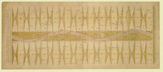
53.
A chart of the zodiacal stars, used in finding the longitude at sea by the moon. And their hourly positions to the circumpolar
stars, both above and below the north and south poles. By S. Dunn. London.
Cartographer:
S. Dunn.
|
4 July 1772. |
Size of paper: 38.1 x 90.1 cm.
Colored.
|
(523.29: 1772 Large) |
|
Provenance:
Presented by Samuel Dunn, 8 October 1772.
|
|
|
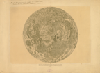
54.
[Map of the moon accompanied by an explanation of the figures and letters]. N.p.: [ca.1832].
Cartographer:
J. J. Littrow and Albert Richard.
|
[ca.1832]. |
Size: 40 cm. diameter.
|
(022: [ca.1832]: L722mar Large) |
|
Enclosed in original wrapper marked: DERMOND.
Provenance:
Presented by C. Nagy, 15 May 1833.
|
|
|
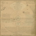
55.
Sketch of the solar system for the use of schools. Printed at the Lith. Press of His Majesty the King of Oude. Lucknow: 1835.
|
1835. |
Size: 75.2 x 73.9 cm.
|
(523.2: Sk2s Large) |
|
Provenance:
Presented by J. P. Engles.
|
|
|
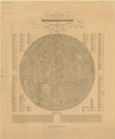
56.
General-Karte der sichtbaren Seite der Mondoberflaeche zugleich als übersichts-Blatt zur grössern Mondkarte von Wilh. Beer
und Joh. Heinr. Mädler. Berlin: Simon Schropp et Comp.: 1837.
Cartographer:
Wilh. Beer and Joh. Heinr. Mädler.
Engraver:
E. Leidenfrost.
|
1837. |
Size of paper: 59 x 48.3 cm.
|
(022: 1837: B397gks Small) |
|
Provenance:
Presented by A. D. Bache, 6 December 1839.
|
|
|
57.
Celestial charts made at the Litchfield Observatory of Hamilton College, Clinton, N.Y., by C. H. F. Peters. N.p.: [ca. 1884].
|
[ca. 1884]. |
20 charts.
Size of paper: 58 x 40 cm.Original wrappers.
|
(525.5: L7lc Large) |
|
58.
Lick Observatory atlas of the moon. N.p.: [ca. 1895].
|
[ca. 1895]. |
20 plates.
Size of paper: 50.3 x 40.5 cm.
|
(022: [ca. 1895]: L627atm Small) |
|
There is also one photograph entitled: Mond-Atlas von L. Weinek.
Provenance:
Provenance: Published by the gift of W.W. Law, from original negatives.
|
|
|
59.
Egyptian chart of the heavens. Constellations of the northern hemisphere. By Lee H. McCoy. Pueblo, Colo.: Franklin Press Co.: 1911 [24 July 1911].
Cartographer:
Lee H. McCoy.
|
24 July 1911. |
Size of paper: 43.2 x 41 cm.
|
(523.89: M13e Small) |
|
McCoy wrote that this chart of the ancient Egyptian constellations contained "but about one half" of the Egyptian constellations
he had worked out and that he would like to hear from the Society about it.
Provenance:
Presented by Lee H. McCoy, 3 August 1911.
|
|
|
60.
Copernican system. N.p.: n.d.
|
n.d. |
Size: 19.2 x 20.3 cm.
|
(521.5: C79s Small) |
|
61.
[Lunar orbiter material. Missions 1-5]. U.S. National Aeronautics and Space Administration. N.d.
|
n.d. |
|
(523.39: Un3L) |