Realms of Gold: A Catalogue of Maps in the Library of the American Philosophical Society
Part II: Printed Maps -
Arctic
(9 items)
|
 |
|
|
|
|
|
|
|
|
|
|
|
|
|
|
|
|
|
The Arctic
|
|
|
|
|
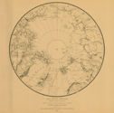
92.
[Circular map of the arctic regions]. N.p.: [ca. 1790].
|
[ca. 1790]. |
Size: 24 cm. diameter.
|
(171: [ca. 1790]: Ar21oce Small) |
|
Endorsed: Late eighteenth-century hand: North Pole.
Contains: Mr. Hearn's "Rout" in 1771 from Fort Churchill.
Published for William Guthrie, Atlas to his system of geography. The Transactions (vol. 6) state that Carey presented the "Materials from which Guthrie's Geography were compiled." This is one of those maps.
See: William Guthrie, The general atlas for Carey's edition of his geography improved. Philadelphia: Carey: 1795 [1 May 1795].
Provenance:
Presented by Mathew Carey, 18 October 1805.
|
|
|
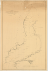
93.
Arctic Sea. Baffin Bay. Sheet 1. 1853. London: Hydrographic Office of the Admiralty. Corrected to 1855. [London]. 1855.
Engraver:
J. & C. Walker.
|
1855. |
Size: 63.3 x 48.5 cm.
|
(171: 1855: Ar27bab Large) |
|
Insets: Omenak Fiord; and Disko Bay.
There are ten engravings of capes, inlets, islands, etc.
|
|
|
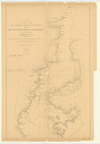
94.
Chart exhibiting the discoveries of the Second American Grinnell Expedition in search of Sir John Franklin. Unrevised from
the original material and projected on the spot. E. K. Kane. Deposited 15 November 1855.
Cartographer:
E. K. Kane.
Engraver:
Julius Bien.
|
15 November 1855. |
Scale: 2.8 cm. = 10 mi.
Size: 89 x 56.2 cm.
|
(172.3: 1855: G895exp Large) |
|
Provenance:
Presented by E. K. Kane.
|
|
|
95.
Arctic Sea. Melville Sound. Sheet II. 1856. [London]: 1856 [26 May 1856].
Engraver:
J. & C. Walker.
|
26 May 1856. |
Size: 63.7 x 49.7 cm.
|
(171: 1856: Ar27mvs Large) |
|
96.
Chart showing the discoveries tracks and surveys of the Arctic Exploring Expedition of 1860 and 1861. I. I. Hayes, M.D., commanding. Newly projected from revised materials discussed for the Smithsonian Institution by Charles A. Schott. Washington: 1865.
Cartographer:
Charles A. Schott.
Engraver:
H. S. Barnard and A. Petersen.
|
1865. |
Scale: 1:1,200,000.
Size: 57.8 x 36.2 cm.
|
(171: 1865: Sch67aee Small) |
|
|
|
|
97.
The Arctic regions comprising the most recent explorations of Robert E. Peary, Fridtjov Nansen, and F. Jackson, by Prof. Angelo
Heilprin. Philadelphia: Geographical Society of Philadelphia: 1897.
Cartographer:
Angelo Heilprin and J. W. Ross.
|
1897. |
Size of page: 45 x 49.5 cm.
|
(170: 1897: H343pnj Small) |
|
|
|
|
98.
Arctic Regions [showing bank ice, cold currents & warm currents]. N.p.: [ca. 1900].
|
[ca. 1900]. |
Size of paper: 26.9 x 23.1 cm.
Colored.
|
(171: [ca. 1900]: Ar21npc Small) |
|
99.
Polar regions Baffin Bay to Lincoln Sea, showing the recent discoveries and routes of exploration of Civil Engineer Robert
E. Peary U.S.N. together with the work of earlier explorers. Based on the chart of the Hydrographic Office. Washington: 1903.
Cartographer:
F. B. Greene.
|
1903. |
Size: 48.2 x 44.2 cm.
Colored.
|
(176: 1903: P316bbL Small) |
|
To accompany Bulletin, vol. IV, no. 1, Geographical Society of Philadelphia.
"The name United States Coast, designating the most northernly land-mass, was suggested by Commander Perry in letter, Feb.
22, 1904."
|
|
|
100.
Physical map of the Arctic. Translated and revised by the American Geographical Society of New York from map in Andrée's Handatlas,
8th edition, 1924. Printed in Germany. Copyright, 1929, by the American Geographical Society of New York. New York: 1929.
|
1924. |
Size of page: 46 x 58.6 cm.
Scale of main map: 1:20,000,000.
Colored.
|
(170: 1924:Am31phy Small) |
|
Insets: Novaya Zemlya, Jan Mayen Island, Bear Island, Ice Fiord (Spitsbergen), Spitsbergen and Bear Island, Franz Josef Land, Eastern
Greenland, Bering Strait, Northernmost Greenland, Southern Greenland, and Smith Sound to Robeson Channel.
|
|