|
|
|
|
|
|
|
|
|
|
|
|
|
|
|
|
|
Canada
|
|
|
|
|
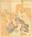
471.
Map of the Dominion of Canada. Geologically colored from surveys made by the Geological Corps, 1842 to 1882. Alfred R. C. Selwyn, director. Geological and
Natural History Survey of Canada. Montreal: Burland: [1882].
Cartographer:
Alfred R. C. Selwyn.
|
[1882]. |
Scale: 1:2,851,200.
Size: 65.2 x 199.8 cm.
Colored.
|
(610: [1882]: C162gns Large) |
|
472.
Map of the Dominion of Canada. Map illustrating water power of Canada. To accompany presidential address. Royal Society, Canada, May 1899. James White, geographer. N.p: 1900. Second ed.
Cartographer:
James White.
|
1900. |
Scale: 1:6,336,000.
Size: 43.5 x 92.9 cm.
Colored.
|
(610: 1900: C162cwp Large) |
|
473.
Relief map of Canada and the United States. George M. Dawson, director. Orographic features of the Dominion of Canada compiled from various sources. Data for the United
States from the map published by the U.S. Geological Survey. Geological Survey of Canada. Toronto: Toronto Lith. Co.: 1900.
Cartographer:
George M. Dawson.
|
1900. |
Scale: 1 in. = 350 mi.
Size: 51 x 44.5 cm.
Colored.
|
(610: 1900: C162srm Large) |
|
474.
Relief map of the Dominion of Canada. James White, geographer. Department of the Interior of Canada. N.p. [1904].
Cartographer:
James White.
|
[1904]. |
Scale: 1:6,336,000.
Size: 43.6 x 92.9 cm.
Colored.
|
(610: [1904]: C162rmd Large) |
|
See: Department of the Interior, Canada, Dictionary of altitudes . . . 1903
|
|
|
475.
Map of the Dominion of Canada. 1908. James White, chief geographer. Department of the Interior of Canada. N.p.: [1908].
Cartographer:
James White.
|
[1908]. |
Scale: 1:6,366,000.
Size: 49.5 x 88.6 cm.
Colored.
|
(610: [1908]: C162mdc Large) |
|
476.
Railway map of the Dominion of Canada. Department of the Interior of Canada. James White, geographer. N.p.: 1909.
Cartographer:
James White.
|
1909. |
8 sheets.
Scale: 1:2,217,600.
Size of each sheet: Ca. 67 x 65 cm.
Colored.
|
(610: 1909: C162dom Extra-oversize) |
|
477.
Railway map of the Dominion of Canada. Department of the Interior of Canada. 1920. J. E. Chalifour, chief geographer. N.p.: [1920].
Cartographer:
J. E. Chalifour.
|
[1920]. |
8 sheets.
Scale: 1:2,217,600.
Size of each sheet: Ca. 78 x 65 cm.
Colored.
|
(610: [1920]: C162dom Extra-oversize) |
|
478.
Canada. J. E. Chalifour, chief geographer. Department of the Interior of Canada. Natural Resources Intelligence Service. N.p.: 1925.
Cartographer:
J. E. Chalifour.
|
1925. |
Scale: 1:3,801,600.
Size: 99.2 x 151.6 cm.
Colored.
|
(610: 1925: C162nrs Large) |
|
Inset: Canada [northern North America].
|
|
|
479.
Map of the Dominion of Canada. Department of the Interior of Canada. Natural Resources Intelligence Service. J. E. Chalifour, chief geographer. 1927. N.p.:
[1927].
Cartographer:
J. E. Chalifour.
|
[1927]. |
Scale: 1:6,336,000.
Size: 49.8 x 89.4 cm.
Colored.
|
(610: [1927]:C162nrs Small) |
|
Contains railroad and steamship routes, with legends.
|
|
|
480.
Dominion of Canada. Department of Mines and Resources of Canada. J. Wardle, director. Ottawa: 1937.
Cartographer:
J. Wardle.
|
1937. |
Scale: 1:6,336,000.
Size: 61 x 87.6 cm.
Colored.
|
(610: 1937: W211dmr Large) |
|
481.
Tectonic map of Canada. Lambert conformal conic projection—standard parallels 47° 30' and 65° 30'. Prepared by the Geological Association of Canada with the support of the Geological Society of America. Washington: Williams
& Heintz, lith.: 1950.
Engraver:
Williams & Heintz.
|
1950. |
Scale: 1:3,801,600.
Size: 101.5 x 145.3 cm.
|
(610: 1950: C162tec Roller) |
|
482.
Canada. Index to maps of the old geographic series. Department of Mines and Resources of Canada. J. M. Wardle, director. N.d.
Cartographer:
J. M. Wardle.
|
n.d. |
Scales: 1:250,000 and 1:500,000.
Size: 22.2 x 46.9 cm.
Colored.
|
(610: n.d.: C162dmr Small) |
|
Inset: British Columbia and Alberta.
Provenance:
Presented by Mrs. A. I. Hallowell, November 1983.
|
|
|
Eastern Canada
|
|
|
|
|
483.
A new correct map of the seat of war in lower Canada protracted from Holland's large map compiled from actual survey made
by order of the provincial government laid down with many late additions and improvements by Amos Lay. Philadelphia: A. Lay & J. Webster: [1814].
Cartographer:
Holland and Amos Lay.
Engraver:
H . S. Tanner.
|
[1814]. |
Scale: 1 in. = 7 mi.
Size: 54.9 x 84.9 cm.
Colored.
|
(612: [1814]: L455swc Large) |
|
484.
A map of the province of Upper Canada and the adjacent territories in North America compiled by James G. Chewitt shewing the
districts, counties and townships in which are situated the lands purchased from the crown by the Canada Company. Incorporated 1825. N.p.: [1825].
Cartographer:
James G. Chewett.
Engraver:
I. S. Cox.
|
[1825]. |
Size: 98.6 x 179.1 cm.
Colored.
|
(612: [1825]: C412puc Large) |
|
485.
Maps to illustrate reports by Loring Woard Bailey, George Frederick Matthew, Robert Walpole Ellis and Albert Peter Low. Geological Survey of Canada. 1882-1883. Montreal: Canada Bank Note Co.: 1884.
Cartographer:
Wallace Broad, William Mclnnes, Robert Wheelock Ells, Albert Peter Low, and N. J. Giroux.
|
1884. |
10 maps.
Scale: 1 in. = 4 mi.
Colored.
|
(610: 1884: C162rep Small) |
|
Province of New Brunswick. 32.1 x 47.7 cm.; Province of Quebec. 32 x 47.4 cm.; Province of Quebec. 32.1 x 47.2 cm.; Part of
New Brunswick and Prince Edward Island. 31.9 x 47.1 cm.; Prince Edward Island. 32 x 47.2 cm.; Prince Edward Island. 16.7 x
47.1 cm.; Province of Quebec. 32 x 47.2 cm.; Province of Quebec. 32 x 47 cm.; Province of Quebec. 32.1 x 47.3 cm.; Province
of Quebec. 32 x 47.3 cm.
|
|
|
486.
The Eskimo tribes of north-east America. By Franz Boas. [New York]: Julius Bien & Co. Lith.: [ca. 1888].
Cartographer:
Franz Boas.
Engraver:
Julius Bien & Co.
|
[ca. 1888]. |
Size: 19⅜ in. x 17 3/16 in.
Colored.
|
(610: [ca. 1888]: B638etr Small) |
|
See: U.S. Bureau of American Ethnology. Franz Boas, "The Central Eskimo."Sixth Annual Report.
Provenance:
Presented by Mrs. Helene Boas Yampolsky, 1961-1962.
|
|
|
487.
[Map showing in detail the geographical divisions of territory occupied by the Eskimo tribes of northeastern America]. By Franz Boas. [New York]: Julius Bien & Co.: [ca. 1888].
Cartographer:
Franz Boas.
Engraver:
Julius Bien & Co.
|
[ca. 1888]. |
Size: 20⅞ in. x 18¾ in.
Colored.
|
(610: [ca. 1888]: B638est Small) |
|
1. Oqo and Akudnirn; 2. Frobisher Bay; 3. Eclipse Sound and Lyon inlet; 4. Repulse Bay and Lyon inlet; 5. Boothia Isthmus
and King William Land.
See: U.S. Bureau of American Ethnology. Franz Boas, "The Central Eskimo." Sixth Annual Report.
Provenance:
Presented by Mrs. Helene Boas Yampolsky, 1961-1962.
|
|
|
488.
Index maps for annual report. Geological Survey of Canada. Part A, vol. XIV. Robert Bell . . . acting director.
Cartographer:
C. O. Senécal and Robert Bell.
|
1901. |
Colored.
|
(610: 1901: C162sLs Small) |
|
1. New Brunswick, Prince Edward Island & part of Quebec. 27 x 40.5 cm.; 2. Nova Scotia. 28.4 x 38.2 cm.; 3. Northwestern Ontario.
17.7 x 30.6 cm.; 4. Southern British Columbia. 22.2 x 40.5 cm.
|
|
|
489.
Geological map of the northeastern part of the Dominion of Canada, to illustrate the report on the cruise of D. G. S. Neptune
to Hudson Bay and the Arctic Islands, by A. P. Low. Geological Survey of Canada. 1905.
Cartographer:
A. P. Low, C. F. King, and P. Frèreault.
|
1905. |
Scale: 1 in. = 50 mi.
Size: 92 x 68.9 cm.
Colored.
|
(610: 1905: L955 Large) |
|
Inset: Fullerton harbor.
Provenance:
Presented by Mrs. A. I. Hallowell, November 1983.
|
|
|
490.
Highways map of eastern Canada and adjacent states. [Toronto]: Imperial Oil Ltd.: 1930.
Cartographer:
A. R. Thomson.
Engraver:
Rolph Clark Stone, Ltd.
|
1930. |
Scale: 1 in. = 40 mi.
Size: 57.3 x 88.8 cm.
Colored.
|
(610.5: 1930: T388eca Large) |
|
Inset: Trans-Canada highway (proposed); Canada; District of Montreal, Quebec; Rideau Lakes, Ontario; Muskoga and Lake of Bays,
Ontario; Kawartha Lakes, Ontario; and 40 smaller places.
Provenance:
Presented by Mrs. A. I. Hallowell, November 1983.
|
|
|
491.
[Turner valley], Geological Survey of Canada. N.p.: [ca. 1939].
|
[ca. 1939]. |
9 maps.
Sizes: Various.
|
(610: [ca. 1939]: T857val Large) |
|
Nova Scotia And New Brunswick, Canada
|
|
|
|
|
492.
A new and accurate map of the Province of Nova Scotia, in North America; from the latest observations. N.p.: [ca. 1758].
|
[ca. 1758]. |
Size: 28.2 x 33.4 cm.
|
(611.5: [ca. 1758]: N856nsa Small) |
|
493.
[Map of Pasamaquody Bay and the St. Croix River, including Deer, Campo Bello and Grand Manan Islands, New Brunswick, Canada]. N.p.: [ca. 1790].
|
[ca. 1790]. |
Scale: 1 in. = ¾ mi.
Size: 150.5 x 119 cm.
|
(611.3: [ca. 1790]: N426bru Large) |
|
494.
A new pocket map of the peninsula of Nova Scotia. Intended as a topographical guide, also to illustrate its geological structure,
according to the observations of Messrs. Jackson & Alger. Compiled from the most recent surveys. 1841.
Cartographer:
Jackson and Alger.
|
1841. |
Scale: 1½cm. = 10 mi.
Size: 23.6 x 42.6 cm.
Colored.
|
(611.5: 1841: J134nov Book map) |
|
495.
New Brunswick and Nova Scotia. Atlas of the world. Maritime provinces, p.77. Rand, McNally & Co.: 1895.
|
1895. |
Scale: 1 in. = 37 mi.
Size: 23.5 x 31.8 cm.
Colored.
|
(611: 1895: N428nns Small) |
|
On same sheet is: Manitoba, Atlas of the world . . . 1895.
Provenance:
Presented by Mrs. A. I. Hallowell, November 1983.
|
|
|
496.
Whiteburn gold district Queens County Nova Scotia. Department of Mines of Canada. Geological Survey. William Mclnnes, directing geologist. Publication No. 1690. Economic geology.
Structural plan. N.p.: 1917.
Cartographer:
C.-O. Senécal, A. S. Jost, and William Mclnnes.
|
1917. |
Scale: 1:4,800.
Size: 50.4 x 62 cm.
Colored.
|
(611.5: 1917: C162wgq Small) |
|
Quebec, Canada
|
|
|
|
|
497.
A plan of Quebec, metropolis of Canada in North America. [1775]
Engraver:
Aitken.
|
[1775]. |
Scale: [2.5 cm. = ca. 300 yds.].
Size: 11 x 17.7 cm.
Colored.
|
(050: P383) |
|
In: Pennsylvania Magazine, vol. 1 (1775), opposite p. 563.
Wheat: 90
|
|
|
498.
Plan of the town & fortifications of Montreal or Ville Marie in Canada. [1775].
Engraver:
Aitkin [sic].
|
[1775]. |
Scale: 2.5 cm. = 90 French toises.
Size: 24.4 x 16.6 cm.
|
(050: P383) |
|
In: (Philadelphia) Pennsylvania Magazine, vol. 1 (1775), opposite p. 517.
Wheat: 91
|
|
|
499.
Map of the inhabited part of Canada, from the French surveys; with the frontiers of New York and New England; from the large
survey by Claude Joseph Sauthier. To Major General John Burgoyne. . . . Wm. Faden. London: W. Faden: 1777.
Cartographer:
Claude Joseph Sauthier.
Engraver:
William Faden.
|
1777. |
Scale: 69½ British statute mi. = 1 degree.
Size: 57.5 x 87.4 cm.
Colored.
|
(612: 1777: S97fsc Large) |
|
See: W. Faden, North American Atlas. London: W. Faden: 1777. No. 4.
Provenance:
From the George Ord purchase, 21 June 1839. Librarian George Ord visited France several times and was authorized
to purchase books for the Library. Occasionally he purchased either manuscripts or maps as well.
|
|
|
500.
Map of Upper Canada, describing all the new settlements, townships, etc. with the countries adjacent, from Quebec to Lake
Huron. Compiled at the request of His Excellency Major General John G. Simcoe. ... By David William Smyth. With additions and corrections from Holland's three sheet map. New York: Prior & Dunning: 1813.
Cartographer:
Sir David William Smyth and Holland.
Engraver:
James D. Stout.
|
1813. |
Size: 54 x 84 cm.
Colored.
|
(612: 1813: Sm97uc Large) |
|
501.
Plan of Quebec and adjacent country showing the principal encampments & works of the British & French armies during the siege
by General Wolfe in 1759. Reduced from the mss. map of Captain J. G. Glegg, by John Melish. The different parts of this map were surveyed as follows.
The east coast of the Falls of Montmorency, the point of Orleans & the south side of the River St. Lawrence, by Capt. Digby,
Engineer in Ordinary. The coasts of Beauport, from the River St. Charles to the Falls of Montmorency, by Capt. Holland, of
the Royal Americans, Assis[tan]t Engineer. The ground between the River St. Lawrence & the River St. Charles, by Lieut. Desbarres,
of the Royal Americans, Assis[tan]t Engineer. Philadelphia: Melish: 1813.
Cartographer:
J. B. Glegg, John Melish, Capt. Digby, Samuel Jan Holland, and J. F. W. Desbarres.
Engraver:
H. S. Tanner.
|
1813. |
Scale: l in. = 1000 yds.
Size: 23.2 x 50.8 cm.
Colored.
Size of paper: 44.8 x 57 cm.
|
(612.966: 1813: M485que Large) |
|
Inset: View of Quebec from Point Levi.
In: John Melish, A military and topographical atlas of the United States; including the British possessions & Florida. Philadelphia: 1813.
|
|
|
502.
Quebec. Montreal and Quebec sheet. Standard topographical map. Department of the Interior of Canada. Sheet 11. 1920.
Cartographer:
J. E. Chalifour, geographer.
|
1920. |
Scale: 1:500,000.
Size: 69.2 x 49.7 cm.
Colored.
|
(612: 1920: C357qmo Large) |
|
Contains manuscript notes and markings pertaining to the Indians.
Provenance:
Presented by Mrs. A. I. Hallowell, November 1983.
|
|
|
503.
Quebec & Ontario. Gatineau Sheet. Department of the Interior of Canada. Standard topographical map. Sheet 10 and part of 33. 1920. Edition
of 1920.
Cartographer:
J. E. Chalifour, chief geographer.
|
1920. |
Scale: 1:500,000.
Size: 77.3 x 50.2 cm.
Colored.
|
(612: 1920: C162qon Large) |
|
Contains manuscript material.
Provenance:
Presented by Mrs. A. I. Hallowell, November 1983.
|
|
|
Ontario, Canada
|
|
|
|
|
504.
Sketch of the navigation through East Neebish rapids River St. Mary from surveys by Captain E. P. Scammon . . . W. H. Hearding,
and C. S. Cole . . . under the direction of Capt. J. N. Macomb, 1853. U.S. War Department. Survey of the lakes. Washington: 1854.
Cartographer:
F. Herbst, E. P. Scammon, W. H. Hearding, C. S. Cole, and J. N. Macomb.
Engraver:
W. H. Dougal.
|
1854. |
Scale: 1:15,000.
Size: 48.1 x 36 cm.
|
(613: 1854: Un38smc Small) |
|
505.
Chart No. 1 of River Ste. Marie from Point Iroquis to East Neebish. Survey of the Northern and North Western lakes. Surveyed under the direction of Captain J. N. Macomb U.S. Army with additions
to date under the orders of Captain G. G. Meade. 1857 [ca. 1858].
Cartographer:
J. N. Macomb, G. G. Meade, and J. U. Mueller.
Engraver:
W. H. Dougal.
|
[ca. 1858]. |
Scale: 8 cm. = 1 mi.
Size: 61 x 80.3 cm.
|
(613: [ca. 1858]: Un38smm Extra-oversize) |
|
Inset: Continuation from Round Id. Point to Point Iroquois.
Provenance:
Presented and endorsed by George G. Meade, 4 April 1861.
|
|
|
506.
Chart no. 2 of River Ste. Marie including the part from the entrance of Mud Lake to the East Neebish. U.S. War Department. Bureau of Topographical Engineers. Survey of the Northern and North Western lakes. Surveyed under the direction of Capt.
J. N. Macomb in 1853 and 1854. Reduction for engraving under the direction of Capt. G. G. Meade, in 1858. [Washington: 1858].
Cartographer:
J. U. Müller, J. N. Macomb, and G. G. Meade.
Engraver:
W. H. Dougal.
|
[1858]. |
Scale: 1:40,000.
Size: 61.8 x 62.3 cm.
|
(613: [1858]: Un38mLn Large) |
|
507.
Mineral district northern Ontario. R. E. Young, chief geographer. Department of the Interior of Canada. N.p.: 1911.
Cartographer:
R. E. Young.
|
1911. |
2 sheets.
Scale: 1:250,000.
Size: 81.4 x 124.3 cm.
Colored.
|
(613: 1911: C162mdo Large) |
|
508.
Map showing branches of chartered banks in Ontario & Quebec. Prepared in the railway lands branch under the direction of F. C. C. Lynch . . . Department of the Interior of Canada. N.p.:
1915. 2nd ed.
Cartographer:
F. C. C. Lynch.
|
1915. |
Scale: 1 in. = 25 mi.
Size: 50.6 x 81.2 cm.
Colored.
|
(612: 1915: C162bcb Small) |
|
Insets: Northern Ontario; Gaspé Peninsula.
With this is a chart showing branches of chartered banks and post office savings banks in Ontario and Quebec.
|
|
|
509.
Mattagami sheet. Ontario. Portions of Algoma, Sudbury and Timiskaming districts. Department of the Interior of Canada. J. E. Chalifour, chief geographer.
Sheet 31. Standard topographical map. N.p.: 1919.
Cartographer:
J. E. Chalifour.
|
1919. |
Scale: 1:500,000.
Size: 69.2 x 47.4 cm.
Colored.
|
(613: 1919: C162oms Small) |
|
510.
Ontario. Department of the Interior of Canada. 1928.
Cartographer:
F. C. C. Lynch and J. E. Chalifour.
|
1928. |
Scale: 1:2,217,600.
Size: 84.6 x 95 cm.
Colored.
|
(613: 1928: C162dic Large) |
|
511.
Ontario. Index to map sheets of the national topographic series. Department of Mines and Resources of Canada. Ottawa: 1943.
|
1943. |
Scale: 1 in. = 1 and 2 mi.
Size: 47.3 x 55.2 cm.
Colored.
|
(613: 1943: C162dmr Large) |
|
On same sheet as: Ontario, Index to map sheets . . . 1943.
Provenance:
Presented by Mrs. A. I. Hallowell, November 1983.
|
|
|
512.
Ontario. Index to map sheets of the national topographic series. Department of Mines and Resources of Canada. Ottawa: 1943.
|
1943. |
Scale: 1 in. = 4 and 8 mi.
Size: 47.3 x 55.2 cm.
Colored.
|
(613: 1943: C162dmr2 Large) |
|
Contains manuscript notations.
On same sheet is: Ontario. Index to map sheets . . . 1943.
Provenance:
Presented by Mrs. A. I. Hallowell, November 1983.
|
|
|
513.
Ontario. Index to map sheets of the national topographic series. Department of the Interior of Canada. Topographical Survey of Canada.
N.d.
|
n.d. |
Scale: 1 in. = 50 mi.
Size: 52.1 x 44.1 cm.
Colored.
|
(613: n.d.: C162ims Large) |
|
Inset: Eastern Ontario.
On reverse is map of Canada. Contains manuscript notations on the American Indian.
Provenance:
Presented by Mrs. A. I. Hallowell, November 1983.
|
|
|
514.
Ontario. Sheet No. 52 N. Department of the Interior of Canada. Topographical Survey of Canada. N.p.: n.d.
|
n.d. |
Size: 45.9 x 56.2 cm.
Colored.
|
(613: n.d.: C162tos Small) |
|
Contains manuscript notations. Trimmed and incomplete.
Provenance:
Presented by Mrs. A. I. Hallowell, November 1983.
|
|
|
Manitoba, Canada
|
|
|
|
|
515.
Manitoba, Atlas of the world. P. 78. Rand McNally & Co.: 1895.
|
1895. |
Scale: 1 in.= 24 mi.
Size: 24 x 32.3 cm.
Colored.
|
(614.1: 1895: M315ppr Small) |
|
On same sheet as: New Brunswick and Nova Scotia, Atlas of the world . . . 1895.
Provenance:
Presented by Mrs. A. I. Hallowell, November 1983.
|
|
|
516.
Railways in Manitoba, Assiniboia, Alberta and Saskatchewan. 1904. James White, geographer. Department of the Interior of Canada. N.p.: [1904].
Cartographer:
James White.
|
[1904]. |
Scale: 1:2,217,600.
Size: 40.2 x 81.6 cm.
Colored.
|
(610.3: [1904]: C162maa Large) |
|
517.
Index showing the townships in Manitoba, Saskatchewan, Alberta and British Columbia. Plans of which have been printed up to the 1st July 1908. Department of the Interior of Canada. Topographical Survey Branch.
Ottawa: [1908].
|
[1908]. |
Scale: 1:2,217,600.
Size: 49.7 x 77.4 cm.
Colored.
|
(614: [1908]: C162msa Large) |
|
Inset: S.W. British Columbia.
|
|
|
518.
Map of Manitoba, Saskatchewan and Alberta. James White, geographer. Department of the Interior of Canada. N.p.: 1909.
Cartographer:
James White.
|
1909. |
4 sheets.
Scale: 1:792,000.
Size: 96.2 x 225.7 cm.
Colored.
|
(610.3: 1909: C162ska Large) |
|
519.
Map showing elevators in Manitoba, Saskatchewan and Alberta. James White, chief geographer. Department of the Interior of Canada. N.p.: [1909]. Edition of April 20th. 1909.
Cartographer:
James White.
|
[1909]. |
Scale: 1 in. = 25 mi.
Size: 40.7 x 87.3 cm.
Colored.
|
(610.3: [1909]: C162sec Large) |
|
Capacity of elevators in Canada printed on the borders.
|
|
|
520.
Grand Rapids, Manitoba. (Provisional edition.) Sheet no. 63-G. Department of the Interior of Canada. Topographical Survey of Canada. Ottawa: 1927.
|
1927. |
Scale: 1:253,440.
Size of paper: 59.9 x 76.1 cm.
Colored.
|
(614.1: 1927: C162grm Large) |
|
Inset: Key map; declination of the compass needle, July 1927.
Provenance:
Presented by Mrs. A. I. Hallowell, November 1983.
|
|
|
521.
Map of Manitoba. Department of the Interior of Canada. N.p.: 1929.
Cartographer:
J. E. Chalifour.
|
1929. |
2 sheets.
Scale: 1:792,000.
Size of each: 74 x 86.4 cm.
Colored.
|
(614.1: 1929: C162dic Large) |
|
522.
Norway House, Manitoba. (Provisional edition.) Sheet No. 63 H. Department of the Interior of Canada. Topographical Survey of Canada. Ottawa: [1929].
|
[1929]. |
Scale: 1:253,440.
Size of paper: 60.8 x 76 cm.
Colored.
|
(614.1: [1929]: C162nhm Large) |
|
Inset: Index map of Manitoba; and the declination of the compass needle, January 1929.
Provenance:
Presented by Mrs. A. I. Hallowell, November 1983.
|
|
|
523.
Oxford House, Manitoba. Department of the Interior of Canada. Topographical Survey of Canada. Sheet No. 53-I. Ottawa: 1929.
|
1929. |
Scale: 1:253,440.
Size of paper: 60.8 x 75.8 cm.
Colored.
|
(614.1: 1929: C162man Large) |
|
Inset: Areas not mapped shaded green; index map for Manitoba; the declination of the compass needle, July 1929.
Provenance:
Presented by Mrs. A. I. Hallowell, November 1983.
|
|
|
524.
Selkirk, Manitoba. Sheet No. 62 I. Department of the Interior of Canada. Topographical Survey of Canada. Ottawa: [1930].
|
[1930]. |
Scale: 1:253,440.
Size of paper: 61 x 76.3 cm.
Colored.
|
(614.1:[1930]: C162sLk Large) |
|
Inset: Index map of Manitoba; the declination of the compass needle, January 1930.
Provenance:
Presented by Mrs. A. I. Hallowell, November 1983.
|
|
|
525.
[Lake Winnipeg and territory to the east]. N.p.: n.d.
|
n.d. |
Size of paper: 89.5 x 121 cm.
Colored.
|
(614.1: n.d.: W731etr Large) |
|
Consists of four maps pasted together. Contains manuscript notes pertaining to the American Indian.
Provenance:
Presented by Mrs. A. I. Hallowell, November 1983.
|
|
|
526.
Manitoba. Southern sheet. Canada. Compiled and engraved at the Chief Geographer's Office. N.p.: n.d.
|
n.d. |
Scale: 1:792,000.
Size: 71 x 86.6 cm.
Colored.
|
(614.1: n.d.: C162cgo Large) |
|
Manuscript markings and notes on the Indian.
Provenance:
Presented by Mrs. A. I. Hallowell, November 1983.
|
|
|
Saskatchewan, Canada
|
|
|
|
|
527.
Saskatchewan and Manitoba. Index to map sheets of the national topographic series. Department of the Interior of Canada. Ottawa: 1928.
|
1928. |
Scale: 1 in. = 50 mi.
Size: 44 x 52.3 cm.
Colored.
|
(614: 1928: C162skm Large) |
|
Contains manuscript notations. On the reverse is a map of Canada.
Provenance:
Presented by Mrs. A. I. Hallowell, November 1983.
|
|
|
528.
Saskatchewan and Manitoba. Index to map sheets of the national topographic series. Department of the Interior of Canada. Topographical Survey of Canada.
Ottawa: 1928.
|
1928. |
Scale: 1 in. = 50 mi.
Size: 43.9 x 52.3 cm.
Colored.
|
(614: 1928: C162skm2 Large) |
|
Contains manuscript notes.
Provenance:
Presented by Mrs. A. I. Hallowell, November 1983.
|
|
|
529.
Saskatchewan. Department of the Interior of Canada. N.p.: 1929.
Cartographer:
J. E. Chalifour.
|
1929. |
2 sheets.
Scale: 1:792,000.
Size of each: 81 x 83.5 cm.
Colored.
|
(614.4: 1929: C162skw Large) |
|
Contains manuscript notations pertaining to the American Indian.
Provenance:
Presented by Mrs. A. I. Hallowell, November 1983.
|
|
|
530.
Saskatchewan. Department of the Interior of Canada. James White, geographer. N.p.: n.d.
Cartographer:
James White.
|
n.d. |
Size: ca. 106.5 x 55.5 cm.
Colored.
|
(614.4: n.d.: W582sas Extra-oversize) |
|
Alberta, Canada
|
|
|
|
|
531.
Map shewing the country between the lower portions of the Peace and Athabasca Rivers north of Lesser Slave Lake. Geological Survey of Canada. George M. Dawson, director. Nos. 1-3. N.p.: 1897.
Cartographer:
C. O. Senécal, G. M. Dawson and R. G. McConnell.
Engraver:
H. B. Baine.
|
1897. |
Scale: 1 in. = 10 statute mi.
Sizes: 42.1 x 64.8 cm.; 66.5 x 42 cm.; 42.1 x 64.8 cm.
Colored.
|
(614.7: 1897: C162dpa Small) |
|
532.
Topographical map of the Rocky Mountains. Banff sheet. Department of the Interior of Canada. James White, geographer. N.p.: 1902.
Cartographer:
James White and W. J. Graham.
|
1902. |
Size: 34.7 x 47.4 cm.
Colored.
|
(614.7: 1902: C162rmb Small) |
|
533.
Topographical map of the Rocky Mountains. Lake Louise sheet. Department of the Interior of Canada. James White, geographer. N.p.: 1902.
Cartographer:
James White.
|
1902. |
Size: 43.5 x 50.4 cm.
Colored.
|
(614.7: 1902: C162rmL Large) |
|
534.
Northern Alberta. Peace River district. James White, geographer. Department of the Interior of Canada. N.p: 1908. Preliminary edition.
Cartographer:
James White.
|
1908. |
Scale: 1:800,000.
Size: 94.9 x 70.3 cm.
Colored.
|
(614.7: 1908: C162prd Large) |
|
535.
Province of Alberta. Department of the Interior of Canada. N.p.: 1930.
Cartographer:
J. E. Chalifour.
|
1930. |
2 sheets.
Scale: 1:792,000.
Size of each: ca. 82 x 89.9 cm.
Colored.
|
(614.7: 1930: C162aLb Large) |
|
Contains manuscript notations.
Provenance:
Presented by Mrs. A. I. Hallowell, November 1983.
|
|
|
536.
Map of Alberta. Department of the Interior of Canada. James White, chief geographer. N.p.: n.d.
Cartographer:
James White.
|
n.d. |
2 sheets.
Size: 83.5 x 91 cm.
Colored.
|
(614.7: n.d.: W582aLb Extra-oversize) |
|
Inset: Peace River block.
|
|
|
British Columbia, Canada
|
|
|
|
|
537.
Maps of the principal auriferous creeks of the Cariboo mining district. Surveyed and drawn by Amos Bowman assisted by James McEvoy. Department of the Interior of Canada. Geological and Natural
History Survey. 1885-1886. N.p.: Mortimer & Co.: [1886].
Cartographer:
Amos Bowman and James McEvoy.
Engraver:
Mortimer & Co.
|
[1886]. |
9 sheets.
Colored.
|
(615:[1886]: C162min Large) |
|
1. Williams Creek, 82.1 x 57.5 cm.; 2. Lightning Creek, 56.6 x 71.4 cm.; 3. Little Snowshoe and Keithley Creeks, 69.2 x 32.5
cm.; 4. Sugar Creek, Hardscrabble, Slough Creek, Nelson Creek, Willow River and Dragon Creek, 67.3 x 43.2 cm.; 5. Cunningham
Creek, 58.4 x 32.cm., 6. Antler Creek, 59.5 x 41.7 cm.; Grouse Creek, 38.4 x 28.7 cm.; 8. Harvey Creek, 30.2 x 22.1 cm.; 9.
Section along Harvey Creek, Size of paper: 34.4 x 52.3 cm.
To illustrate the report of Amos Bowman. See: Note to accompany maps . . . by George M. Dawson, April 1895. Geological and Natural History survey of Canada. Annual report. 1886. Part R.
|
|
|
538.
Map of a portion of the southern interior of British Columbia embodying the explorations made in 1877 by G. M. Dawson & in
1882-1884 by Amos Bowman. Department of the Interior of Canada. Geological and Natural History Survey. Montreal: Burland Lith. Co.: 1888. Preliminary
edition not geol. colored, Dec. 1887.
Cartographer:
G. M. Dawson, Amos Bowman, and Israel Marion.
|
1888. |
Scale: 1:506,880.
Size: 59.7 x 51.9 cm.
|
(615: 1888: C162gnh Large) |
|
539.
Map of Yukon district with the adjacent northern part of British Columbia. 1903. James White, geographer. Department of the Interior of Canada. N.p.: 1903.
Cartographer:
James White.
|
1903. |
Scale: 1:750,000.
Size: 100.2 x 70.9 cm.
Colored.
|
(615.8: 1903: C162ydc Large) |
|
540.
British Columbia railway belt. Department of the Interior of Canada. 1904. James White, geographer. [Ottawa: 1904].
Cartographer:
James White.
|
1904. |
Scale: 1:500,000.
Size: 66.5 x 103.5 cm.
Colored.
|
(615: 1904: C162bcr Large) |
|
541.
British Columbia railway belt. James White, geographer. Special edition prepared under the direction of R. E. Young. Corrected to February 1st 1908. Preliminary
edition. Department of the Interior of Canada. [Ottawa]: 1908.
Cartographer:
James White and R. E. Young.
|
1908. |
2 sheets.
Scale: 1:500,000.
Size: 66.2 x 136 cm.
Colored.
|
(615: 1908: C162bcr Large) |
|
Inset: Vancouver Island.
|
|
|
542.
Topographical sheet. Special map of Rossland British Columbia by W. H. Boyd. Surveyed 1905-1906. No. 1001. Department of Mines of Canada. Geological
Survey Branch. N.p.: 1908.
Cartographer:
W. H. Boyd, A. Dickison, and C.-O. Senécal.
|
1908. |
Scale: 1:4,800.
Size: 44 x 52.5 cm.
Colored.
|
(615: 1908: C162ros Large) |
|
543.
British Columbia & Alberta. Calgary sheet. Standard topographical map. Department of the Interior of Canada. Natural Resources Intelligence Service.
Sheet 20. N.p.: 1925.
Cartographer:
J. E. Chalifour.
|
1925. |
Scale: 1 in. = 7.89 mi.
Size: 69 x 46 cm.
Colored.
|
(615: 1925:C162bcc Small) |
|
544.
British Columbia & Alberta Jasper sheet. Standard topographical map. Sheet 45. Department of the Interior of Canada. Natural Resources Intelligence Service. J. E.
Chalifour, chief geographer. N.p.: 1926.
Cartographer:
J. E. Chalifour.
|
1926. |
Scale: 1 in. = 7.89 mi.
Size: 68.8 x 44.5 cm.
Colored.
|
(615: 1926: C162bca Small) |
|
Northern Canada
|
|
|
|
|
545.
Map showing the townships surveyed in the province of Manitoba and North-West Territory in the Dominion of Canada. Department of the Interior of Canada. Dominion Lands Branch. Published by order of ... David Laird . . . 1874. J. Johnston,
chief draughtsman. New York: H. H. Lloyd & Co.: 1874.
Cartographer:
J. Johnston.
Engraver:
H. H. Lloyd.
|
1874. |
Scale: 1 in. = 6 mi.
Size: 64.3 x 95.5 cm.
|
(617:1874: C162man Large) |
|
546.
Explorations in northern Canada and adjacent portions of Greenland and Alaska. 1904. James White, chief geographer. Department of the Interior of Canada. [Ottawa: 1904].
Cartographer:
James White.
|
[1904]. |
Size: 64.5 x 90.6 cm.
Colored.
|
(610.2: [1904]: C162cga Large) |
|
547.
Yukon Territory Kluane, White, and Alsek Rivers from surveys by International Boundary Commission 1893-1895, J. J. McArthur,
1900, A. D. Talbot, 1899, and J. B. Tyrrell, 1898. Department of the Interior of Canada. James White, geographer. N.p.: 1905.
Cartographer:
James White, J. J. McArthur, A. D. Talbot, and J. B. Tyrrell.
|
1905. |
Scale: 1:400,000.
Size: 88.7 x 57.8 cm.
Colored.
|
(615.8: 1905: C162kwa Large) |
|
548.
Map of part of southwestern coast of Hudson Bay from York factory to Fort Severn. Geological Survey of Canada. From micrometer & compass survey by Owen O'Sullivan. 1905. No. 915. Robert Bell, acting director.
N.p.: 1906.
Cartographer:
P. Frèreault, Owen O'Sullivan, and Robert Bell.
|
1906. |
Scale: 1 in. = 16 mi.
Size: 19.1 x 36.4 cm.
Colored.
|
(617.6: 1906: C162hby Small) |
|
See: Geological Survey of Canada, Summary report. 1905.
|
|
|
549.
Rocky Mountains between lat. 51° and 53° 10'. R. E. Young, chief geographer. Department of the Interior of Canada. N.p.: [1910].
Cartographer:
R. E. Young.
|
[1910]. |
2 sheets.
Scale: 1:253,440.
Size: 99 x 87.1 cm.
Colored.
|
(610.3: [1910]: C162rmL Large) |