|
|
|
|
|
|
|
|
|
|
|
|
|
|
|
|
|
South America
|
|
|
|
|
1553.
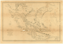
Pilot chart of the Central American waters. January 1915. Prepared from data furnished by the Hydrographic Office of the Navy Department and by the Weather Bureau of
the Department of Agriculture. N.p.: 1915.
|
1915. |
Size: 59.5 x 89.3 cm.
Colored.
|
(701.2: 1915: P643caw Large) |
|
Inset: Gulf of Mexico and Caribbean Sea, with surrounding areas.
|
|
|
1553a.
Mappa geográfico de America Meridional, dispueto y Gravado por D. Juan de la Cruz Cano y Olmedilla. 1775.
Cartographer:
Juan de la Cruz Cano y Olmedilla.
Engraver:
Juan de la Cruz Cano y Olmedilla and Ricarte.
|
1775. |
Scale: 17½ Spanish leagues = 1 degree.
Size: 184 x 130.5 cm.
|
(740: 1775: C882sam Large) |
|
1554.
A map of South America according to the best authorities. London: C. Dilly & G. Robinson: 1785 [1 January 1785].
|
1785. |
Scale: 69 British statute mi. = 1 degree.
Size: 34.2 x 37 cm.
Colored.
|
(740: 1785: D582gga Small) |
|
The Transactions (vol. 6) state that Carey presented the "Materials from which Guthrie's Geography were compiled." This is one of those maps.
See: William Guthrie, The general atlas for Carey's edition of his geography improved. Philadelphia: Carey: 1795 [1 May 1795].
Engraved for William Guthrie, Atlas to his system of geography . . . London: Dilly: 1785.
Provenance:
Presented by Mathew Carey, 18 October 1805.
|
|
|
1555.
A map of South America according to the best authorities. N.p.: [ca. 1790].
|
[ca. 1790]. |
Scale: 69 British statue mi. = 1 degree.
Size: 33.6 x 36.2 cm.
|
(740: [ca. 1790]: So87ces Small) |
|
The Transactions (vol. 6) state that Carey presented the "Materials from which Guthrie's Geography were compiled." This is one of those maps.
See: William Guthrie, The general atlas for Carey's edition of his geography improved. Philadelphia: Carey: 1795 [1 May 1795].
Engraved for Chambers's edition of Guthrie's New system of geography.
Provenance:
Presented by Mathew Carey, 18 October 1805.
|
|
|
1556.
South America from the best authorities. [1790].
Engraver:
Scot.
|
[1790]. |
Size: 17.8 x 21.4 cm.
|
(032: En2) |
|
In: Thomas Dobson, publisher, Encyclopaedia, vol. 1, following p. 538, after the map of North America.
Wheat: 701
Provenance:
Presented by Thomas Dobson, 1798.
|
|
|
1557.
South America. Thomas & Andrews: [ca. 1793].
Engraver:
A. Doolittle.
|
[ca. 1793]. |
Size: 16.1 x 20.7 cm.
|
(740: [ca. 1793]: D722sua Small) |
|
Engraved for Morse's American geography. [The American universal geography]. I, opposite p. 642.
Wheat: 706
|
|
|
1558.
A map of South America and the adjacent islands. 1797.
Engraver:
Callender.
|
1797. |
Size: 16.1 x 11.2 cm.
|
(917.3: M83am) |
|
In:Jedidiah Morse, The American gazettee, opposite "America."
Wheat: 714
|
|
|
1559.
South America from the best surveys. 1799.
Engraver:
Scoles.
|
1799. |
Size: 18.6 x 21.8 cm.
|
(910: P29) |
|
In: John Payne, A new and complete system of universal geography, vol. 4, opposite p. 461.
Wheat: 719
|
|
|
1560.
Carte encyprotype, de l'Amérique Méridionale, dressée par H. Brué. Paris: Desray: 1815.
Cartographer:
Adrien Hubert Brué.
|
1815. |
Scale: 69½ mi. = 1 degree.
Size: 109.5 x 134 cm.
Colored.
|
(740: 1815: B831cam Large) |
|
Inset: Chile, Argentina, and the Falkland Islands [the southern part of the continent].
See: Adrien Hubert Brué, Atlas universel. Paris: Desray: 1816.
|
|
|
1561.
South America from original documents, including the survey by the officers of H.M. Ships Adventure and Beagle. Dedicated
to Captain R. Fitz Roy, R.N. by John Arrowsmith. London: John Arrowsmith: 1839.
|
1839. |
Scale: 69 British mi. = 1 degree.
Size: ca. 61 x 50 cm.
|
(700: 1839: So88abe Small) |
|
Insets: Galapagos Islands; Port San Carlos; Falkland Islands; Southern tip of South America.
Removed from Narrative of the surveying voyages of His Majesty's ships Adventure and Beagle . . . London: 1839.
|
|
|
1562.
[Maps of South America, Central America, West Indies and Mexico] compiled and drawn by the American Geographical Society of
New York. Baltimore: A. Hoen: 1927-1935.
|
1927-1935. |
10 maps.
Scales: 1:1,000,000; 1:400,000.
Sizes: 46 x 60 cm.; 46 x 71 cm.
|
(700: 1927-1935: Am31his Large) |
|
Contents: 1. Atacama, Chile; 2. Panama; 3. Barranquilla, Colombia; 4. Santo Domingo-San Juan; 5. Para, Brazil; 6. Cuyaba,
Brazil; 7. Paranapanema, Brazil; 8. Chihuahua, Mexico; 9. Tierra del Fuego; 10. Cordoba-Santa Fe, Argentina.
|
|
|
Central South America
|
|
|
|
|
1563.
[Track surveys of the tributaries of the Rio la Plata]. By Commander Thomas J. Page, U.S.S. Water Witch 1855. Washington: 1855.
Cartographer:
Thomas J. Page.
Engraver:
G. Stern and J. Bien.
|
[1855]. |
19 maps.
Scale: 1:100,000; 1:2,000,000.
Sizes: ca. 95.6 x 67.5 cm.; and no. 19: 100.5 x 31.5 cm.
|
(744: [1855]: Un36tLp Large) |
|
Contents: 1. Track survey of the River Uruguay with portions of the Rios Negros and Gualeguaychu. Sheet no. 1; 2. ... Sheet
no. 2. Laguna and Sausal Islands to Salto Grande; 3. Track survey of the Rivers Salado, Parana and Colastiné; 4. Mouths of
the Parana and Uruguay. Sheet no. 1. Martin Garcia and Martin Chico Channels; 5. Track survey of the River Parana. Sheet no.
2. (Buenos Aires to Paloma Island); 6. ... Sheet no. 3. (Paloma Island to Curumbé Island); 7. ... Sheet no. 4. (Curumbe Island
to Arroyo Soldado); 8. ... Sheet no. 5. (Arroya Soldado to Acollardo Island); 9. ... Sheet no. 6. (Acollardo Island to mouth
of Colastiné); 10. ... Sheet no. 7. (Mouth of Colastiné to lat. 29° 40"); 11. ... Sheet no. 8. (Lat. 29° 55" to lat. 28° 40");
12. ... Sheet no. 9. (Lat. 28° 40" to Guardia Cerrito); 13. Track survey of the River Paraguay. Sheet no. 10. (From Guardia
Cerrito to lat. 26° 5" near Oliva); 14. . . . Sheet no. 11. (Oliva to Rio
Praguaymy); 15. . . . Sheet no. 12. (Rio Paraguaymy to Concepcion); 16. ... Sheet no. 13. (From Concepcion to Lat.
21° 40"); 17. ... Sheet no. 14. (From Lat. 21° 40" to 20° 10"); 18. ... Sheet no. 15. (From Lat. 20° 10" to Curumba); 19.
Reference chart to the track survey of the tributaries of Rio la Plata.
Provenance:
Presented by T. J. Page on 16 October and 18 December 1857, and on 2 April and 15-16 October 1858.
|
|
|
1564.
Map of the basin of La Plata, based upon the results of the expedition under the command of Thomas J. Page, U.S. Navy, in
the years 1853, '54, '55 & 56. And of the adjacent countries. Compiled from the best authorities. U.S. Navy Department. [New York: 1856].
Cartographer:
Thomas J. Page.
Engraver:
J. Bien.
|
[1856]. |
Scale: 1:3,000,000.
Size: 90.8 x 65.6 cm.
Colored.
|
(744: [1856]: Un36bLp Book map) |
|
See: Track surveys . . . map no. 1563.
Provenance:
Presented by Thomas J. Page, 17 September 1858.
|
|
|
Colombia
|
|
|
|
|
1565.
Island of old Providence. N.p.: [ca. 1771]
Engraver:
Prinald.
|
[ca. 1771]. |
Size: 17.7 x 14.5 cm.
|
(752.74: [ca. 1771]: P936iop Small) |
|
See: Joseph Smith Speer, West-India pilot. London: Hooper: 1771.
|
|
|
1566.
Plan of Carthagena Harbour and city in lattd. 0/10:26. to 0/10:15 north. London: S. Hooper: 1771 [1 October 1771].
Engraver:
Bayly.
|
1771. |
Size: 47.3 x 34.1 cm.
|
(752.923: 1771: B341chc Small) |
|
See: Joseph Smith Speer, West-India pilot. London: Hooper: 1771.
|
|
|
1567.
[Plan of the city and suburbs of Carthagena]. N.p.: [ca. 1771].
Engraver:
J. Gibson.
|
[ca. 1771]. |
Scale: 9 in. = 400 toises.
Size: 25 x 32.8 cm.
|
(752.923: [ca. 1771]: G353pcs Small) |
|
Along left side is list of references for the plan of the city.
See: Joseph Smith Speer, West-India pilot. London: Hooper: 1771.
|
|
|
1568.
Interoceanic ship canal via the Atrato and Truando rivers. N.p.: [ca. 1860-1861?]
|
[ca. 1860-1861?]. |
Size: 56 x 114 cm.
|
(752: [ca. 1860-1861?]: In83cat Small) |
|
To accompany U.S. 36th Congress. 2nd Session Senate Executive Documents, No. 9.
|
|
|
Venezuela
|
|
|
|
|
1569.
Geologic-tectonic map of the United States of Venezuela (except the territory of Amazonas and part of the state of Bolivar),
compiled by Walter H. Bucher, Columbia University. Published by the Geological Society of America. Washington: Williams & Heintz Co.: 1950.
Cartographer:
Walter H. Bucher.
|
1950. |
Scale: 1 in. = 25 mi.
Size: 81.5 x 147 cm.
|
(753: 1950: V558geo Roller) |
|
See: W. H. Bucher, Geologic structure and orogenic history of Venezuela. [New York]: Geological Society of America: 1952.
|
|
|
Peru
|
|
|
|
|
1570.
[Collection of maps of the rivers, cities, etc., of Peru]. Sociedad Geográfica de Lima, Peru. Lima: 1861-1913.
Cartographer:
Fitz-Carrald.
|
1861-1913. |
31 maps.
Scale: Various.
Size: Various.
Colored.
|
(764.2: 1861-1913: P436geo Large) |
|
Contents: 1. Mapa popular del Peru; 2-3. Mapa del departamento de Loreto; 4. Plano del rio Ucayali; .5. Vias de comunicacion
entre Paita, Eten y parte navegable del rio Alto Marañon; 6. Mapa del Alto Yurua y Alto Purus; 7. Mapa de la provincia de
Pacasmayo; 8. Plano del Rio Tigre; 9. Plano del Rio Napo; 10. Plano del Rios Pachitea y Pichis; 11. Lago Titicaca . . .; 12.
. . . los Rios Tigre, Pastaza y Morona; 13. Mapa que comprende las ultimas exploraciones y estudios verificados desde 1900
hasta 1906; 14. Plano del Rio Putumayo; 15. Plano del Rio Bajo Marañon; 16. Plano del Rio Serjali; 17. Plano del Cuzco; 18.
Plano del Rio Huallago; 19. Plano del Rio Tambopata; 20. Mapa histórico geográfico de los valles de Paucartambo; 21. Plano
del Rio Pastaza. 22. Plano del Rio Manú. 23. . . . Casma á Chacas; 24. Region oriental del Peru; 25. Plano del Rio "Ucayali"
. . .; 26. Geologia de los inmediaciones de Morococha; 27. Croquis de los Rios Napo y Putumayo; 28. . . .
Navegacion del Alto Marañon; 29. Plano del Rio Amazonas Peruano; 30. Croquis de los rios Alto Ucayali y Bajo Urubamba;
31. Croquis general de los rios estudiados por la comision exploradora del Istmo Fitz-Carrald.
|
|
|
Bolivia
|
|
|
|
|
1571.
Mappa de la República de Bolivia mandado organizar y publicar por el Presidente Constitutional, General José Manuel Pando. Formado por Eduardo Idiaquez. Reprinted by the International Bureau of the American Republics. Washington: Graham: 1901.
Cartographer:
Eduardo Idiaquez and Victor Puig.
Engraver:
Erhard Hermanos, Paris.
|
1901. |
Scale: 1:2,000,000.
Size: 104.6 x 89.8 cm.
Colored.
|
(766: 1901: Id14mrb Large) |
|
Brazil
|
|
|
|
|
1572.
Folhas topographicas. Commissão Geographica e Geologica de S. Paulo. São Paulo: 1905-1911.
|
1905-1911. |
9 sheets.
Scale: 1:100,000.
Size: Various.
Colored.
|
(774.8: 1905-1911: Sa67top Large) |
|
Contents: 1. Folha de Bragança. Preliminary edition, 1909; 2. Folha de Casa Branca. Preliminary edition, 1905; 3. Folha de
S. Bento. Preliminary edition, 1909; 4. Folha de Pindamonhangaba. Preliminary edition, 1905; 5. Folha de Pirassununga. Preliminary
edition, 1905; 6. Folha de São Paulo. Preliminary edition, 1905; 7. Folha de Franca. Preliminary edition, 1911; 8. Folha de
S. Sebastião do Paraizo. Preliminary edition, 1911; 9. Folha de Mococa. Preliminary edition, 1911.
|
|
|
1573.
Carta general do Estado de S. Paulo. Organisada pela Commissão Geographica e Geologica. São Paulo: 1908.
|
1908. |
Scale: 1:1,000,000.
Size: 66.2 x 106.2 cm.; 1910 map, 33 x 52.4 cm.
Colored.
|
(774.8: 1912: Sa67geo Large) |
|
Inset:Planta da Ciudade de S. Paulo.
Contains also editions of 1910 and 1912.
|
|
|
1574.
Geological sketch map of the region about Natal, Rio Grande do Norte, Brazil. By Olaf P. Jenkins. N.p.: [ca. 1913].
Cartographer:
Olaf P. Jenkins.
|
[ca. 1913]. |
Scale: 2.5 cm = 2 mi.
Size: 49.2 x 48.5 cm.
|
(770: [ca. 1913]: J425nat Large) |
|
Inset: Index map.
|
|
|
Chile
|
|
|
|
|
1575.
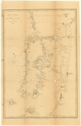
The Strait of Magalhaens, commonly called Magellan. Surveyed by the officers of His Majesty's Ships, Adventure and Beagle. Under the direction of Captains Phillip Parker King,
F.R.S., Pringle Stokes & Robert Fitz Roy. 1826-34. London: Henry Colburn: 1839.
Cartographer:
Phillip Parker King, Pringle Stokes, and Robert Fitz Roy.
Engraver:
J. Gardner.
|
1839. |
Size: 31.4 x 46.9 cm.
|
(782.669: 1839: K588abe Small) |
|
Removed from Narrative of the surveying voyages of His Majesty's ships Adventure and Beagle. . . London: 1839.
|
|
|
1576.
Part of Tierra del Fuego from H.M.S. Beagle. 1834. London: Henry Colburn: 1839.
Engraver:
J. & C. Walker.
|
1839. |
Size: 31.4 x 47.1 cm.
|
(782: 1839: P255bea Small) |
|
Removed from Narrative of the surveying voyages of His Majesty's ships Adventure and Beagle . . . London: 1839.
|
|
|
1577.
Chiloe and parts of the adjacent coasts from H.M.S. Beagle. 1835. London: Henry Colburn: 1839.
Engraver:
J. & C. Walker.
|
1839. |
Size: 46.6 x 31.8 cm.
|
(782: 1839: C435bea Small) |
|
Removed from Narrative of the surveying voyages of His Majesty's ships Adventure and Beagle . . . London: 1839.
|
|
|
Argentina
|
|
|
|
|
1578.
Southern portion of South America. Henry Colburn: 1839.
Engraver:
J. Dower.
|
1839. |
Scale: 1 in. = 180 geographic mi.
Size: 33.1 x 35.6 cm.
|
(780: 1839: So88sop Small) |
|
Removed from Narrative of the surveying voyages of His Majesty's ships Adventure and Beagle . . . London: 1839.
|
|
|
1579.
Mapa de los ferrocarriles de la republica Argentina. Ministerio de Obras Publicas. N.p.: 1900.
|
1900. |
Size: 25.5 x 18.8 cm.
Colored.
|
(784: 1900: Ar41rra Small) |
|
1580.
Maps of the Argentine Republic. N.p.: 1909.
|
1909. |
4 maps.
Scale: 1:8,500,000.
Size: 46.4 x 29 cm.; the hyposometric card is 26.9 x 21.1 cm.
Colored.
|
(744: 1909: Ar11rep Small) |
|
Contents: map of the Argentine Republic; map of the meteorological stations; map of the hydrometrical stations: hypsometric
card.
|
|