|
|
|
|
|
|
|
|
|
|
|
|
|
|
|
|
|
New England
|
|
|
|
|
634.
Charts of the coast and harbours of New England . . . from the surveys taken by Samuel Holland. [London]: 1776.
Cartographer:
Samuel Holland and J. F. W. Des Barres.
|
1776. |
7 pieces.
Scale: Various.
Size: Various.
|
(640.1: 1776: D452cne Large) |
|
See: Samuel Holland. Atlas . . . London: 1776.
|
|
|
635.
[Southern shore of New England from New York City to Barnstable, with map of Long Island. This is one section of a large topographical map intended to cover the entire United States and possibly more.] [1794. 1961
reprint].
Engraver:
Eliza Colles.
|
[1794]. |
Scale: 2.5 cm. = 10 mi.
Size: 14.2 x 9.8 cm.
|
(526.8: C68s) |
|
In: Christopher Colles, A survey of the roads, p. 80.
Wheat: 155
|
|
|
636.
The New England commercial and route survey, showing good auto roads, good roads, steep decline, electric railways, state
capitals, state boundaries, court house, etc. Boston: The Bullard Co.: 1916.
|
1916. |
Scale: 1 in. = 9 mi.
Size of paper: 110.8 x 116.2 cm.
|
(640.1: 1916: N423crs Large) |
|
Insets: Boston and vicinity; and Bar Harbour and vicinity.
On same sheet as: A map of Cape Cod and its approaches . . .1916.
Provenance:
Presented by Mrs. A. I. Hallowell, November 1983.
|
|
|
Maine
|
|
|
|
|
637.
Maine. [1795].
|
[1795]. |
Scale: 2.5 cm. = 44 mi.
Size: 18.7 x 15.5 cm.
|
(Paine 68: Sco3u) |
|
In: Joseph Scott, The United States gazetteer, opposite "Maine."
Wheat: 173
Provenance:
Presented by the Estate of Richard Gimbel, 1974.
|
|
|
638.
A map of the district of Maine drawn from the latest surveys and other best authorities. 1795.
Cartographer:
Osgood Carleton.
Engraver:
Doolittle.
|
1795. |
Scale: 2.5 cm. = 18 English statute mi.
Size: 50 x 40.7 cm.
|
(974.1: Su5) |
|
Inset: A map of those parts of the country most famous for being harassed by the Indians.
In: James Sullivan, The history of the district of Maine, frontispiece.
Wheat: 171
Provenance:
Presented by Jeremy Belknap, 15 October 1784.
|
|
|
639.
Province of Maine. [1796].
Engraver:
Amos Doolittle.
|
[1796]. |
Scale: 2.5 cm. = 50 mi.
Size: 19 x 14.5 cm.
|
(917.3: C25c) |
|
In: Mathew Carey, Carey's American pocket atlas, opposite p. 22.
Wheat: 174
Provenance:
Presented by Suzanne Wister Eastwick and Joseph L. Eastwick, July 1975.
|
|
|
640.
The province of Maine from the best authorities. 1799.
|
1799. |
Scale: 2.5 cm. = 35 mi.
Size: 26.8 x 18.5 cm.
|
(910: P29) |
|
In: John Payne, A new and complete system of universal geography, vol. 4, opposite p. 253.
Wheat: 178
|
|
|
641.
Map of the district of Maine from the latest and best authorities. By Moses Greenleaf Esqr. 1815. Boston: Cummings & Hilliard: 1815 [30 October 1815].
Cartographer:
Moses Greenleaf.
Engraver:
W. B. Annin.
|
30 October 1815. |
Scale: 1:506,880.
Size: 103.3 x 66.8 cm.
Colored.
|
(641: 1815: G843mdm Large) |
|
See: Moses Greenleaf, Statistical view of the district of Maine. Boston: Cummings: 1816.
Provenance:
Provennace: Presented by Robert M. Gardner, 19 June 1818.
|
|
|
642.
Richmond's island harbor, [Maine] (Harbor of refuge No. [blank]) from a trigonometrical survey under the direction of A. D.
Bache. U.S. Coast and Geodetic Survey. [Washington]: 1851.
Cartographer:
A. D. Bache, J. Lambert, and John R. Barker.
Engraver:
S. Siebert, J. V. N. Throop, and W. Smith.
|
1851. |
Scale: 1:20,000.
Size: 35.6 x 43.7 cm.
|
(641: 1851: Un38rih Small) |
|
643.
York River Harbor, Maine. U.S. Coast Survey. A. D. Bache, Supdt. [Washington]: 1854.
Cartographer:
F. Fairfax, A. D. Bache, T. D. Cram, and A. W. Longfellow.
Engraver:
A. Maedel, J. Young, and C. A. Knight.
|
1854. |
Scale: 1:20,000.
Size: 31.7 x 40.1 cm.
|
(641: 1854: Un38yrh Small) |
|
644.
Eastport harbor, Maine . . . U.S. Coast Survey. This chart is based upon a survey made under the direction of A. D. Bache. [Washington]: 1876.
Cartographer:
A. D. Bache, C. O. Boutelle, W. H. Dennis, S. A. Gilbert and W. H. Richardson.
|
1876. |
Scale: 1:40,000.
Size: 65.9 x 45.7 cm.
|
(641: 1876: Un38ehm Large) |
|
Spencer C. McCorkle wrote 14 December that many U.S. Coast and Geodetic Survey charts were seldom issued since "bouys &c.
on the bars & in the rivers & harbors, are constantly changing (at least some of them) & were corrected every year or so"
[Archives. U.S. Coast and Geodetic Survey to H. Phillips, 14 December 1885]. However, on 21 December he sent 29 charts. These
were "all that can be spared at present." As soon as a new edition of the charts for the Delaware River in front of Philadelphia
was issued, the Society would receive a copy. He enclosed a listing of the charts he sent: 302A Eastport Harbor Me. 103 Mt.
Desert Id. 104 Penobscot Bay. 325 Portland harbor. 337 Boston harbor. 353 Narragansett Bay. 359a Harbor of New London & Thames
R. 369 New York bay and harbor. 121 Sandy Hook to Barnegat Lt Hs. 122 Barnegat Lt Hs to Absecon Lt. 377 Cape May city & vicinity
topl map. 379 Delaware breakwater. 126b Delaware River Cherry Id Flats to Bridenberg. 126c Delaware River Bombay Hook Lt to
Cherry Id. 131 Entrance to Chesapeake Bay. 384 Patapsca River & Baltimore harbor. 391a Washington & Georgetown harbor. 404b
Norfolk harbor. 431 Charleston harbor. 156 Savannah to Sapelo Id. 455a Jacksonville to Hibernia Fla. 469 Key West harbor.
177 Tampa Bay. 188 Mobile Bay. 510 No. 8 New Orleans to Sonias' Plantation. 30 Galveston bay Texas. 621 San Francisco entrance
Cal. 617 Monterey harbor. 652 Pugets Sound Washington Terry [Archives. U.S. Coast. . . Survey List; 1885].
Provenance:
Presented by the U.S. Coast and Geodetic Survey, 14 December 1885.
|
|
|
645.
Coast chart no. 3. Mount Desert Island, Frenchman's and Blue Hill bays and approaches. Maine. U.S. Coast and Geodetic Survey. [Washington: 1885].
Cartographer:
A. D. Bache, A. Lindenkohl, C.Junken, and H. Lindenkohl.
Engraver:
J. Enthoffer, E. A. Maedel, J. G. Thompson. F. Courtenay, and H. M. Knight.
|
[1885]. |
Scale: 1:80,000.
Size: 96.1 x 74 cm.
|
(641: [1885]: Un38fbh Large) |
|
646.
Coast chart no. 4. Penobscot bay, Maine. U.S. Coast and Geodetic Survey. [Washington]: 1885.
Cartographer:
A. D. Bache.
|
1885. |
Scale: 1:80,000.
Size: 96 x 74.5 cm.
|
(641: 1885: Un38pbm Large) |
|
647.
Portland harbor, Maine. From a trigonometrical survey under the direction of A. D. Bache. 1871. U.S. Coast Survey. [Washington: 1885].
Cartographer:
A. D. Bache, A. W. Longfellow, C. O. Boutelle, P. Witzel, and A. Balbach.
Engraver:
G. B. Metzroth and A. Petersen.
|
[1885]. |
Scale: 1:20,000.
Size: 72.6 x 64.5 cm.
|
(641: [1885]: Un38phm Large) |
|
648.
Maine. [From: Atlas of the world, p. 9]. Rand, McNally & Co.: 1898.
|
1898. |
Scale: 1 in. = 26 mi.
Size: 32 x 23.5 cm.
Colored.
|
(641: 1898: M288nap Small) |
|
On same sheet is: New Hampshire, Atlas of the world. 1898.
Provenance:
Presented by Mrs. A. I. Hallowell, November 1983.
|
|
|
649.
Map of Mount Desert Island, Maine. Compiled by Waldron Bates, Edward L. Rand and Herbert Jacques, 1896, and revised 1901. Boston: Geo. H. Walker: 1901.
Cartographer:
W. Bates, E. L. Rand, H.Jacques, and William H. Munroe.
|
1901. |
Scale: 1:40,000.
Size: 76.5 x 61.5 cm.
Colored.
|
(641: 1901:B311mdi Large) |
|
Nomenclature revised and corrected—adapted from the map dated June 1893, compiled for the Flora of Mt. Desert Island. For text see: Edward L. Rand and John Howard Redfield, Flora of Mt. Desert Island, Maine. Cambridge: Wilson: 1894.
|
|
|
650.
Railroad map of Maine. Prepared under the direction of, and presented by Elmer P. Spofford, Frank Keizer, and John A. James. New York: George F.
Cram: 1913 [30 June 1913].
Cartographer:
E. P. Spofford, Frank Keizer, and John A. James.
Engraver:
George F. Cram.
|
30 June 1913. |
Scale: 1 in. = 8 mi.
Size: 103 x 79 cm.
Colored.
|
(641: 1913: M285rrc Book map) |
|
Inset: Vicinity of Portland.
|
|
|
New Hampshire
|
|
|
|
|
651.
An accurate map of New Hampshire in New England, from a late survey. [London: R. Sayer and T. Jeffery: 1768].
|
[1768]. |
Size: 32.5 x 27.7 cm.
|
(642: [1768]: Sa97nh Small) |
|
Original in T. Jefferys, General topography of North America and the West Indies. London: R. Sayer and T. Jefferys: 1768.
|
|
|
652.
A topographical map of the state of New Hampshire, surveyed under the direction of Samuel Holland Esqr Surveyor General of
lands for the northern district of North America. London: William Faden: 1784 [1 March 1784].
Cartographer:
Samuel Holland.
|
[1 March 1784]. |
Scale: 1¾ in. = 12 mi.
Size: 53.1 x 35.7 cm.
|
(642: 1784: H723tnh Small) |
|
Facsimile.
Wheat: 180
|
|
|
653.
A new map of New Hampshire. 1791.
Cartographer:
Jeremy Belknap.
Engraver:
S. Hill.
|
1791. |
Scale: 2.5 cm. = 12 mi.
Size: 38.3 x 25.7 cm.
|
(641: 1791: B411nh Small) |
|
See: Jeremy Belknap, History of New Hampshire, vol. 2, frontispiece.
Wheat: 183
Provenance:
Presented by Jeremy Belknap, 1784-1792.
|
|
|
654.
Newhampshire. [1795].
|
[1795]. |
Scale: 2.5 cm. = 24 mi.
Size: 18.9 x 15.5 cm.
|
(Paine 68: Sco3u) |
|
In: Joseph Scott, The United States gazetteer, opposite "New-Hampshire."
Wheat: 186
Provenance:
Presented by the Estate of Richard Gimbel, 1974.
|
|
|
655.
The state of New Hampshire. [1796].
Cartographer:
Samuel Lewis.
Engraver:
Seymour.
|
[1796]. |
Scale: 2.5 cm. = 26 American mi.
Size: 19 x 14.6 cm.
|
(917.3: C25c) |
|
In: Mathew Carey, Carey's American pocket atlas, opposite p. 18.
Wheat: 187
Provenance:
Presented by Suzanne Wister Eastwick and Joseph L. Eastwick, July 1975.
|
|
|
656.
The state of New Hampshire compiled chiefly from actual surveys. 1799.
Cartographer:
A. Anderson.
Engraver:
C. Tiebout.
|
1799. |
Scale: 2.5 cm. = 17 mi.
Size: 29.5 x 18.5 cm.
|
(910: P29) |
|
In: John Payne, A new and complete system of universal geography, vol. 4, opposite p. 229.
Wheat: 190
|
|
|
657.
Map of New Hampshire by Philip Carrigain. 1816. [Concord: 1816].
Cartographer:
Philip Carrigain.
|
1816. |
Size: 70.4 x 41.7 cm.
|
(642: 1816: C232mnh Large) |
|
Inset: View of the White Mountains from Shelburne; the cap of the White Mountains.
|
|
|
658.
Map of New Hampshire & Vermont: published by Thomas, Cowperthwait & Co. [Philadelphia]: Thomas, Cowperthwait & Co.: 1850.
|
1850. |
Scale: 1 in. = 15 mi.
Size: 38 x 30.8 cm.
Colored.
|
(642: 1850: C832nhv Small) |
|
659.
Atlas accompanying the report on the geology of New Hampshire. C. H. Hitchcock, state geologist. Geological Survey of New Hampshire. 1878. New York: J. Bien: 1878.
Cartographer:
C. H. Hitchcock.
Engraver:
Julius Bien.
|
1878. |
15 sheets.
Scale: 1 in. = 2½ mi.
Size: 54 x 65 cm.
Colored.
|
(642: 1878: N466geo Extra-oversize) |
|
See: New Hampshire, Geological Survey, Report. . .
Provenance:
Presented by the state of New Hampshire, 4 October 1878.
|
|
|
660.
New Hampshire. [From: Atlas of the world, p. 10]. Rand, McNally & Co.: 1898.
|
1898. |
Scale: 1 in. = 15.5 mi.
Size: 32 x 23.5 cm.
Colored.
|
(642: 1898: N428nap Small) |
|
On same sheet as: Maine, Atlas of the world. 1898.
Provenance:
Presented by Mrs. A. I. Hallowell, November 1983.
|
|
|
Vermont
|
|
|
|
|
661.
A map of the state of Vermont. 1793.
Cartographer:
J. Whitelaw.
Engraver:
Callendar.
|
1793. |
Scale: 2.5 cm. = 12½ mi.
Size: 35.7 x 25.8 cm.
|
(974.3: W67) |
|
In: Samuel Williams, The natural and civil history of Vermont, frontispiece.
Wheat: 194
|
|
|
662.
State of Vermont. [1795].
|
[1795]. |
Scale: 2.5 cm. = 2.2 mi.
Size: 19.1 x 15.9 cm.
|
(Paine 68: Sco3u) |
|
In: Joseph Scott, The United States gazetteer, opposite "Vermont."
Wheat: 196
Provenance:
Presented by the Estate of Richard Gimbel, 1974.
|
|
|
663.
A correct map of the state of Vermont from actual survey; exhibiting the country and town lines, rivers, lakes, ponds, mountains,
meetinghouses, mills, public roads &c. By James Whitelaw, 1796. New Haven: A. Doolittle: 1796.
Cartographer:
James Whitelaw.
Engraver:
Amos Doolittle.
|
1796. |
Scale: 1:253,440.
Size: 114.5 x 76.8 cm.
Colored.
|
(643: 1796: W589msv Large) |
|
Wheat: 200
|
|
|
664.
Vermont, from actual survey. [1796].
Engraver:
Seymour.
|
[1796]. |
Scale: 2.5 cm. = 24 American mi.
Size: 19.3 x 14.6 cm.
|
(917.3: C25c) |
|
In: Mathew Carey, Carey's American pocket atlas, opposite p. 12.
Wheat: 197
Provenance:
Presented by Suzanne Wister Eastwick and Joseph L. Eastwick, July 1975.
|
|
|
665.
Vermont from the latest authorities. [1799].
Cartographer:
Alexander Anderson.
Engraver:
Cornelius Tiebout.
|
[1799]. |
Scale: 2.5 cm. = 18 mi.
Size: 23 x 18.7 cm.
|
(910: P29) |
|
In: John Payne, A new and complete system of universal geography, vol. 4, opposite p. 229.
Wheat: 201
|
|
|
666.
Geographical, statistical, and historical map of Vermont. N.p.: [1830].
Cartographer:
F. Lucas, Jr.
Engraver:
Young and Delleker.
|
[1830]. |
Scale: 1 in. = 15 mi.
Size: 31 x 24 cm.
Size of paper: 44.5 x 54.9 cm.
Colored.
|
(643: [1830]: L965ver Small) |
|
On three sides are data concerning Vermont. Franklin is a place name.
|
|
|
667.
Vermont. [From: Atlas of the world, p. 11]. Rand, McNally & Co.: 1898.
|
1898. |
Scale: 1 in. = 14 mi.
Size: 31 x 24 cm.
Colored.
|
(642: 1898: V598mas Small) |
|
On same sheet is: Massachusetts, Atlas of the world, 1898.
Provenance:
Presented by Mrs. A. I. Hallowell, November 1983.
|
|
|
668.
State of Vermont. U.S. Geological Survey. George Otis Smith, director. Compiled in 1910-1911. [Washington]: 1910-1911.
Cartographer:
R. B. Marshall, A. F. Hassan, and George Otis Smith.
|
1910-1911. |
Scale: 1:500,000.
Size: 53.5 x 32.2 cm.
|
(643: 1910-1911: Un38int Small) |
|
International map of the world. U.S. section.
|
|
|
Massachusetts
|
|
|
|
|
669.
A new and accurate map of the present seat of war in North America, from a late survey. [London: 1775].
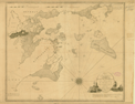
Cartographer:
Thomas Kitchin (?).
|
[1775]. |
Scale: 69½ English statute mi. = 1 degree.
Size: 28.8 x 37.8 cm.
Colored.
|
(640.1: [1775]: K644wna Small) |
|
"For the London Magazine." London: 1775.
|
|
|
670.
Map of the island of Nantucket. [London: Davies: 1782].
Cartographer:
James Tupper.
|
[1782]. |
Size: 19.5 x 24.7 cm.
|
(644: [1782]: T838nm Small) |
|
Original in M. G. J. de Crèvecoeur, Letters from an American farmer. London: Davies: 1782.
|
|
|
671.
A map of the county of Worcester. [1793].
Cartographer:
Charles Baker and John Peirce.
Engraver:
Seymour.
|
[1793]. |
Scale: 2.5 cm. = 4 mi.
Size: 36 x 31.3 cm.
|
(974.4: W61) |
|
In: Peter Whitney, The history of the county of Worcester, frontispiece.
Wheat: 211
Provenance:
Presented by John Vaughan, 20 December 1839.
|
|
|
672.
Massachusetts. [1795].
|
[1795]. |
Scale: 2.5 cm. = 30 mi.
Size: 15.3 x 18.3 cm.
|
(Paine 68: Sco3u) |
|
In: Joseph Scott, The United States gazetteer, opposite "Massachusetts."
Wheat: 216
Provenance:
Presented by the Estate of Richard Gimbel, 1974.
|
|
|
673.
Massachusetts. [1796].
Engraver:
W. Barker.
|
[1796]. |
Scale: 2.5 cm. = 27 mi.
Size: 14.9 x 19.2 cm.
|
(917.3: C25c) |
|
In: Mathew Carey, Carey's American pocket atlas, opposite p. 26.
Wheat: 217
Provenance:
Presented by Suzanne Wister Eastwick and Joseph L. Eastwick, July 1975.
|
|
|
674.
The state of Massachusetts from the best authorities. 1799.
Cartographer:
A. Anderson.
Engraver:
C. Tiebout.
|
1799. |
Scale: 2.5 cm. = 20 American mi.
Size: 19 x 23.5 cm.
|
(910:P29) |
|
In: John Payne, A new and complete system of universal geography, vol. 4, opposite p. 235.
Wheat: 222
|
|
|
675.
Chart of the harbors of Salem, Marblehead, Beverly and Manchester. From a survey taken in the years 1804, 5 & 6 by Nath[anie]l Bowditch . . . assisted by Geo. Burchmore & Wm. Ropes 3rd. N.p.:
1806 [27 June 1806].
Cartographer:
Nathaniel Bowditch, George Burchmore, and William Ropes III.
Engraver:
Hooker & Fairman.
|
[27 June 1806]. |
Scale: 2 in. = 1¼ statute mi.
Size: 54.1 x 65.2 cm.
|
(644: 1806: B672smb Large) |
|
Provenance:
Presented and endorsed by Nathaniel Bowditch, 20 October 1809.
|
|
|
676.
Map of the American coast, from Lynhaven Bay to Narragansett Bay, by John Melish. Philadelphia: Melish: 1813.
Cartographer:
John Melish.
Engraver:
H. S. Tanner.
|
1813. |
Scale: 1 in. = 20 mi.
Size: 40.3 x 46.3 cm.
Colored.
|
(635: 1813: M485ac Small) |
|
Originally in: John Melish, Military and topographical atlas. Philadelphia: Palmer: 1813.
|
|
|
677.
Survey across the Isthmus of Cape Cod state of Massachusetts and town of Sandwich of a proposed canal between Buzzard's and
Barnstable bays. 1825. Surveyed by the U.S. Army Corps of Topographical Engineers under the direction of Major Per[r]ault. [Washington]: 1825.
Cartographer:
Major Perrault, Frederick Searle, W. B. Thompson, and John Farley.
|
1825. |
3 sheets.
Scale: 1 in. = 880 yd.
|
(644: 1825: Un31bb Small) |
|
No. 1. Survey across isthmus. 26.4 x 47.4 cm. No. 2. Profile of proposed route. 27.5 x 46.7 cm. No. 3. Survey of a valley
& ponds. 20.8 x 35.8 cm.
Provenance:
Presented by General Daniel Parker, 1 January 1833.
|
|
|
678.
Plan of a survey for the proposed Boston and Providence rail-way. By James Hayward. Jan. 1828. [Boston]: 1828.
Cartographer:
James Hayward.
Engraver:
Annin and Smith.
|
1828. |
Scale: 1 in. = 1 mi.
Size: 18.8 x 108 cm.
|
(640.1: 1828: H333bpr Small) |
|
Map made to accompany report of the commissioners.
|
|
|
679.
A map of the extremity of Cape Cod including the townships of Provincetown & Truro: with a chart of their sea coast and of
Cape Cod harbor . . . Executed under the direction of J. D. Graham . . . during . . . years 1833, '34, & '35. U.S. Army. Corps of Topographical Engineers. Reduced from original . . . by Wash: Hood: 1836. [Washington]: 1836.
Cartographer:
J. E. Johnston, A. A. Humphreys, J. N. Macomb, W. R. Palmer, and J. D. Graham.
Engraver:
W. J. Stone.
|
1836. |
Scale: 1:10,560.
Size: 148 x 178.3 cm.
|
(644: 1836: Un38ccp Large) |
|
See: U.S. Congress. 25th Congress. 2nd Session.Report. . . .
Provenance:
Presented by James Duncan Graham, 19 July 1844; one copy was presented by Graham, 20 December 1839.
|
|
|
680.
A map of the town of Taunton, with a view of the public buildings. Published by Saml. O. Dunbar. Taunton: S. O. Dunbar: 1836.
Cartographer:
Samuel O. Dunbar.
Engraver:
Pendleton.
|
1836. |
Scale: 1 in. = 170 rods.
Size: 77.8 x 56.7 cm.
|
(644.981: 1836: D912tpb Large) |
|
Inset: Map of the village of Taunton.
There are engravings of 13 public buildings on the map.
Provenance:
Presented by the Reverend E. Neville, 5 April 1839.
|
|
|
681.
Map of the Island of Nantucket, including Tuckernuck. Surveyed by William Mitchell. 1838. Boston: E. W. Bouvé: 1838.
Cartographer:
William Mitchell and E. W. Bouvé.
Engraver:
E. W. Bouvé.
|
1838. |
Scale: 1:47,520.
Size: 60.2 x 85.7 cm.
|
(644: 1838: M695ntm Large) |
|
682.
Chart of Cape Cod harbor and the adjacent coast of Provincetown and Truro. Reduced from the original of Major James D. Graham . . . U.S. Army. Corps of Topographical Engineers. Published under the
patronage of the Boston Marine Insurance Company by I. W. P. Lewis. [Washington]: 1841.
Cartographer:
James D. Graham and I. W. P. Lewis.
Engraver:
W.J. Stone.
|
1841. |
Scale: 1:21,120.
Size: 71.2 x 85.1 cm.
|
(644: 1841: Un38cch Large) |
|
683.
Cape Cod harbour and adjacent coast, reduced from the survey of Major J. D. Graham, U.S. Topographical Engineers. U.S. Army. 1833, 34 & 35. [Washington: ca. 1842].
Cartographer:
J. D. Graham.
Engraver:
Hooker and Harrison.
|
[ca. 1842]. |
Scale: 1 in. = 1 mi.
Size: 22.3 x 30.9 cm.
|
(644: [ca. 1842]: Un31cch Small) |
|
684.
Harbor of New Bedford founded upon a trigonometrical survey under the direction of A. D. Bache. U.S. Coast and Geodetic Survey. [Washington]: 1846.
Cartographer:
A. D. Bache, C. M. Eakin, H. L. Whiting, and G. S. Blake.
Engraver:
Sherman & Smith.
|
1846. |
Scale: 1:40,000.
Size: 44.7 x 35.8 cm.
|
(644: 1846: Un38hnb Small) |
|
685.
The harbor of Holmes' Hole; [and] the harbor of Tarpaulin Cove founded upon a trigonometrical survey under the direction of
A. D. Bache. U.S. Coast and Geodetic Survey. [Washington]: 1847. 2 maps on one sheet.
Cartographer:
A. D. Bache, C. M. Eakin, W. M. Boyce, G. S. Blake, and M. I. McClery.
Engraver:
Sherman and Smith.
|
1847. |
Scale: 1:20,000.
Size: 43.9 x 35.9 cm.
|
(644: 1847: Un33hhtc Small) |
|
Both maps marked "Harbor of Refuge No. [blank]."
|
|
|
686.
Edgartown harbor founded upon a trigonometrical survey under the direction of A. D. Bache. U.S. Coast and Geodetic Survey. [Washington]: 1848.
Cartographer:
A. D. Bache, C. M. Eakin, H. L. Whiting, C. H. Davis, M. I. McClery, and John Robertson.
|
1848. |
Scale: 1:20,000.
Size: 43.7 x 35.9 cm.
|
(644: 1848: Un33eh Small) |
|
687.
Nantucket harbor from a trigonometrical survey under the direction of A. D. Bache. U.S. Coast and Geodetic Survey. [Washington]: 1848.
Cartographer:
A. D. Bache, C. M. Eakin, H. L. Whiting, C. H. Davis, J. M. Wampler, and J. Robertson.
Engraver:
F. Dankworth, O. A. Lawson, J. H. Young, J. Knight, and W. Smith.
|
1848. |
Scale: 1:20,000.
Size: 35.8 x 44 cm.
|
(644: 1848: Un33nh Small) |
|
688.
The harbor of Hyannis from a trigonometrical survey under the direction of A. D. Bache. U.S. Coast and Geodetic Survey. [Washington]: 1850.
Cartographer:
A. D. Bache, C. M. Eakin, W. M. Boyce, J. N. Maffitt, and Wm. Luce.
Engraver:
Sherman and Smith.
|
1850. |
Scale: 1:30,000.
Size: 46.9 x 35.8 cm.
|
(644: 1850: Un33hh Small) |
|
689.
Plano del puerto de Holmes' Hole levantado por el teniente de la Armada de los Estados-Unidos G. S. Blake en 1847. Madrid: 1851.
Cartographer:
G. S. Blake and F. Bregante.
|
1851. |
Scale: 3¼ in. = 1 sea mi.
Size: 20.9 x 32.6 cm.
|
(644: 1851: B581hh Small) |
|
690.
Wellfleet harbor Massachusetts from a trigonometrical survey under the direction of A. D. Bache. U.S. Coast and Geodetic Survey. [Washington]: 1853.
Cartographer:
A. D. Bache, T. J. Cram, H. L. Whiting, J. B. Glück, C. H. McBlair, W M. C. Fairfax, J. J. Ricketts, and M. C. Gritzner.
Engraver:
S. Siebert, E. F. Woodward, and S. E. Stull.
|
1853. |
Scale: 1:50,000.
Size: 35.6 x 44.3 cm.
|
(644: 1853: Un33wh Small) |
|
691.
Gloucester harbor Massachusetts from a trigonometrical survey under the direction of A. D. Bache. U.S. Coast and Geodetic Survey. [Washington]: 1855.
Cartographer:
A. D. Bache, C. O. Boutelle, H. L. Whiting, H. S. Stellwagen, L. Daser, and W. T. Martin.
Engraver:
G. B. Metzeroth and J. L. Hazzard.
|
1855. |
Scale: 1:20,000.
Size: 44.7 x 35.1 cm.
|
(644: 1855: Un33gh Small) |
|
692.
Newburyport harbor, Massachusetts. From a trigonometrical survey under the direction of A. D. Bache. U.S. Coast and Geodetic Survey. [Washington]: 1855.
Cartographer:
C. O. Boutelle, A. D. Bache, A. W. Longfellow, M. Woodhull, and C. Mahon.
Engraver:
S. Siebert, A. Rollé, W. Smith, E. Yeager, J. Young, and H. C. Evens.
|
1855. |
Scale: 1:20,000.
Size: 42.5 x 62.4 cm.
|
(644: 1855: Un38nph Large) |
|
693.
Salem harbor, Massachusetts. From a trigonometrical survey under the direction of A. D. Bache. U.S. Coast and Geodetic Survey. [Washington]: 1855.
Cartographer:
A. D. Bache, C. O. Boutelle, H. L. Whiting, C. H. McBlair, C. Mahon, and C. Farquahar.
Engraver:
F. Danksworth, H. M. Knight, J. Knight, S. E. Stull, and J. Young.
|
1855. |
Scale: 1:25,000.
Size: 52.7 x 70.3 cm.
|
(644: 1855: Un38shm Large) |
|
Provenance:
Presented by the U.S. Treasury Department through A. D. Bache, 6 March 1857.
|
|
|
694.
Massachusetts. [From: Atlas of the world , p. 12]. Rand, McNally & Co.: 1898.
|
1898. |
Scale: 1 in. = 15.5 mi.
Size: 23 x 31.6 cm.
Colored.
|
(644: 1898: M385ver Small) |
|
On same sheet as: Vermont, Atlas of the world. 1898.
Provenance:
Presented by Mrs. A. I. Hallowell, November 1983.
|
|
|
695.
A map of Cape Cod and its approaches, showing through roads, good roads, local roads, private roads, churches, schools, cemeteries,
town halls, light houses, post office, altitudes (173), gradual decline, steep decline . . . Boston: The Bullard Co.: 1916.
|
1916. |
Size of paper: 110.8 x 116.2 cm.
Colored.
|
(644: 1916: M386ccb Large) |
|
Insets: Maps of Boston and vicinity; Nantucket; Martha's Vineyard.
On reverse is: The New England commercial and route survey. 1916.
Provenance:
Presented by Mrs. A. I. Hallowell, November 1983.
|
|
|
696.
A prospect of Harvard University and Radcliffe College, Cambridge, Massachusetts. Boston: Merrymount Press: 1935.
Cartographer:
Edwin J. Schruers.
|
1935. |
Scale: 1 in. = 200 ft.
Size: 82.2 x 61.4 cm.
Colored.
|
(644: 1935: H266sch Extra-Oversize) |
|
Boston
|
|
|
|
|
697.
A new and correct plan of the town of Boston, and provincial camp. [1775].
Engraver:
Aitken.
|
[1775]. |
Scale: [2.5 cm. = ¼ mi.].
Size: 26 x 18.9 cm.
|
(050: P383) |
|
Inset: [Map of the country around Boston].
In: Pennsylvania Magazine, vol. 1 (1775), opposite p. 291.
Wheat: 238
|
|
|
698.
A new plan of Boston harbour from an actual survey. [1775].
Engraver:
Clownes [Caleb Lownes].
|
[1775]. |
Scale: [2.5 cm. = 1 ¾ mi.].
Size: 25.5 x 18.9 cm.
|
(050: P383) |
|
In: Pennsylvania Magazine, vol. 1 (1775), opposite p. 241.
Wheat: 239
|
|
|
699.
Plan of Boston in New England with its environs, including Milton, Dorchester, Roxbury, Brookline, Cambridge, Medford, Charlestown,
parts of Malden and Chelsea. With the military works constructed in those places in the years 1775 and 1776. [Signed] : Henry Pelham. London: 1777 [2
June 1777].
Cartographer:
Henry Pelham.
Engraver:
Francis Jukes.
|
[2 June 1777]. |
Scale: 1:50,000.
Size: 99.3 x 69.3 cm.
|
(644.917: 1777: P366bne Large) |
|
Provenance:
Presented by Edward Hudson, 5 January 1827.
|
|
|
700.
A map of the seat of the late war at Boston in the state of Massachusetts. [1789].
Engraver:
[James Trenchard?].
|
[1789]. |
Size: 17.2 x 25.5 cm.
|
(050: C72) |
|
In: Columbia Magazine, vol. 3, opposite p. [385].
Wheat: 208
|
|
|
701.
[A plan of the town and chart of the harbor of Boston.] N.p.: [ca. 1795].
|
[ca. 1795]. |
Size: 26.1 x 34 cm.
|
(644.917: [ca. 1795]: B651pth Large) |
|
702.
Sketch of the action on the heights of Charles Town 17 June 1775, between his majesty's troops under the command of M. Genl.
Howe and a large body of American rebels. Philadelphia: Harrison Hall: 1818.
Cartographer:
Henry de Berniére and H. Dearborn.
|
1818. |
Size: 33.3 x 50.2 cm.
|
(644: 1775: D325chm.a Small) |
|
On map: "N.B. the parts in red are corrections of the original by Maj. Gen. Dearborn." However, on this printed map there
are no red lines.
|
|
|
703.
Map of Boston and its vicinity. From actual survey by John G. Hales. Boston: Hales. Philadelphia: Melish: 1819.
Cartographer:
John G. Hales.
Engraver:
Edwin Gillingham.
|
1819. |
Scale: 1:63,360.
Size: 65.2 x 80.7 cm.
Colored.
|
(644.917: 1819: H133bav Large) |
|
704.
Plan of Mount Auburn, by Alex[ande]r L. Wadsworth. November 1831. Boston: Pendleton: 1831.
Cartographer:
A. L. Wadsworth.
Engraver:
Pendleton.
|
1831. |
Scale: 1 in. = 7½ rods.
Size: 55.1 x 44.6 cm.
Colored.
|
(644.917: 1831: W193pma Large) |
|
Autograph note at bottom: "It is supposed that 3 to 4000 lots may be laid out without removing the trees & shrubbery so as
to mar the beauty of the spot."
See: Joseph Story, Address delivered on the dedication of the cemetery. Boston: Buckingham: 1831; and James Mease, Gingerbread age. New York: Rinehart: 1957.
|
|
|
705.
Boston harbor, Massachusetts. From a trigonometrical survey under the direction of A. D. Bache. U.S. Coast and Geodetic Survey. [Washington: 1878.] Edition
of 1878.
Cartographer:
A. D. Bache, J. B. Glück, H. L. Whiting, J. S. Williams, S. A. Gilbert, C. H. Davis, and A. Boschke.
|
1878. |
Scale: 1:40,000.
Size: 71.8 x 91.1 cm.
|
(644.917: 1878: Un38bhm Large) |
|
706.
Boston, [Massachusetts]. [From: Atlas of the world, p. 13]. Rand, McNally & Co.: 1898.
|
1898. |
Scale: 3 in. = 1 mile.
Size: 31.8 x 23.5 cm.
Colored.
|
(644: 1898: M385bos Small) |
|
Inset: Outline map of Boston.
On same sheet as: Rhode Island, Atlas of the world. 1898.
Provenance:
Presented by Mrs. A. I. Hallowell, November 1983.
|
|
|
707.
Boston, Massachusetts, and vicinity. U.S. Geological Survey, Charles D. Walcott, director. H. M. Wilson, geographer in charge. Surveyed in 1898-1900. [Washington]:
1903. Edition of October 1903.
Cartographer:
H. M. Wilson, Frank Sutton, Charles D. Walcott, et al.
|
1903. |
Scale: 1:62,500.
Size: 44.5 x 66.2 cm.
Colored.
|
(644: 1903: Un38top Large) |
|
708.
Boston. Compiled, engraved and published by the U.S. Geological Survey. George Otis Smith, director. North K 19. Washington: 1912.
Cartographer:
George Otis Smith.
|
1912. |
Scale: 1:1,000,000.
Size: 46.4 x 52.7 cm.
Colored.
|
(644.917: 1912: Un38usg Large) |
|
709.
Old Boston compiled from the Book of Possessions, by George Lamb. Published by the Trustees of the Boston Public Library. [Boston]: Heliotype Printing Co.: n.d. 10 sheets of maps and title
page.
Cartographer:
George Lamb.
|
[n.d.] |
Size of sheets: 89 x 66 cm.
|
(644.917: [n.d.]: B615bbp Large) |
|
710.
Plan of the town of Boston.
|
[n.d.] |
Size of paper: 21.9 x 17.2 cm.
|
(644.917: [n.d.]: B651pb Small) |
|
Rhode Island
|
|
|
|
|
711.
[Western Narragansett shore. 1794].
Engraver:
Doolittle.
|
[1794]. |
Scale: 2.5 cm. = 2½ mi.
Size: 15 x 9 cm.
|
(920.042: St55h) |
|
In: Ezra Stiles, A history of three of the judges, opposite p. 345.
Wheat: 249
Provenance:
Presented by B. McMahon, 19 January 1816.
|
|
|
712.
A map of the state of Rhode Island; taken mostly from surveys by Caleb Harris. Drawn by Harding Harris. Engraved for Carter & Wilkinson, Providence, 1795. Providence: Mowbray Co.: 1969.
Cartographer:
Harding Harris and Caleb Harris.
Engraver:
Samuel Hill.
|
1795. |
Scale: 69½ mi. = 1 degree.
Size: 54.7 x 41.3 cm.
|
(645: 1795: H234rich Large) |
|
Copyright Rhode Island Historical Society, 1969. Reproduction.
Wheat: 251
Provenance:
Presented by Rhode Island Historical Society, 28 October 1969.
|
|
|
713.
Rhode Island. [1795].
|
[1795]. |
Scale: 2.5 cm. = 7½ mi.
Size: 15.6 x 18.4 cm.
|
(Paine 68: Sco3u) |
|
In: Joseph Scott, The United States gazetteer, opposite "Rhode Island."
Wheat: 252
Provenance:
Presented by the Estate of Richard Gimbel, 1974.
|
|
|
714.
Rhode Island. [1796].
Engraver:
W. Barker.
|
[1796]. |
Scale: 2.5 cm. = 8½ mi.
Size: 19 x 14.6 cm.
|
(917.3: C25c) |
|
In: Mathew Carey, Carey's American pocket atlas, opposite p. 34.
Wheat: 253
Provenance:
Presented by Suzanne Wister Eastwick and Joseph L. Eastwick, July 1975.
|
|
|
715.
Rhode Island. [1799].
Engraver:
W. Barker.
|
[1799]. |
Size: 24 x 18.7 cm.
|
(910: P29) |
|
In: John Payne, A new and complete system of universal geography, vol. 4, opposite p. 258.
Wheat: 255
|
|
|
716.
Chart of Narragansett Bay. Surveyed in 1832 by Capt. Alex. S. Wadsworth, Lieuts. Thos. R. Gedney, Charles Wilkes, Jr. and George S. Blake. U.S. Navy.
[Washington: 1832].
Cartographer:
Alexander S. Wadsworth, Thomas R. Gedney, Charles Wilkes, Jr., and George S. Blake.
Engraver:
W. J. Stone.
|
1832. |
Scale: 1 in. = 2000 ft.
Size: 138.6 x 110.3 cm.
|
(645: 1832: Un36cnb Large) |
|
717.
Narragansett Bay. From a trigonometrical survey under the direction of Benjamin Peirce. U.S. Coast and Geodetic Survey. [Washington]: 1885.
Cartographer:
Benjamin Peirce, E. Blunt, S. C. McCorkle, A. M. Harrison, C. Hosmer, H. G. Ogden, G. S. Blake, J. R. Goldsborough, W. P.
Trowbridge, H. Mitchell, and F. P. Webber.
|
1885. |
Scale: 1:40,000.
Size: 115.3 x 77.1 cm.
|
(645: 1885: Un36nbr Large) |
|
718.
Rhode Island. [From: Atlas of the world, p. 14]. Rand McNally & Co.: 1898.
|
1898. |
Scale: 1 in. = 5 mi.
Size: 31.7 x 23 cm.
Colored.
|
(645: 1898: R344prv Small) |
|
Inset: City of Providence.
On same sheet as: Boston [Massachusetts], Atlas of the world. 1898.
Provenance:
Presented by Mrs. A. I. Hallowell, November 1983.
|
|
|
Connecticut
|
|
|
|
|
719.
[Map showing continuation west of the latitude of the Connecticut coast line. 1774].
|
[1774]. |
Scale: [2.5 cm. = ca. 45 mi.].
Size of plate: 15 x 25.5 cm.
|
(974.8: Sm6) |
|
In: William Smith, An examination of the Connecticut claim to lands in Pennsylvania, opposite p. 31.
Wheat: 260
Provenance:
Presented by William Barton.
|
|
|
720.
Connecticut and parts adjacent. [By Bernard Romans, 1777]. Amsterdam: Cóvens and Mortier and Cóvens, junior: 1780. Reprinted by U.S. Geological Survey, 1937.
Cartographer:
Bernard Romans.
Engraver:
K. Kleckhoff, 1780.
|
1780. |
Scale: 1 in. = 6 mi.
Size: 46.1 x 51.7 cm.
Colored.
|
(646: 1780: R667cpa Large) |
|
This is one of a series of maps, depicting the 13 original states at the time of the ratification of the Constitution. Issued
by the U.S. Constitutional Sesquicentennial Commission, 1937. It bears the title: Connecticut at the time of the ratification
of the Constitution.
|
|
|
721.
From New York (4) to Stratford. [1789, reprinted 1961].
|
[1789]. |
Size: 17.3 x 11.6 cm.
|
(526.8: C68s) |
|
In: Christopher Colles, A survey of the roads.
Wheat: 265
|
|
|
722.
From New York (5) to Stratford. [1789, reprinted 1961].
|
[1789]. |
Size: 17.3 x 11.5 cm.
|
(526.8: C68s) |
|
In: Christopher Colles, A survey of the roads.
Wheat: 266
|
|
|
723.
From New York (6) to Stratford. [1789, reprinted 1961].
|
[1789]. |
Size: 17.1 x 11.5 cm.
|
(526.8: C68s) |
|
In: Christopher Colles, A survey of the roads.
Wheat: 267
|
|
|
724.
From New York (7) to Stratford. [1789, reprinted 1961].
|
[1789] |
Size: 17.1 x 11.5 cm.
|
(526.8: C68s) |
|
In: Christopher Colles, A survey of the roads.
Wheat: 268
|
|
|
725.
From Stratford (15) to Poughkeepsie. [1789, reprinted 1961].
|
[1789]. |
Size: 16.9 x 11.4 cm.
|
(526.8: C68s) |
|
In: Christopher Colles, A survey of the roads.
Wheat: 269
|
|
|
726.
From Stratford (16) to Poughkeepsie. [1789, reprinted 1961].
|
[1789]. |
Size: 17.1 x 11.4 cm.
|
(526.8: C68s) |
|
In: Christopher Colles, A survey of the roads.
Wheat: 270
|
|
|
727.
From Stratford (17) to Poughkeepsie. [1789, reprinted 1961].
|
[1789]. |
Size: 17.2 x 11.5 cm.
|
(526.8: C68s) |
|
In: Christopher Colles, A survey of the roads.
Wheat: 271
|
|
|
728.
Bellows or Great Falls on the Connecticut River. [1791].
|
[1791]. |
Size: 6.6 x 5.3 cm.
|
(050: Am33) |
|
In: "A description of the surprising cataract, in the great River Connecticut," American Museum, vol. 9 (1791), pp. 253-255. Map is on p. 254. Woodcut.
Wheat: 182
|
|
|
729.
City of New Haven. Plate V. [1794].
Engraver:
Doolittle.
|
[1794]. |
Scale: 2.5 cm. = 55 rods.
Size: 15.1 x 9.1 cm.
|
(920.042: St55h [copy 2]) |
|
In: Ezra Stiles, A history of three of the judges, opposite p. 126.
Wheat: 275
Provenance:
Presented by B. McMahon, 19 January 1816.
|
|
|
730.
Graves of the judges in New-Haven. Plate IV, no. 3 [1794].
Engraver:
Doolittle (?).
|
[1794]. |
Scale: 2.5 cm. = 8 ft.
Size: 7.4 x 14.1 cm.
|
(920.042: St55h [copy 2]) |
|
In: Ezra Stiles, A history of three of the judges, opposite p. 114.
Wheat: 276
Provenance:
Presented by B. McMahon, 19 January 1816.
|
|
|
731.
Guilford. Plate III, no. 2 [1794. Contains also a long map of the Connecticut River at New Haven, Conn.].
Engraver:
Doolittle (?).
|
[1794] |
Scale: 2.5 cm. = ca. 23 rods.
Size: 8.9 x 6 cm. and 3 x 15 cm.
|
(920.042: St55h [copy 2]) |
|
In: Ezra Stiles, A history of three of the judges, opposite p. 80.
Wheat: 277
Provenance:
Presented by B. McMahon, 19 January 1816.
|
|
|
732.
Hadley. Plate IV, no. 2 [1794].
Engraver:
Doolittle (?).
|
[1794] |
Scale: 2.5 cm. = 78 rods.
Size: 16.9 x 7.4 cm.
|
(920.042: St55h [copy 2]) |
|
Inset: Hadley
In: Ezra Stiles, A history of three of the judges, opposite p. 114.
Wheat: 278
Provenance:
Presented by B. McMahon, 19 January 1816.
|
|
|
733.
Hadley. Plate VIII. [1794].
Engraver:
Doolittle.
|
[1794]. |
Scale: 2.5 cm. = ca. 140 rods.
Size: 15 x 9 cm.
|
(920.042: St55h [copy 2]) |
|
Inset:Mr. Russels house. The judges chamber 1665.
In: Ezra Stiles, A history of three of the judges, opposite p. 202.
Wheat: 279
Provenance:
Presented by B. McMahon, 19 January 1816.
|
|
|
734.
Judges cave. Plate II. [The second harbor of the judges, 1794].
Engraver:
Doolittle.
|
[1794]. |
Scale: 2.5 cm. = 8 rods.
Size of page: 16.5 x 9.8 cm.
|
(920.042: St55h [copy 2]) |
|
In: Ezra Stiles, A history of three of the judges, opposite p. 77.
Wheat: 283
Provenance:
Presented by B. McMahon, 19 January 1816.
|
|
|
735.
Lodgments of the judges in & about New Haven from 1661 to 1664. Plate IV, no. 1 [1794].
Engraver:
Doolittle (?).
|
[1794] |
Scale: 2.5 cm. = 5½ mi.
Size: 10.1 x 14.3 cm.
|
(920.042: St55h [copy 2]) |
|
In: Ezra Stiles, A history of three of the judges, opposite p. 114.
Wheat: 280
Provenance:
Presented by B. McMahon, 19 January 1816.
|
|
|
736.
Map of New-Haven and its environs. Plate I. [1794].
Engraver:
Doolittle (?).
|
[1794]. |
Scale: 2.5 cm. = 4/5 mi.
Size: 17.5 x 23.2 cm.
|
(920.042: St55h [copy 2]) |
|
In: Ezra Stiles, A history of three of the judges, opposite p. 29.
Wheat: 281
Provenance:
Presented by B. McMahon, 19 January 1816.
|
|
|
737.
Milford. Plate III, no. 2 [1794].
Engraver:
Doolittle (?).
|
[1794]. |
Scale: 2.5 cm. = ca. 23 rods.
Size: 6.6 x 6 cm.
|
(920.042: St55h [copy 2]) |
|
In: Ezra Stiles, A history of three of the judges, opposite p. 80.
Wheat: 282
Provenance:
Presented by B. McMahon, 19 January 1816.
|
|
|
738.
Connecticut. [1796].
Engraver:
W. Barker.
|
[1796] |
Scale: 2.5 cm. = 15 mi.
Size: 18.8 x 14.2 cm.
|
(917.3: C25c) |
|
In: Mathew Carey, Carey's American pocket atlas, opposite p. 40.
Wheat: 286
Provenance:
Presented by Suzanne Wister Eastwick and Joseph L. Eastwick, July 1975.
|
|
|
739.
A new map of Connecticut from the best authorities. 1799.
Cartographer:
A. Anderson.
|
1799. |
Scale: 2.5 cm. = 12 mi.
Size: 18.8 x 23.6 cm.
|
(910: P29) |
|
In: John Payne, A new and complete system of universal geography, vol. 4, opposite p. 270.
Wheat: 292
|
|
|
740.
Map of the mouth of the Connecticut River and Saybrook harbor. Reduced from the original survey of J. W. Adams. U.S. Bureau of Topographical Engineers. By Wash. Hood. [Washington]: 1838.
Cartographer:
J. W. Adams, W. H. Swift, Wash. Hood, and M. H. Stansbury.
Engraver:
W. J. Stone.
|
1838. |
Scale: 1 in. = 700 ft.
Size: 88.8 x 73.7 cm.
|
(646: 1838: Un38mcr Large) |
|
741.
New Haven harbor. Founded on a trigonometrical survey under the direction of F. R. Hassler. U.S. Coast and Geodetic Survey. [Washington]: 1846.
Cartographer:
F. R. Hassler, James Ferguson, Edmund Blunt, C. M. Eakin, W. M. Boyce, J .Farley, G. S. Blake, and John B. Gluck.
Engraver:
Sherman and Smith.
|
1846. |
Scale: 1:30,000.
Size: 43.5 x 35.5 cm.
|
(646: 1846: Un38nhh Small) |
|
742.
The harbor of New London. Founded upon a trigonometrical survey under the direction of F. R. Hassler. U.S. Coast and Geodetic Survey. [Washington]:
1848.
Cartographer:
F. R. Hassler, E. Blunt, F. H. Gerdes, J.B. Glück, and G. S. Blake.
Engraver:
A. Rollée and J. Knight.
|
1848. |
Scale: 1:20,000.
Size: 43.6 x 35.6 cm.
|
(646: 1848: Un38hnL Small) |
|
743.
Harbors of Black Rock and Bridgeport. Founded upon a trigonometrical survey under the direction of F. R. Hassler. U.S. Coast and Geodetic Survey. [Washington]:
1848.
Cartographer:
F. R. Hassler, J. Ferguson, C. M. Eakin, G. S. Blake, M. I. McClery, and J. M. Wampler.
Engraver:
S. T. Pettit, F. Danksworth, O. A. Lawson, A. Rollé, and J. Knight.
|
1848. |
Scale: 1:20,000.
Size: 43.8 x 35.8 cm.
|
(646: 1848: Un38brb Small) |
|
744.
Harbors of Sheffield Island and Cawkin's Island. From a trigonometrical survey under the direction of F. R. Hassler. U.S. Coast and Geodetic Survey. [Washington]: H. Benner:
1848.
Cartographer:
F. R. Hassler, E. Blunt, C. M. Eakin, G. S. Blake, and M. I. McClery.
Engraver:
S. T. Pettit and H. Benner.
|
1848. |
Scale: 1:20,000.
Size: 35.8 x 44 cm.
|
(646: 1848: Un38sch Small) |
|
745.
Harbors of Captain's Island east and Captain's Island west. (Harbors of refuge no. [blank]). From a trigonometrical survey under the direction of F. R. Hassler. U.S. Coast and Geodetic
Survey. [Washington]: 1849.
Cartographer:
F. R. Hassler, J. Ferguson, C. M. Eakin, G. S. Blake, W. Luce, and W. C. Barney.
Engraver:
A. Rollé, W. Smith, and S. T. Pettit.
|
1849. |
Scale: 1:20,000.
Size: 35.7 x 43.6 cm.
|
(646: 1849: Un38cih Small) |
|
746.
Mouth of Connecticut River. From a trigonometrical survey under the direction of F. R. Hassler and A. D. Bache. U.S. Coast and Geodetic Survey. [Washington]: 1853.
Cartographer:
F. R. Hassler, A. D. Bache, W. H. Swift, E. Blunt, H. L. Whiting, J. R. Goldsborough, M. Woodhull, and A. Boschke.
Engraver:
S. Siebert, O. A. Lawson, and W. Smith.
|
1853. |
Scale: 1:20,000.
Size: 44.2 x 35.5 cm.
|
(646: 1853: Un38cr Small) |
|
747.
Thames River from New London to Norwich, Connecticut. U.S. Coast Survey. [Washington]: 1884.
Cartographer:
J. E. Hilgard, C. O. Boutelle, C. Hosmer, H. G. Ogden, S. C. McCorkle, W. H. Dennis, R. Clover, and C. Junken.
|
1884. |
Scale: 1:20,000.
Size: 105.5 x 47.8 cm.
|
(646: 1884: Un38trn Large) |
|
748.
Connecticut. [From: Atlas of the world.] Rand, McNally & Co.: 1898.
|
1898. |
Scale: 1 in. = 9 mi.
Size: 23.5 x 31.8 cm.
Colored.
|
(646: 1898: C762nap Small) |
|
On same sheet as: New York, Atlas of the world. 1898.
Provenance:
Presented by Mrs. A. I. Hallowell, November 1983.
|
|
|
749.
Preliminary geological map of Connecticut by H. E. Gregory and H. H. Robinson. Connecticut Geological and Natural History Survey. New York: Julius Bien: 1906.
Cartographer:
H. E. Gregory and H. H. Robinson.
|
1906. |
Scale: 1:250,000.
Size: 60.6 x 69.1 cm.
Colored.
|
(646: 1906: C742gnh Large) |
|
See: Connecticut. Geological and natural history survey, Bulletin, no. 7.
|
|