|
|
|
|
|
|
|
|
|
|
|
|
|
|
|
|
|
Old Northwest
|
|
|
|
|
1269.
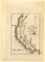
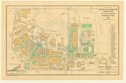
A plan of the several villages in the Illinois country, with part of the River Mississippi &c. London: 1788.
Cartographer:
Thomas Hutchins.
Engraver:
[John Norman?].
|
1788. |
Scale: 2.5 cm. = 10 mi.
Size: 18.3 x 12.7 cm.
|
(917.3: H97T) |
|
In: Thomas Hutchins, A topographical description of Virginia, opposite p. 41.
Wheat: 665
Provenance:
Presented by John Vaughan, 16 June 1815.
|
|
|
1270.
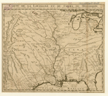
A map of the western part of the territories belonging to the United States of America. Drawn from the best authorities. [London: 1793].
Engraver:
T. Condor.
|
[1793]. |
Scale: 2.5 cm. = ca. 110 British statute mi.
Size: 34.9 x 33 cm.
|
(917.3: Im5) |
|
In: Gilbert Imlay, A topographical description, frontispiece.
|
|
|
1271.
N[orth] W[est] Territory. [1795].
|
[1795]. |
Scale: 2.5 cm. = 140 mi.
Size: 18.3 x 15.4 cm.
|
(Paine 68: Sco3u) |
|
In: Joseph Scott, The United States gazetteer , opposite "Territory North-West of the Ohio."
Wheat: 674
Provenance:
Presented by the Estate of Richard Gimbel, 1974.
|
|
|
1272.
N[orth] W[est] Territory. [1796].
Engraver:
W. Barker.
|
[1796]. |
Scale: 2.5 cm. = 130 mi.
Size: 19 x 14.8 cm.
|
(917.3: C25c) |
|
In: Mathew Carey, Carey's American pocket atlas , following p. 84.
Wheat: 675
Provenance:
Presented by Suzanne Wister Eastwick and Joseph L. Eastwick, July 1975.
|
|
|
1273.
Ohio River [by Andrew Ellicott]. Plates A and B. [Philadelphia: 1803].
Cartographer:
Andrew Ellicott.
Engraver:
A. Lawson.
|
[1803]. |
Sizes of plates: 32.7 x 46.5; 31.2 x 46.4 cm.
|
(635: [1803]: EL52ohr Small) |
|
See: Andrew Ellicott, Journal. . . Philadelphia: Dobson: 1803.
|
|
|
Great Lakes Area
|
|
|
|
|
1274.
A correct map of the seat of war. Published by John Conrad. Philadelphia: John Conrad; Baltimore: Fielding Lucas, Jr.: [ca. 1814].
Cartographer:
Samuel Lewis.
Engraver:
S. Harrison.
|
[ca.1814]. |
Scale: 1 in. = 42 mi.
Size: 40.2 x 58 cm.
Colored.
|
(635: [ca. 1814]: H243cmw Small) |
|
1275.
Map exhibiting the country between Lakes Michigan and Erie, and the contested boundary lines. By David H. Burr. New York: P. A. Mesier: [ca. 1820].
Cartographer:
David H. Burr.
Engraver:
P. A. Mesier.
|
[ca. 1820]. |
Size: 44.6 x 162.1 cm.
Colored.
|
(670: [ca. 1820]: B941Lme Large) |
|
Remarks on map refer to map by Thomas Hutchins, 1778.
|
|
|
1276.
Survey for a ship canal to connect the lakes Erie & Ontario. Lockport route. Surveyed under the direction of Capt. W. G. Williams, U.S. Top. Engrs. by Lieuts. T. F. Drayton & J. G. Reed. Map. no. 3.
N.p.: [1836].
Cartographer:
W. G. Williams, T. F. Drayton, and J. G. Reed.
|
[1836]. |
Scale: Horizontal scale—4 in. = 5,280 ft.
Size: 129.5 x 69.4 cm.
|
(670: [1836]: W678eon Large) |
|
Inset: Creek flowing into Niagara River.
With this is a profile of the Lockport route.
Provenance:
Presented by J. R. Ingersoll, 15 July 1836.
|
|
|
1277.
Map of that part of the mineral lands adjacent to Lake Superior, ceded to the United States by the treaty of 1842 with the
Chippewas. Comprising that district lying between Chocolate River and Fond du Lac, under the superintendency of Gen. John Stockton .
. . Projected and drawn under the direction of Lieut.-Col. George Talcott ... by A. B. Gray, assisted by John Seib. Compiled
from surveys and explorations made by direction of the U.S. War Department. . . ; from U.S. surveys made by Dr. Houghton and
Wm. A. Burt Esq.; from Nicollet's map of the upper Mississippi River; and Bayfield's charts of Lake Superior. Washington:
C. B. Graham Lith. Co.: [1847].
Cartographer:
Nicollet, Bayfield, George Talcott, A. B. Gray, John Sieb, Dr. Houghton, and William A. Burt.
Engraver:
C. B. Graham Lith. Co.
|
[1847]. |
Scale: 8.5 cm. = 20 mi.
Size: 90.1 x 115.5 cm.
Colored.
|
(626.2: [1845]: Un38mLs Large) |
|
Insets: Lake Superior; Vignette of Camp Gray, October 1st, 1844, near Talcott Harbor.
See accompanying report of 1845.
|
|
|
1278.
Kelley's and Bass Islands showing the harbors of refuge in their vicinity being an extract from the survey of the west end
of Lake Erie. U.S. War Department. Survey of the north and north western lakes. Under the orders of Lieut.-Col. Kearney, 1849. Washington:
1852.
Cartographer:
John Lambert, J. N. Macomb, Woodruff, Gunnison, Scammon, W. F. Smith, Burgess, Peter, Forster, and Kearney.
Engraver:
W. H. Dougal.
|
1852. |
Scale: 1:50,000.
Size: 50.8 x 62.9 cm.
|
(626.5: 1852: Un398kbi Large) |
|
1279.
West end of Lake Erie and Detroit River from surveys made under the direction of . . . Lieut. J. N. Macomb, I. C. Woodruff,
J. W. Gunnison, E. P. Scammon, R. W. Burgess, J. F. Peter, W. H. Warner, and J. H. Forster under Lt.-Col. James Kearney, 1849. U.S. War Department. Survey of the northern and north western lakes. [Washington: 1852].
Cartographer:
John Lambert, J. N. Macomb, I. C. Woodruff, J. W. Gunnison, E. P. Scammon, R. W. Burgess, J. F. Peter, W. H. Warner, J. H.
Forster, and James Kearney.
Engraver:
W. Smith.
|
[1852]. |
Scale: 1:120,000.
Size: 93.2 x 71.5 cm.
|
(626.5: [1852]: Un38edr Large) |
|
1280.
Lake Erie compiled from surveys made under the direction of the U.S. War Department. Survey of the northern and north western lakes. Bureau of Topographical Engineers. 1849. Reduced for engraving by John Lambert
. . . under the direction of Capt. T. J. Lee. Washington: 1853.
Cartographer:
John Lambert and T. J. Lee.
|
1853. |
Scale: 1:400,000.
Size: 61.3 x 99.5 cm.
|
(626.5: 1853: Un38Les Large) |
|
1281.
Head of Green Bay and entrance to Fox River, Wisconsin . . . surveyed in 1845 by Capt. W. G. Williams and Lieut. J. W. Gunnison
with corrections to date by Lieut. W. F. Raynolds, under the orders of Capt. J. N. Macomb. U.S. War Department. Survey of the northern and north western lakes. 1853. [Washington]: 1854.
Cartographer:
John Lambert, F. Herbst, W. G. Williams, J. W. Gunnison, W. F. Raynolds, and J. N. Macomb.
Engraver:
W. H. Dougal.
|
[1854]. |
Scale: 1:30,000.
Size: 49.5 x 67.5 cm.
|
(626.3: [1854]: Un38hgb Large) |
|
1282.
Preliminary chart of Eagle Harbor Lake Superior . . . Surveyed and drawn under the direction of Capt. J. N. Macomb by Lieut.
W. F. Raynolds assisted by J. U. Mueller, D. F. Henry and J. Wallace. U.S. War Department. Survey of the northern and north western lakes. 1855. [Washington: 1855].
Cartographer:
O. M. Poe, H. Gillman, J. N. Macomb, W. F. Raynolds, J. U. Mueller, D. F. Henry, and J. Wallace.
Engraver:
H. Dougal.
|
[1855]. |
Scale: 1:5,000.
Size: 51.7 x 73.6 cm.
|
(626.2: [1855]: Un38ehs Large) |
|
Inset: Eagle Harbor.
Provenance:
Presented by G. G. Meade, 19 July 1861.
|
|
|
1283.
Straits of Mackinac with the approaches thereto from Lakes Huron and Michigan and the entrance by the detour passage to the
St. Mary's River from trigonometrical surveys under . . . Lieut.-Col. James Kearney in 1849, and of Capt. J. N. Macomb in
1851, 1852, 1853 & 1854. U. S. War Department. Survey of the northern and north western lakes. [Washington: 1856].
Cartographer:
A. Boschke, James Kearney, and J. N. Macomb.
Engraver:
Selmar Siebert.
|
[1856]. |
Scale: 1:120,000.
Size: 55 x 103 cm.
|
(626.3: [1856]: Un38smm Large) |
|
1284.
Chart of St. Clair flats reduced from the original surveys of Capt. Geo[rge] G. Meade under the direction of Lieut.-Col. J.
Kearney .... Showing also the improvement at the mouth of the South Pass now being effected by the United States. U.S. War Department. Bureau of Topographical Engineers. 1857. [Washington: 1857].
Cartographer:
George G. Meade and J. Kearney.
Engraver:
W. H. Dougal.
|
[1857]. |
Scale: 1:32,000.
Size: 67.6 x 64.2 cm.
|
(626.4: [1857]: Un38scf Large) |
|
1285.
North end of Lake Michigan including the Beaver Island group from trigonometrical surveys under . . . Captain J. N. Macomb
in 1854 & 1855. U.S. War Department. Survey of the northern and north western lakes. [Washington: 1857].
Cartographer:
J. U. Müller and J. N. Macomb.
Engraver:
W. H. Dougal.
|
[1857]. |
Scale: 1:120,000.
Size: 60 x 90.5 cm.
|
(626.3: [1857]: Un38mbg Large) |
|
1286.
Preliminary chart of Tawas Harbor [Harbor of Refuge, Lake Huron]. U. S. War Department. Survey of the northern and north western lakes. Surveyed under the direction of Capt. J. N. Macomb,
G. W. Lamson, H. Gillman and A. G. Lamson. 1856. [Washington: 1857].
Cartographer:
J. N. Macomb, G. W. Lamson, H. Gillman, and A. G. Lamson.
Engraver:
W. H. Dougal.
|
[1857]. |
Scale: 1:16,000.
Size: 62.2 x 73 cm.
|
(626.4: [1857]: Un38thh Large) |
|
1287.
Maumee Bay surveyed and drawn under the direction of Capt. Geo. G. Meade in 1857. U.S. War Department. Survey of the northern and north western lakes. [Washington: 1858].
Cartographer:
G. G. Meade, J. H. Foster, W. H. Hearding, and P. C. Rabout.
Engraver:
W. H. Dougal.
|
[1857]. |
Scale: 1:30,000.
Size: 58.2 x 68.1 cm.
|
(626.5: [1858]: Un38mbe Large) |
|
1288.
Preliminary chart of Agate Harbor Lake Superior surveyed and drawn under the direction of Capt. J. N. Macomb . . . by Lieut.
W. F. Raynolds assisted by J. Mueller, D. F. Henry and J. Wallace in 1855. U.S. War Department. Survey of the lakes. Published under the supervision of Capt. G. G. Meade 1858. [Washington: 1858].
Cartographer:
C. P. Rabout, J. N. Macomb, W. F. Raynolds, J. Mueller, D. F. Henry, J. Wallace, and G. G. Meade.
Engraver:
W. H. Dougal.
|
[1858]. |
Scale: 1:10,000.
Size: 37.5 x 49.9 cm.
|
(626.2: [1858]: Un38cah Small) |
|
1289.
Preliminary chart of Eagle River Lake Superior surveyed and drawn under the direction of Capt. J. N. Macomb, by Lieut. W.
F. Raynolds assisted by J. Mueller, D. F. Henry and J. Wallace in 1855. U.S. War Department. Survey of the lakes. Published under the supervision of Capt. G. G. Meade 1859. [Washington: 1859].
Cartographer:
C. P. Rabaut, J. N. Macomb, W. F. Raynolds, J. Mueller, D. F. Henry, J. Wallace, and G. G. Meade.
Engraver:
W. H. Dougal.
|
[1858]. |
Scale: 1:10,000.
Size: 47.5 x 34.9 cm.
|
(626.2: [1859]: Un38eLs Small) |
|
1290.
Preliminary chart of Ontanogon Harbor Lake Superior . . . U.S. War Department. Survey of the northern and north western lakes. Surveyed and drawn under the direction of Capt. J. N. Macomb by Lieut. W.
F. Raynolds assisted by J. U. Mueller, D. F. Henry and J. Wallace. Reduced for publication, under the direction of Capt. G.
G. Meade, 1859. [Washington: 1859].
Cartographer:
Joshua Barney, J. N. Macomb, W. F. Raynolds, J.U. Mueller, D. F. Henry, J. Wallace, and G. G. Meade.
Engraver:
W. H. Dougal.
|
[1859]. |
Scale: 1:16,000.
Size: 36.7 x 53.1 cm.
|
(626.2: [1859]: Un38soh Small) |
|
1291.
General chart of Lake Huron projected from trigonometrical surveys under the orders of Capt. G. G. Meade and from other reliable
information, 1860. U.S. War Department. Surveys of the northern and north western lakes. [Washington: 1860].
Cartographer:
G. G. Meade and J. U. Mueller.
Engraver:
W. H. Dougal.
|
[1860]. |
Scale: 1:400,000.
Size: 90.3 x 67.3 cm.
|
(626.4: [I860]: Un38gch Large) |
|
1292.
Harbors of refuge Presqu'ile, False Presqu'ile, and Middle Island, Lake Huron. U.S. War Department. Survey of the northern and north western lakes. Projected from a trigonometrical survey executed under
the orders of Capt. G. G. Meade, 1858. [Washington: 1860].
Cartographer:
G. G. Meade.
Engraver:
W. H. Dougal.
|
[1860]. |
Scale: 1:40,000.
Size: 69.4 x 99.8 cm.
|
(626.4: [1860]: Un38ppm Large) |
|
1293.
Saginaw Bay and part of Lake Huron projected from a trigonometrical survey under the orders of Capt. J. N. Macomb in 1856,
and of Capt. G. G. Meade in 1857 & 1858. U. S. War Department. Survey of the northern and north western lakes. [Washington: 1860].
Cartographer:
J. U. Mueller, J. N. Macomb, and G. G. Meade.
Engraver:
W. H. Dougal.
|
1860. |
Scale: 1:120,000.
Size: 74 x 110 cm.
|
(626.4: 1860: Un38sbh Large) |
|
1294.
Thunder Bay, Lake Huron projected from a trigonometrical survey executed under the orders of Capt. Geo. G. Meade in 1858. U. S. War Department. Survey of the northern and north western lakes. [Washington: 1860].
Cartographer:
Joshua Barney and George G. Meade.
Engraver:
W. H. Dougal.
|
[1860]. |
Scale: 1:40,000.
Size: 74.1 x 88.4 cm.
|
(626.4: [1860]: Un38tbh Large) |
|
1295.
Chart of the lights on the lake coast of the United States. Published by the order and under the direction of the U.S. Light House Board. Prepared at the office of the survey of the
northern and north western lakes under the supervision of Capt. Geo. G. Meade. N.p.: 1861.
Cartographer:
Geo. G. Meade.
|
1861. |
5 pieces.
Scale: 1:600,000.
Sizes: Various.
Colored.
|
(670: 1861: Un48Lhb Large) |
|
|
|
|
1296.
South end of Lake Huron and head of the St. Clair River projected from a trigonometrical survey, executed under the orders
of Capt. Geo. G. Meade in 1859. U.S. War Department. Survey of the northern and north western lakes. [Washington: 1861].
Cartographer:
Joshua Barney and G. G. Meade.
Engraver:
William H. Dougal.
|
[1861]. |
Scale: 1:120,000.
Size: 69 x 68.2 cm.
|
(626.4: [1861]: Un38sLh Small) |
|
Inset:Head of St. Clair River showing the anchorage ground.
|
|
|
1297.
Preliminary chart of Grand Island and its approaches, Lake Superior, projected from a trigonometrical survey, executed under
the orders of Capt. Geo[rge] G. Meade, 1859. U.S. War Department. Survey of the northern and north western lakes. [Washington: 1862].
Cartographer:
George G. Meade and Joshua Barney.
Engraver:
W. H. Dougal.
|
1862. |
Scale: 1:25,000.
Size: 92.9 x 72.3 cm.
|
(626.2: 1859: Un38gis Large) |
|
1298.
Section of the lake, river and canal navigation for Lake Superior to the Gulf of St. Lawrence. [ca. 1869].
Cartographer:
E. Blackwell.
|
[ca.1869]. |
Scales: Horizontal, 1 in. = 60 mi. Vertical, 1 in. = 400 ft.
Size: 23 x 85.4 cm.
Colored.
Size of paper: 36.3 x 93.1 cm.
|
(670: [ca. 1869]: B561Lsg Large) |
|
For text, see: APS, Transactions. Ser. 2, vol. 13, 1869.
With this is a water color painting of "Sketch from the Mountain of Montreal showing part of the plain extending south east
& southwards to the Green Mountain Range in Eastern townships of Canada and Vermont & the Adirondack Mountain regions of New
York. To illustrate Mr. Blackwell's paper on the basin of the St. Lawrence."
|
|
|
1299.
Coast Chart No. 5. Lake Superior from Ontonagon to Oronto Bay and Outer Island prepared under the direction of Colonel Mason M. Patrick . .
. 1915-1916 from U.S. Lake Surveys made between the years 1868 and 1905. U.S. War Department. Army. Survey of the northern
and northwestern lakes. Issued August 9, 1916. [Washington]: 1916.
Cartographer:
Mason M. Patrick.
Engraver:
G. F. Penner.
|
1916. |
Scale: 1:120,000.
Size: 71.1 x 80.9.
Colored.
|
(626.2: 1916: Un38soo Large) |
|
Inset:Ontonagon harbor, Michigan.
|
|
|
1300.
General chart of the northern and northwestern lakes including New York state canals and Lake Champlain prepared from the
latest U.S. lake survey . . . and first issued under the direction of Col. G. J. Lydecker, and Major Charles Keller . . .
in 1906-1907. U.S. War Department. Army Corps of Engineers. Survey of the northern and north western lakes. Issued June 26, 1916. Catalogue
No. O. [Washington]: 1916. Fifth edition.
Cartographer:
G. J. Lydecker and Charles Keller.
|
1916. |
Scale: 1:1,200,000.
Size: 78.1 x 125.7 cm.
Colored.
|
(620: 1916: Un38Lny Large) |
|
1301.
Lake Ontario prepared from a trigonometrical survey in 1873-1875 and first issued under the direction of Major C. B. Comstock,
U.S. War Department. Survey of the northern and north western lakes. Revised from results of surveys by the U.S. Lake Survey and the Canadian
Government . . . Issued 7 October 1916. Catalogue No. 2. [Washington]: 1916. Sixth edition (in colors).
Cartographer:
Edward Molitor and C. B. Comstock.
|
1916. |
Scale: 1:400,000.
Size: 51.9 x 87.5 cm.
Colored.
|
(626.6: 1916: Un38wLo Large) |
|
Ohio
|
|
|
|
|
1302.
A topographical plan of that part of the Indian-country through which the army under the command of Colonel Bouquet marched
in the year 1764. [1765].
Cartographer:
Thomas Hutchins, Guy Johnson, and Bernard Ratzer.
Engraver:
Henry Dawkins (?).
|
[1765]. |
Scale: 2.5 cm. = 6 mi.
Size: 36.2 x 49.3 cm.
|
(973.2: Sm6) |
|
Inset: A general map of the country on the Ohio and Muskingham shewing the situation of the Indian-towns with respect to the army
under the command of Colonel Bouquet.
In: William Smith, An historical account of the expedition, frontispiece.
Wheat: 658
|
|
|
1303.
A map of the federal territory [Ohio] from the western boundary of Pennsylvania to the Scioto River; laid down from the latest
informations and divided into townships and fractional parts of townships agreeably to the Ordinance of the Honle. Congress
passed in May 1785. N.p.: 1785.
|
1785. |
Scale: 2.5 cm. = 10 mi.
Size: 65.9 x 48.9 cm.
Colored.
|
(672: 1785: Un38fed Large) |
|
To accompany Manasseh Cutler, Explanation of the map of the federal lands confirmed by the treaties of 1784. Salem: 1787.
Wheat: 662
|
|
|
1304.
A plan of the rapids in the River Ohio. [1787].
Cartographer:
Thomas Hutchins.
Engraver:
John Cheevers.
|
[1787]. |
Scale: 2.5 cm. = 80 yd.
Size: 14.7 x 18.5 cm.
|
(917.3:H97t [London edition]) |
|
In: Thomas Hutchins, A topographical description of Virginia, opposite p. 8.
Wheat: 664
Provenance:
Presented by John Vaughan, 16 June 1815.
|
|
|
1305.
Plan of the remains of some ancient works on the Muskingum. [1787].
Cartographer:
Jona. Heart.
|
[1787]. |
Scale: 2.5 cm. = 10 chains.
Size: 17.2 x 21.6 cm.
|
(050: C72) |
|
In: Columbian Magazine, vol. 1, following p. 424.
Wheat: 663
|
|
|
1306.
A plan of Campus Martius, at the city of Marietta, territory of the United States, N.W. of the River Ohio. [1788].
|
[1788]. |
Scale: 2.5 cm. = 40 ft.
Size of plate: 17.5 x 15.2 cm.
|
(050: C72) |
|
In: Columbian Magazine , vol. 2, opposite p. 646.
Wheat: 668
|
|
|
1307.
Indian works, on Huron River or Bald Eagle Creek. [Ohio, 1789].
|
[1789]. |
Size of page: 10.6 x 19.5 cm.
|
(050: C72) |
|
In: Columbian Magazine , vol. 3, opposite p. 543.
Wheat: 669
|
|
|
1308.
A plan of the rapids of the Ohio. [1793].
Engraver:
T. Condor.
|
[1793]. |
Scale: 2.5 cm. = 800 yd.
Size: 15 x 18.4 cm.
|
(917.3: Im5 [London edition]) |
|
In: Gilbert Imlay, A topographical description, opposite p. 51.
Wheat: 672
|
|
|
1309.
A map of the state of Ohio, from actual survey. By B. Hough & A. Bourne. Chillicothe: B. Hough & A. Bourne. Philadelphia: J. Melish: 1815 [1 May 1815].
Cartographer:
B. Hough and A. Bourne.
Engraver:
H. S. Tanner.
|
1815. |
Scale: 1 degree = 69½ mi.
Size: 125.7 x 114.7 cm.
Colored.
|
(672: 1815: H813mso Large) |
|
1310.
State of Ohio. Chart of the entrance of Sandusky-Bay. U.S. Topographical Engineers. Reduced from the original survey of Lieut. C[ampbell]
Graham of 1826, under the direction of Col. Jno. J. Abert. . . by Wash: Hood. [Washington]: 1838.
Cartographer:
John J. Abert, Campbell Graham, and Wash. Hood.
Engraver:
W. J. Stone.
|
1826. |
Scale: 4 in. = 1 mi.
Size: 54 x 41.7 cm.
|
(672: 1826: Un38csb Small) |
|
Inset: Map of Sandusky Bay.
See: U.S. 25th Congress. 2nd Session. Document no. 399.
Provenance:
Presented and endorsed by J. D. Graham, 18 June 1841; and Hartman Bache, 17 August 1838.
|
|
|
1311.
Ohio. By David H. Burr. New York: J. H. Colton & Co.: 1833.
Cartographer:
David H. Burr.
Engraver:
S. Stiles & Co.
|
1833. |
Scale: 1 in. = 15 mi.
Size: 47.5 x 57.3 cm.
Colored.
|
(672: 1833: B941moc Large) |
|
Inset: A plan of Cincinnati.
|
|
|
1312.
Climatological map of the state of Ohio. By Lorin Blodget. N.p.: 1872.
Cartographer:
Loren Blodget.
|
1872. |
Size: 37 x 27.7 cm.
Colored.
|
(672: 1872: B621cmo Small) |
|
See: H. F. Walling and O. W. Gray, New topographical atlas of the state of Ohio. Cincinnati: Stedman, Brown & Lyon: 1872.
|
|
|
1313.
State of Ohio. U.S. Department of the Interior. Compiled from the official records of the General Land Office and other sources by C. Roeser.
New York: Julius Bien: [1878].
Cartographer:
C. Roeser.
Engraver:
Julius Bien.
|
[1878]. |
Scale: 1 in. = 10 mi.
Size: 63.5 x 72.6 cm.
Colored.
|
(672: [1878]: Un38gLo Large) |
|
1314.
A geological and topographical sketch of the Hinckley coal tracts, in Brookfield Township, Trumbull County, Ohio. By Benj. Smith Lyman. New York: J. Bien: 1883.
Cartographer:
Benjamin Smith Lyman.
Engraver:
Julius Bien.
|
1883. |
Scale: 1:18,000.
Size: 44.8 x 33.2 cm.
|
(672: 1883: L995hct Small) |
|
1315.
Topographic sheet of Ohio-Kentucky. Cincinnati Quadrangle. U.S. Geological Survey. Charles D. Walcott, Director. [Washington]: 1900.
Cartographer:
Jno. H. Renshawe, Geo. T. Hawkins, W. J. Peters, Chas. E. Cooke, and Charles D. Walcott.
Engraver:
U.S. Geological Survey.
|
1900. |
Scale: 1:62,500.
Size: 44.4 x 69.5 cm.
Colored.
|
(672: 1900: Un38cqo Large) |
|
1316.
State of Ohio. U.S. Department of the Interior. Compiled from the official records of the General Land Office and other sources under the
direction of I. P. Berthrong. Washington: Eckert: 1910.
Cartographer:
I. P. Berthrong and A. F. Dinsmore.
Engraver:
Eckert Lithograph. Co.
|
1910. |
Scale: 1 in. = 12 mi.
Size: 54.4 x 60.5 cm.
Colored.
|
(672: 1910: Un38soo Large) |
|
1317.
Railroad map of Ohio. Published by the state. Columbus, Ohio: Columbus Lithog. Co.: 1914.
Engraver:
Columbus Lithograph Company.
|
1914. |
Scale: 1¼ in. = 10 mi.
Size of paper: 82.3 x 72.3 cm.
Colored.
|
(672: 1914: Oh36rrc Book map) |
|
Indiana
|
|
|
|
|
1318.
State of Indiana. U.S. Department of the Interior. Compiled from the official records of the General Land Office and other sources by Geo.
U. Mayo. Washington: Graham: 1886.
Cartographer:
Geo. U. Mayo and M. Hendges.
Engraver:
A. B. Graham Co.
|
1886. |
Scale: 1 in. = 12 mi.
Size: 63.3 x 44.5 cm.
Colored.
|
(673: 1886: Un38soi Large) |
|
1319.
State of Indiana. U.S. Geological Survey. George Otis Smith, Director. [Washington]: U.S. Geological Survey: 1909-1910.
Cartographer:
George Otis Smith, R. B. Marshall, and A. F. Hassan.
Engraver:
U. S. Geological Survey.
|
1909-1910. |
Scale: 1:500,000.
Size: 91.8 x 59.7 cm.
|
(673: 1909-1910: Un38int Large) |
|
1320.
State of Indiana. U.S. Department of the Interior. Compiled from official records of the General Land Office, U.S. Geological Survey and other
sources under the direction of I. P. Berthrong. Washington: 1916.
Cartographer:
I. P. Berthrong, A. F. Dinsmore, and Thomas O. Wansleben.
Engraver:
Eckert Lithographic Company.
|
1916. |
Scale: 1:760,320.
Size: 62.9 x 43.9 cm.
Colored.
|
(673: 1916: Un38inb Small) |
|
Illinois
|
|
|
|
|
1321.
A plan of the several villages in the Illinois country, with part of the River Mississippi &c. By Thos. Hutchins. [London: J. Almon: 1778].
Cartographer:
Thomas Hutchins.
|
[1778]. |
Scale: 1 in. = 10 mi.
Size: 18.1 x 12.9 cm.
|
(674: [1778]: H973vmr Small) |
|
See: A topographical description of Virginia, Pennsylvania, Maryland and North Carolina, by Thos. Hutchins. London: J. Almon: 1778.
|
|
|
1322.
The tourist's pocket map of the state of Illinois, exhibiting its internal improvements; roads, distances, etc. By J. H. Young. Philadelphia: S. Augustus Mitchell: 1836.
Cartographer:
J. H. Young.
Engraver:
E. F. Woodward.
|
1836. |
Scale: 1 in. = 30 mi.
Size: 39.2 x 32.5 cm.
Colored.
|
(674: 1836: Y79stLL Book map) |
|
Inset: Map of the lead mine region east of the Mississippi River.
|
|
|
1323.
Diagram of the state of Illinois. No. 2. (A) [Washington: 1838].
Engraver:
W. J. Stone.
|
[1838]. |
Scale: 1 in. = 18 mi.
Size of paper: 66.1 x 39.6 cm.
Colored.
|
(674: [1838]: Un38dsi Large) |
|
See: U.S. 25th Congress. 3rd Session. Senate document 17, no. 10.
|
|
|
1324.
New sectional [pocket] map of the state of Illinois. Compiled from the United States surveys. Also exhibiting the internal improvements, distances between towns, villages & post
offices, the outlines of prairies, woodlands, marshes, & the lands donated to the state by the Gen[era]l Gov[ernmen]t for
the purpose of internal improvements. By J. M. Peck, John Messenger and A. J. Mathewson. New York: J. H. Colton & Co.: 1853.
Cartographer:
J. M. Peck, John Messenger, and A.J. Mathewson.
Engraver:
S. Stiles & Co.
|
1853. |
Scale: 1 in. = 10 mi.
Size: 103.6 x 69.4 cm.
Colored.
|
(674: 1853: C672sec Book map) |
|
Insets: Vicinity of Alton and St. Louis; vicinity of Galena, the lead region.
|
|
|
1325.
Chart of the harbor & river of Chicago, from surveys made in Aug[us]t 1854 under the superintendence of Brevet Lt. Col. Graham. Sheet G. No. 12. Chicago: H. Acheson: [1854].
Cartographer:
J. D. Graham.
Engraver:
H. Acheson.
|
[1854]. |
Scale: 1 in. = 200 ft.
Size: 55.7 x 72.1 cm.
|
(674: [1854]: Un38chr Large) |
|
Accompanies J.D. Graham's report (no. 32) to the Chief Topographical Engineer dated 19 August 1854. Published for the Board
of Trade of Chicago.
Graham wrote that he was presenting several charts:
1. A chart, (marked G. No. 12) of Chicago harbor, shewing its condition and the facilities of entrance produced by dredging
on the bar, under my direction in the summer of 1854. Before the dredging, the bar was very much in the same condition as
it is shewn in the next succeeding map marked G No. 38 [map no. 1325].
2. A map marked G No. 38 of Chicago harbor and bar, shewing their condition on the 9th of April 1856. The re-formation at
the bar, at the harbor entrance, between August 1854 and April 1856, is here clearly shewn. The positions of the block-house
and other buildings of Old Fort Dearborn in 1856, now no longer existing, are shewn on this map.
They have all yielded to the progress of improvement in the rapidly increasing City of Chicao [map no. 1326].
3. Map G. No. 43 Chicago harbor, shewing its condition and the remnant of the bar on the 15th of September 1856 after the
dredging (done for the second time under my direction) between April 22d and September 15th 1856.
4. Map G No. 44. Chicago harbor & Bar, shewing the effect of the violent gales of wind in October 1856, in diminishing the
depth of water on the bar. This map shews the actual condition of the harbor & bar on the 14th of November 1856, from careful
survey ending on that day.
All of the above mentioned maps based on careful triangulations made under my direction, and the harbors mentioned are all
on Lake Michigan.
I will add that these maps are all referred to in my reports on lake harbor improvements which I have sent to the Society's
library . . .
P.S.: Maps 43 and 44 shew the position to be occupied by the new light house now being constructed for Chicago harbor. It
is immediately to the north of the extremity of the north harbor-pier [Archives. J. D. Graham to C. B. Trego, 10 March 1858.
Minutes. Proceedings , vol. 6, p. 309. Donation book for 16 April 1858].
Provenance:
Presented by J.D. Graham, 10 March 1858.
|
|
|
1326.
Chicago Harbor and Bar, Illinois. U.S. Topographical Engineers. From survey made between March 29th & April 9th, 1856. Under the direction of Brevet Lt. Col.
J. D. Graham. Map G no. 38. Chicago: Ed. Mendel: [1856].
Cartographer:
J. D. Graham.
Engraver:
Ed. Mendel.
|
[1856]. |
Scale: 1 in. = 200 ft.
Size: 58.6 x 77 cm.
|
(674: [1856]: Un38chb Large) |
|
See: Map no. 1325 for Graham's comments on this map.
Provenance:
Presented by J. D. Graham, 10 March 1858.
|
|
|
1327.
State of Illinois, U.S. Department of the Interior. Compiled from the official records of the General Land Office and other sources under the direction of I. P. Berthrong. Washington:
Eckert: 1911.
Cartographer:
Charles J. Helm and I. P. Berthrong.
Engraver:
Eckert Litho. Co.
|
1911. |
Scale: 1 in. = 12 mi.
Size: 83.6 x 49 cm.
Colored.
|
(674: 1911: Un38gLo Large) |
|
1328.
State of Illinois. U.S. Department of the Interior. Geological Survey. George Otis Smith, Director. [Washington]: U.S. Geological Survey: 1915.
Cartographer:
George Otis Smith.
Engraver:
U.S. Geological Survey.
|
1915. |
Scale: 1:1,000,000.
Size: 63 x 36.6 cm.
|
(674: 1915: Un38ssi Small) |
|
Mississippi River
|
|
|
|
|
1329.
[Section of the Mississippi River. By Andrew Ellicott]. No. 2. [Philadelphia: 1803].
Cartographer:
Andrew Ellicott.
Engraver:
Alexander Lawson.
|
[1803]. |
Size: 21.1 x 42.3 cm.
|
(630: [1803]: EL52mr Small) |
|
Original in: Andrew Ellicott, Journal. . . Philadelphia: Dobson: 1803.
|
|
|
1330.
Map of the Mississippi River from its source to the mouth of the Missouri: laid down from the notes of Lieut. Z. M. Pike,
by Anthony Nav. Reduced, and corrected by the astronomical observations of Mr. Thompson at its source: and of Capt. M. Lewis,
where it receives the waters of the Missouri. [1807].
Cartographer:
Anthony Nav, Z. M. Pike, Mr. Thompson, and M. Lewis.
Engraver:
Francis Shallus.
|
[1807]. |
Scale: 1 in. = 25 mi.
Size: 23.5 x 77.5 cm.
|
(633: [1807]: K584mrm Large) |
|
See: Zebulon M. Pike's Account of a voyage up the Mississippi River. Washington: 1807, and Account of expeditions to the source of the Mississippi. Philadelphia: 1810.
Provenance:
Presented by Thomas Jefferson, 1807.
|
|
|
1331.
Map of the Des Moines Rapids of the Mississippi River. No. 1. U.S. Corps of Engineers. Drawn by Lt. M. C. Meigs and Henry Kayser. Surveyed by Lt. R. E. Lee, M. C. Meigs, Henry
Kayser and J. S. Morehead. September 1837. [Washington: 1837].
Cartographer:
R. E. Lee, J. S. Morehead, M. C. Meigs, and Henry Kayser.
Engraver:
W. J. Stone.
|
[1837]. |
Scale: 5 in. = 1 mi.
Size of paper: 59.4 x 141.2 cm.
|
(678: [1837]: Un38dmr Large) |
|
In: A collection of maps, etc., published by order of Congress. Washington: 1843. Senate. Documents, no. 139. 25th Congress. 2nd Session.
|
|
|
1332.
Map of the Rock Island Rapids of the Mississippi River. U.S. Corps of Engineers. No. 2. Surveyed by Lt. R. E. Lee, etc. in Sept[embe]r and Oct[obe]r 1837. [Washington: 1837].
Cartographer:
R. E. Lee, M. C. Meigs, J. S. Morehead, and Henry Kayser.
Engraver:
W. J. Stone.
|
[1837]. |
Scale: 1 in. = 16 chains.
Size of paper: 53.3 x 170.6 cm.
|
(674: [1837]: Un38rir Large) |
|
In: U.S. 25th Congress. 2nd Session. Senate. Documents, no. 139.
Provenance:
Presented by J. T. Abert.
|
|
|
1333.
Mississippi River, Louisiana. From New Orleans to Soniat Plantation, including Carrollton, Jefferson and Kennerville. U.S. Coast Survey Sheet no. 8. [Washington]:
1878.
Cartographer:
C. P. Patterson, C. H. Boyd, and A. McCrackin.
|
1878. |
Scale: 1:20,000.
Size: 58 x 83.7 cm.
|
(666: 1878: Un38mrs Large) |
|
Inset: Diagram of sheets.
Provenance:
Presented by U.S. Coast and Geodetic Survey through Spencer C. McCorkle, 14 December 1885.
|
|
|
1334.
Atlas illustrating report of March 20, 1909, of Board on examination and survey of Mississippi River created by Act of Congress,
approved March 2, 1907. [1893].
|
[1893]. |
52 maps.
Size: 63.7 x 101.5 cm.
Colored.
|
(630: [1893]: P18msra Large) |
|
Accompanies U.S. 61st Congress. 1st Session. House of Representatives. Documents, no. 50.
|
|
|
1335.
Survey of the Mississippi River. Published by the Mississippi River Commission. 1893-1907. Nos. 101-144.
Cartographer:
C. W. Clark.
|
1893-1907. |
Scale: 1 in. = 1 mi.
Size: 31.5 x 57 and 32 x 57.5 cm.
|
(630: 1893-1907: P181msr Large) |
|
Traces the course of the river from Wisconsin to its junction with the Ohio River.
|
|
|
1336.
Survey of the Mississippi River [New Orleans sections] made under the direction of the Mississippi River Commission. Chart no. 76. Projected from a trigonometrical survey made by the U.S. Coast Survey in 1874. N.p.: [1893].
Cartographer:
Carl F. Palfrey, J. G. Warren, Geo. A. Zinn, C. H. Boyd, James A. Paige, E. J. Thomas, A. T. Morrow, W. S. Williams, W. H.
Roper, W. G. Comber, G. H. French, E. L. Harman, H. Dunaway, C. L. Ockerson, O. N. Axtell, C. G. Weyl, C. A. Bonfils, T C.
Hockridge, Geo. H. Wolbrecht, K. A. Widen, C. R. Appiano, H. A. H. d'Ailly, and A. W. Swanitz.
|
[1893]. |
4 sheets.
Scale: 1:10,000.
Size of each: 58.6 x 93.9 cm.
|
(630: [1893]: P181msr Extra-Oversize) |
|
1337.
District map of the lower Mississippi River published by the Mississippi River Commission. U.S. Corps of Engineers. H. E. Waterman . . . Secretary. [New York: J. Bien & Co.]: 1897.
Cartographer:
H. A. H. d'Ailly.
Engraver:
J. Bien.
|
1897. |
Scale: 1 in. = 5 mi.
Size: 92.6 x 76.7 cm.
Colored.
|
(634: 1897: Un38mis Large) |
|
On left side of map is: Table of midstream distances from Cairo to Head of Passes.
|
|
|
1338.
Survey of the Mississippi River made under the direction of the Mississippi River Commission. 1898. New York: Julius Bien & Co.: 1898. Charts nos. 201-242.
Cartographer:
H. E. Waterman, Mason M. Patrick, et al.
|
1898. |
Scale: 1:10,000.
Size of each: ca. 58.3 x 94 cm.
|
(630: 1898: W311msr Extra-Oversize) |
|
1339.
Map of the alluvial valley of the upper Mississippi River from the Falls of St. Anthony to the mouth of the Ohio River. Showing lands subject to overflow, bluff lines defining the limit of the alluvial valley, location of levees and trans-valley
profiles. U.S. Corps of Engineers. Published by the Mississippi River Commission. New York: Julius Bien: 1899.
Cartographer:
Mason M. Patrick, J. A. Ockerman, C. W. Clark, H. A. H. d'Ailly, and A. A. Aguirre.
Engraver:
Julius Bien.
|
1899. |
4 sheets.
Scale: 1:316,800.
Size of each: 70.3 x 125.5 cm.
Colored.
|
(670: 1899: P278msr Extra-Oversize) |
|
1340.
Survey of the Mississippi River. Made under the direction of the Mississippi River Commission. U.S. Corps of Engineers. Lake Itasca basin, Minnesota, within
Itasca State Park. Projected from a trigonometrical survey made in 1900. New York: Bien: [1900].
Cartographer:
C. W. Clark, K. A. Widen, and H. A. H. d'Ailly.
Engraver:
Julius Bien.
|
[1900]. |
Scale: 1:15,000.
Size: 58.6 x 93.7 cm.
Colored.
|
(677: [1900]: Un38ibm Large) |
|
1341.
Map of the alluvial valley of the Mississippi River from the head of the St. Francis Basin to the Gulf of Mexico, showing
lands subject to overflow, location of levees and trans-alluvial profiles. Published by the Mississippi River Commission. 1887. 3rd ed. 1907. N.p.: 1907.
Cartographer:
C. B. Comstock, Henry M. Adams, A. A. Humphreys, H. L. Abbot, Amos Stickney, C. B. Sears, J. G. D. Knight, Smith S. Leach,
T. G. Dabney, William Starling, H. B. Richardson, C. W. Babbitt, Thomas Turtle, Edward Molitar, and C. W. Clark.
|
1907. |
8 sheets.
Scale: 1:316,800.
Size of each sheet: ca. 86.5 x 64.5 cm.
Colored.
|
(670: 1907: C738msr Extra-Oversize) |
|
1342.
Map of the Saint Francis Basin in two parts. Mississippi River Commission. 1903. New York: J. Bien: 1907.
Cartographer:
Mason M. Patrick, George P. Howell, and C. W. Clark.
Engraver:
J. Bien.
|
1907. |
Scale: ½ in. = 1 mi.
Size: 129.5 x 69.9 cm.
Colored.
|
(670: 1907: P278msr Large) |
|
1343.
Atlas illustrating report of March 20, 1909, of Board on examination and survey of Mississippi River. Created by Act of Congress approved March 2, 1907. N.p.: [1909].
|
[1909]. |
52 plates.
Size: 63.3 x 101.8 cm.
|
(630: [1909]: M695msr Large) |
|
See: U.S. 61st Congress. House of Representatives. Documents, no. 50. U.S. Engineer Department . . . Report of a special board of engineers on survey of the Mississippi River. Washington: 1909.
|
|
|
Michigan
|
|
|
|
|
1344.
Black Lake Harbor, Michigan. U.S. Topographical Engineers. From survey made between the 12th. & 29th. September 1856 by Assistant John R. Mayer under the direction of Brevet Lt. Col.
J. D. Graham. Map G. No. 48. Chicago: Ed. Mendel: [1856].
Cartographer:
John R. Mayer and J. D. Graham.
Engraver:
Ed. Mendel.
|
[1856]. |
Scale: 1 in. = 200 ft., or 1:2400.
Size: 65 x 92.3 cm.
|
(675: [1856]: Un38bLm Large) |
|
This accompanies J. D. Graham's annual report, no. 161, to the Chief Topographical Engineer from Chicago, 15 November 1856.
Provenance:
Presented by J. D. Graham, 10 March 1858.
|
|
|
1345.
Grand River Harbor, including part of the town of Grand Haven, Michigan. U.S. Topographical Engineers. From survey made in October 1856 by Assistant John R. Mayer under the direction of Brevet Lieut.
Col. J. D. Graham. Map G. No. 49. Chicago: Ed. Mendel: [1856].
Cartographer:
John R. Mayer and J. D. Graham.
Engraver:
Ed. Mendel.
|
[1856]. |
Scale: 1 in. = 200 ft., or 1:2400.
Size: 64.5 x 99.9 cm.
|
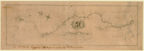
(675: [1856]: Un38grh Large) |
|
This accompanies J. D. Graham's annual report, no. 161, to the Chief Topographical Engineer, 15 November 1856.
Provenance:
Presented by J. D. Graham, 10 March 1858.
|
|
|
1346.
Mouth of Kalamazoo River, Michigan. U.S. Topographical Engineers. From survey made between the 2d. & 10th. September 1856 by Assistant John R. Mayer under the
direction of Brevet Lieut. Col. J. D. Graham. Map G. No. 51. Chicago: Ed. Mendel, lith.: [1856].
Cartographer:
J. D. Graham and John R. Mayer.
Engraver:
Ed. Mendel.
|
[1856]. |
Scale: 1 in. = 200 ft., or 1:2400.
Size: 60.8 x 91.9 cm.
|
(675: [1856]: Un38mkr Large) |
|
This accompanies J. D. Graham's annual report, no. 200, to the Chief Topographical Engineer, Chicago, 30 September 1857.
Provenance:
Presented by J. D. Graham, 10 March 1858.
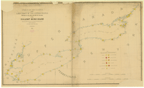
|
|
|
1347.
St. Joseph Harbor, Michigan. U.S. Topographical Engineers. From survey made between the 14th. & 27th. August 1856 by Assistant John R. Mayer under the
direction of Brevet Lieut. Col. J. D. Graham. Map G. No. 47. Chicago: Ed. Mendel: [1856].
Cartographer:
John R. Mayer and J. D. Graham.
Engraver:
Ed. Mendel.
|
[1856]. |
Scale: 1 in. = 200 ft., or 1:2,400.
Size: 66.5 x 96.5 cm.
|
(675: [1856]: Un38sjh Large) |
|
Accompanies J. D. Graham's annual report, no. 161, to the Chief Topographical Engineer, 15 November 1856.
Provenance:
Presented by J. D. Graham, 10 March 1858.
|
|
|
1348.
Mouth of South Black River, Michigan. U.S. Topographical Engineers. From survey made in August 1856 by Assistant John R. Mayer under the direction of Brevet Lieut.
Col. J. D. Graham. Map G. No. 50. Chicago: Ed. Mendel: [1857].
Cartographer:
John R. Mayer and J. D. Graham.
Engraver:
Ed. Mendel.
|
1857. |
Scale: 1 in. = 200 ft., or 1:2,400.
Size: 51.7 x 70.7 cm.
|
(675: 1857: Un38msb Large) |
|
Accompanies J. D. Graham's annual report, no. 200, to the Chief Topographical Engineer, Chicago, 30 September 1857.
Provenance:
Presented by J. D. Graham, 10 March 1858.
|
|
|
1349.
New Buffalo, and the marshes of Lake Pottowottomee at the mouth of the Galien River, Michigan. U.S. Topographical Engineers. Shewing the facilities of constructing a harbor of refuge. From survey made in September 1857,
by Assistant John R. Mayer, under the direction of Brevet Lieut. Col. J. D. Graham. Map G. No. 54. Chicago: Ed. Mendel: [1857].
Cartographer:
John R. Mayer and J. D. Graham.
Engraver:
Ed. Mendel.
|
[1857]. |
Scale: 1 in. = 200 ft., or 1:2,400.
Size: 65.8 x 101.2cm.
|
(675: [1857]: Un38bpg Large) |
|
Accompanies J. D. Graham's annual report, no. 200, to the Chief Topographical Engineer, Chicago, 30 September 1857.
Provenance:
Presented by J. D. Graham, 10 March 1858.
|
|
|
1350.
State of Michigan. U.S. Department of the Interior. Compiled from the official records of the General Land Office and other sources under the
direction of Frank Bond. [Washington: 1904].
Cartographer:
Frank Bond and Charles J. Helm.
|
1904. |
Scale: 1 in. = 16 mi.
Size: 77 x 65 cm.
Colored.
|
(675: 1904: Un38mic Large) |
|
1351.
Geological map of Michigan. Geological and biological survey of Michigan. Compiled by R. C. Allen, R. A. Smith, and L. P. Barrett, from surveys by the Michigan Geological Survey and the U.S. Geological
Survey. 1916. Publication XXIII. Baltimore: A. Hoen, Lith.: 1916.
Cartographer:
R. C. Allen, R. A. Smith, and L. P. Barrett.
Engraver:
A. Hoen, lithographer.
|
1916. |
Scale: 1:750,000.
Size: 104 x 86.1 cm.
Colored.
|
(675: 1916: M585geo Large) |
|
1352.
The centennial geological map of the northern peninsula of Michigan. Michigan Department of Conservation. Geological Survey Division, R. A. Smith, State Geologist. Compiled by Helen M. Martin
1936. N.p.: [1936].
Cartographer:
R. A. Smith and Helen M. Martin.
|
1936. |
Scale: 1:500,000.
Size: 79 x 108.4 cm.
Size of paper: 86.6 x 137.4 cm.
Colored.
|
(675: 1936: Sm51nop Large) |
|
Along left side is a legend describing the map.
Publication 39, Geological series 33. A part of the annual report for 1936.
|
|
|
1353.
The centennial geological map of the southern peninsula of Michigan. Michigan Department of Conservation. Geological Survey Division, R. A. Smith, State Geologist. Compiled by Helen M. Martin
1936. N.p.: [1936].
Cartographer:
R. A. Smith and Helen M. Martin.
|
1936. |
Scale: 1¼ in. = 10 mi.
Size: 101.8 x 75.2 cm.
Size of paper: 117 x 104.5 cm.
Colored.
|
(675: 1936: Sm51sop Small) |
|
Along the left side is a legend describing the map; at the bottom is a chart of rocks of different periods.
|
|
|
Minnesota
|
|
|
|
|
1354.
A reconnaissance of the Minnay Sotor Watapah; or St. Peter's River to its sources: made in the year 1835. [By G. W. Featherstonhaugh].
Cartographer:
G. W. Featherstonhaugh.
|
[1835]. |
Scale: 1 in. = 8 mi.
Size: 59.3 x 107.4 cm.
|
(677: [1835]: Un38msw Large) |
|
Accompanies: "Report of a geological reconnaissance made in 1835 from the seat of government, by way of the Green Bay and
the Wisconsin territory, to the Coteau de Prairie, an elevated ridge dividing the Missouri from the St. Peter's River," in
U.S. 24th Congress. 1st Session. Senate. Documents, no. 333.
|
|
|
1355.
State of Minnesota. U.S. Department of the Interior. Compiled from the official records of the General Land Office and other sources under the
direction of Frank Bond. 1905. New York: Brett Lithographic Co.: 1905.
Cartographer:
Frank Bond, A. F. Dinsmore, and Charles J. Helm.
Engraver:
Brett Lithographic Co.
|
1905. |
Scale: 1 in. = 12 mi.
Size: 94.5 x 80.4 cm.
Colored.
|
(677: 1905: Un38mgL Large) |
|
Inset: Minneapolis and vicinity and St. Paul and vicinity.
|
|
|
1356.
Minnesota. Rand McNally & Co's New Business Atlas Map of Minnesota. 1908.
|
1908. |
Scale: 1 in. = 16 mi.
Size: 65.8 x 47.9 cm.
Colored.
|
(677: 1908: M666cms Large) |
|
Insets: North east corner of Minnesota showing Cook County; Minneapolis, St. Paul and vicinity.
Provenance:
Presented by Mrs. A. I. Hallowell, November 1983.
|
|
|
1357.
State of Minnesota. U.S. Geological Survey. George Otis Smith, Director. Compiled in 1910-1911. [Washington]: 1910-1911.
Cartographer:
George Otis Smith, R. B. Marshall, and A. F. Hassan.
|
[1910-1911]. |
Scale: 1:500,000.
Size: 133.8 x 118.5 cm.
|
(677: [1910-1911]: Un38int Large) |
|
Advance sheet subject to correction.
|
|
|
Wisconsin
|
|
|
|
|
1358.
Madison—The capital of Wisconsin. Map of Madison and the four lake country, Dane County, Wisconsin. N.p.: [ca. 1850].
|
[ca. 1850]. |
Size: 41.3 x 57.2 cm.
Size of paper: 47.1 x 72.5 cm.
|
(676:951: [ca. 1850]: M265dcw Large) |
|
The map shows projected railroads to Watertown, Fond du Lac, Portage and Lake Superior and the existing railroads. The four
lakes are: Mendota (Great Lake), Memoma (Fairy Lake), Wanbesa (Swan Lake), and Kegonsa (Fish Lake).
On each side of the map are comments about Madison.
|
|
|
1359.
A geological map of Wisconsin. By I. A. Lapham. [New York: J. H. Colton: 1855].
Cartographer:
I. A. Lapham.
|
[1855]. |
Scale: 1½ in. = 40 mi.
Size: 35.9 x 28.2 cm.
Size of paper: 46.6 x 36.8 cm.
Colored.
|
(676: [1855]: L315gmw Small) |
|
Based on the geographical map of J. H. Colton.
Provenance:
Presented and inscribed by I. A. Lapham, 17 August 1855.
|
|
|
1360.
Manitowoc Harbor, Wisconsin. U.S. Topographical Engineers. From survey made between the 14th. & 19th. of August 1856 by assistant John O'Donoghue, under
the direction of Brevet Lieut. Col. J. D. Graham. Map G. No. 46. N.p.: [1856].
Cartographer:
J. D. Graham and John O'Donoghue.
|
[1856]. |
Scale: 1 in. = 200 ft.
Size: 50.8 x 61.7 cm.
|
(676: [1856]: Un38mhw Large) |
|
Accompanies J. D. Graham's annual report, no. 161, to the Chief Topographical Engineer, Chicago, 15 November 1856.
Provenance:
Presented by James D. Graham, 10 March 1858.
|
|
|
1361.
Map of Milwaukee. By I. A. Lapham. N.p.: [1856].
Cartographer:
I. A. Lapham.
Engraver:
Sherman & Smith.
|
[1856]. |
Scale: 1 in. = 660 ft. or 10 chains.
Size: 78.2 x 62 cm.
|
(676.953: [1856]: L315mmw Large) |
|
1362.
Sheboygan Harbor, Wisconsin. U.S. Corps of Topographical Engineers. From survey made between the 19th & 24th of August 1856 by John Donoghue, under the
direction of Brevet Lieut. Col. J. D. Graham. Map G. No. 45. Chicago: Ed. Mendel, lith.: [1856].
Cartographer:
J. D. Graham and John Donoghue.
Engraver:
Ed. Mendel.
|
[1856]. |
Scale: 1:2,400.
Size: 59.8 x 85.8 cm.
|
(676: [1856]: Un38shw Small) |
|
Accompanying J. D. Graham's annual report, no. 161, to the Chief Topographical Engineer, Chicago, 15 November 1856.
Provenance:
Presented by J. D. Graham, 10 March 1858.
|
|
|
1363.
Colton's township map of the state of Wisconsin, showing the Milwaukee, Watertown & Madison R. R. and its connections. 1857. New York: J. H. Colton & Co.: 1857.
Cartographer:
George W. Colton.
Engraver:
J. M. Atwood.
|
1857. |
Scale: 9 cm. = 5 mi.
Size: 63.2 x 55.3 cm.
Size of paper: 76.7 x 66 cm.
Colored.
|
(676: 1857: C671tmw Large) |
|
1364.
Kenosha Harbor, Wisconsin. U.S. Topographical Engineers. From survey made in December 1855 by Assistant John R. Mayer under the direction of Brevet
Lieut. Col. J. D. Graham . . . and shewing the state of the channel between the U.S. piers and of the bar from survey made,
as above, between the 8th & 12th of May, 1857. Map G. No. 53. Chicago: Mendel: [1857].
Cartographer:
John R. Mayer and J. D. Graham.
Engraver:
Ed. Mendel.
|
[1857]. |
Scale: 1 in. = 200 ft.
Size: 61.1 x 82.2 cm.
|
(676: [1857]: Un38khw Large) |
|
1365.
Madison, the capital of Wisconsin. N.p.: [ca. 1857].
|
[ca. 1857]. |
Size of paper: 68.5 x 106.3 cm.
|
(676.951: [ca. 1857]: M265mcw Large) |
|
Beloit and Madison Rail Road connecting with Chicago; Milwaukee & Mississippi Rail Road; Madison and Watertown-Fond du Lac
and Lake Superior Rail Roads are shown on the map.
|
|
|
1366.
Map of Madison, Wisconsin. A.A.A.S. XLII meeting, August 17 to 24, 1893. Madison: Tracy, Gibbs & Company: 1893.
|
1893. |
Size of paper: 24.8 x 55.8 cm.
|
(676.951: 1893: M265pfm Book map) |
|
1367.
Map of the state of Wisconsin. U.S. Department of the Interior. Compiled from the official records of the General Land Office and other sources under the
direction of Harry King. Baltimore: Friedenwald, lith.: 1896.
Cartographer:
Harry King and M. Hendges.
Engraver:
Friedenwald Co.
|
1896. |
Scale: 1 in. = 12 mi.
Size: 65.9 x 73.5 cm.
Colored.
|
(676: 1896: Un38diw Large) |
|
1368.
Map showing the location of creameries and cheese factories in Wisconsin in 1906. Issued by Wis. Expt. Station and Wis. Dairy & Food Com. N.p.: 1906.
Cartographer:
E. Boynton.
|
1906. |
Scale: 3 cm. = 10 mi.
Size: 111 x 87.4 cm.
Colored.
|
(676: 1906: B7l8ccf Large) |
|
Amounts and values of dairy products in 1905 listed on map.
Accompanying Bulletin, no. 140.
|
|
|
1369.
State of Wisconsin. U.S. Department of the Interior. Compiled from the official records of the General Land Office and other sources under the
direction of I. P. Berthrong. Washington: Eckert, lith.: 1912.
Cartographer:
I. P. Berthrong.
Engraver:
Eckert Lithographing Co.
|
1912. |
Scale: 1 in. = 12 mi.
Size: 75 x 66.4 cm.
Colored.
|
(676: 1912: Un38wdi Large) |
|
1370.
General map of the soils of northern Wisconsin, by A. R. Whitson, assisted by Carl Thompson and T. J. Dunnewald. Geological and Natural History Survey of Wisconsin. 1918. Baltimore: A. Hoen & Company, lith.: 1918.
Cartographer:
A. R. Whitson, Carl Thompson, and T. J. Dunnewald.
Engraver:
A. Hoen & Company.
|
1918. |
Scale: 1 in. = 6 mi.
Size: 76.2 x 127 cm.
Colored.
|
(676: 1918: W759soi Small) |
|
1371.
Lac des Flambeau Quadrangle. U.S. Department of the International Survey. 1939. Advance sheet subject to correction. Preliminary edition, 1939.
Cartographer:
Glenn S. Smith.
|
1939. |
Scale: 1:48,000.
Size of paper: 68.5 x 51.7 cm.
Colored.
|
(676: 1939: Un42smi Large) |
|
1372.
1945 official highway map of Wisconsin. Prepared by the State Highway Commission of Wisconsin. Madison. Racine, Wisconsin: 1945.
Engraver:
Western Printing & Lithographing Company.
|
1945. |
Scale: 1 in. = 13 mi.
Size: 69.2 x 59.5 cm.
Colored.
|
(676: 1945: W755sch Large) |
|
Insets: Racine; Kenosha; La Crosse; Beliot; Milwaukee; Madison; Eau Claire; Waukesha; Wausau; Sheboygan; Stevens Point; Fond du
Lac; Janesville; Manitonoc; Oshkosh; Appleton; Green Bay.
On reverse is a regional map of Wisconsin, photographs, etc.
Provenance:
Presented by Mrs. A. I. Hallowell, November 1983.
|
|
|
1373.
Land of Lakes, northern Wisconsin. Map no. 1. Minocqua, Wisconsin: Land of Lakes maps: n.d.
Cartographer:
M. B. Shaeffer.
Engraver:
Standard Map Company.
|
n.d. |
Scale: 1½ in. = 2 mi.
Size of paper: 103.3 x 98.3 cm.
Colored.
|
(676: nd.: Sh11LoL Large) |
|
Central States
|
|
|
|
|
1374.
Carte de la Louisiane et du cours du Mississippi dressée sur un grand nombre de mémoires, entrau tres [sic] sur ceux de M.
de le Maire, par Guillaume de l'lsle de l'Académie R[oya]le des Sciences. [Paris?: ca. 1720].
Cartographer:
Guillaume de l'lsle.
|
[ca. 1720]. |
Size: 35.5m x 41.2 cm.
Colored.
|
(636: [ca. 1720]: D372Lt Small) |
|
Provenance:
Presented by Peter S. Du Ponceau, 15 January 1841.
|
|
|
1375.
Map of a portion of the Indian country lying east and west of the Mississippi River to the forty sixth degree of north latitude
from personal observation made in the autumn of 1835 and recent authentic documents. Constructed for the U.S. War Department Topographical Bureau, by G. W. F[eatherstonhaugh]. Washington: 1836.
Cartographer:
G. W. Featherstonhaugh.
|
[1836]. |
Scale: 1 in. = 16 mi.
Size: 66.7 x 97.8 cm.
|
(634: [1835]: Un38mr Large) |
|
Accompanies "Report of a geological reconnaissance made in 1835 . . ." by G. W. Featherstonhaugh. In U.S. Congress. 1st Session.
Senate Documents, No. 353.
|
|
|
1376.
Map showing the lands assigned to emigrant Indians west of Arkansas and Missouri. U.S. War Department. Topographical Bureau. [Washington: 1836].
|
[1836]. |
Scale: 1 in. = 40 mi.
Size: 47.6 x 45.4 cm.
Colored.
|
(634: [1836]: Un38iL Small) |
|
In American state papers. Washington: Gates and Seaton: 1861. Military affairs, vol. 6, p. 130.
Provenance:
Presented by Joseph R. Ingersoll, 15 July 1836.
|
|
|
1377.
General geologic map of the area explored and mapped by F. V. Hayden and the surveys under his charge 1869 to 1880. U.S. Geological Survey. New York: J. Bien & Co.: 1880.
Cartographer:
F. V. Hayden.
Engraver:
J. Bien.
|
1880. |
Scale: 1 in. = 41.03 mi., or 1:2,6000,000.
Size: 60.7 x 88.8 cm.
Colored.
|
(634: 1880: Un38axm Large) |
|
1378.
[Iowa, Kansas, and Missouri, showing movement of the Sac and Fox Indians, n.d.].
|
n.d. |
Size: 45.7 x 33.9 cm.
|
(634.4: n.d.: Io91sfi Small) |
|
Photostat.
Provenance:
Presented by Mrs. A. I. Hallowell, November 1983.
|
|
|
1379.
[Minnesota, Iowa and Missouri, showing Indian claims, n.d.].
|
n.d. |
2 sheets.
Size: 44 x 57 cm.; 45 x 56 cm.
|
(634.4: n.d.: M669inm Small) |
|
Photostat.
Provenance:
Presented by Mrs. A. I. Hallowell, November 1983.
|
|
|
1380.
[Minnesota, Iowa and Missouri showing Indian movements. n.d.].
|
n.d. |
Size: 59.8 x 46 cm.
|
(634.4: n.d.: M669inc Small) |
|
Photostat.
Provenance:
Presented by Mrs. A. I. Hallowell, November 1983.
|
|
|
Iowa
|
|
|
|
|
1381.
State of Iowa. U.S. Department of the Interior. Compiled from the official records of the General Land Office and other sources under supervision
of G. P. Strum. Washington: A. B. Graham, Lithographer: 1885.
Cartographer:
G. P. Strum.
Engraver:
A. B. Graham.
|
1885. |
Scale: 1 in. = 12 mi.
Size: 50.9 x 83.4 cm.
Colored.
|
(678: 1885: Un38gLo Large) |
|
1382.
State of Iowa. U.S. Geological Survey. George Otis Smith, Director. [Washington]: U.S. Geological Survey: 1911-1912.
Cartographer:
George Otis Smith, R. B. Marshall, and A. F. Hassan.
Engraver:
U.S. Geological Survey.
|
1911-1912. |
Scale: 1:500,000.
Size: 71.6 x 109.9 cm.
|
(678: 1911-1912: Un38int Large) |
|
Missouri
|
|
|
|
|
1383.
Map of the harbor of St. Louis, Mississippi River. U.S. Corps of Engineers. October 1837. Surveyed by Lt. R. E. Lee, M. C. Meigs, J. S. Morehead, H. Kayser and M. C. Ewing.
Drawn by Lt. Meigs. Copied from the original by M. C. Ewing. No. 3. [Washington: 1837].
Cartographer:
R. E. Lee, M. C. Meigs, J. S. Morehead, H. Kayser, and M. C. Ewing.
Engraver:
W. J. Stone.
|
[1837]. |
Scale: 5 in. = 1 mi.
Size of paper: 49.2 x 112.1 cm.
|
(679: [1837]: Un38hsL Large) |
|
See: U.S. 25th Congress. 2nd Session. Senate Documents, No. 139.A collection of maps etc., published by order of Congress. Washington, 1843.
|
|
|
1384.
Geological survey of Missouri. Arthur Winslow, State Geologist of the Geological Survey of Missouri. Sheets nos. 2-4. Jefferson City: 1893-1896.
Cartographer:
Arthur Winslow.
|
1893-1896. |
Scale: 1 in. = 8 mi.
Size: ca. 54 x 43 cm.
Colored.
|
(679: 1893-1896: M695geo Small) |
|
Original wrappers.
See: Missouri Geological Survey, Reports. vol. i-xiii. 1891-1900.
|
|
|
1385.
Ground plan [of the] Louisiana Purchase Exposition, St. Louis, Missouri. Worlds Fair. 1904. Issued by Brown Brothers & Company: New York, Philadelphia and Boston: Brown, Shipley & Company: London.
Brooklyn: 1904.
|
1904. |
Scale: 4 cm. = 1,000 ft.
Size: 27.9 x 45.1 cm.
Colored.
|
(679: 1904: H993Lou Small) |
|
|
|
|
1386.
Map of the city of St. Louis, Mo. Issued by Brown Brothers & Company, New York, Philadelphia and Boston, and Brown, Shipley & Company, London. Brooklyn: E.
Belcher Hyde: [1904].
|
[1904]. |
Size: 45.7 x 44.5 cm.
Colored.
|
(679.971: [1904]: Sa27mstL Small) |
|
1387.
World's Fair, St. Louis. [St. Louis]: 1904.
Cartographer:
John Carson and W. J. Brown.
|
1904. |
Scale: 1¼ in. = 1,000 ft.
Size: 20.9 x 30.4 cm.
|
(679.971: 1904: C232wfs Small) |
|
1388.
State of Missouri. U.S. Department of the Interior. Compiled from the official records of the General Land Office and other sources under the
direction of I. P. Berthrong. 1911. Washington: Eckert Lithographing Co.: 1911.
Cartographer:
I. P. Berthrong, M. Hendges, and Thos. O. Wansleben.
Engraver:
Eckert Lithographing Co.
|
1911. |
Scale: 1 in. = 12 mi.
Size: 72.3 x 83.6 cm.
Colored.
|
(679: 1911: Un38mLo Large) |
|
North Dakota
|
|
|
|
|
1389.
State of North Dakota. U.S. Department of the Interior. Compiled from the official records of the General Land Office and other sources under the
direction of I. P. Berthrong. 1910. Washington: Eckert Lith. Co.: 1910.
Cartographer:
I. P. Berthrong, M. Hendges, and Wm. Bauman, Jr.
Engraver:
Eckert Lith. Co.
|
1910. |
Scale: 1 in. = 12 mi.
Size: 66.1 x 85.8 cm.
Colored.
|
(681: 1910: Un38snd Large) |
|
1390.
State of North Dakota. U.S. Department of the Interior. Compiled from official records of the General Land Office and other sources under the direction
of I. P. Berthrong. 1918. Washington: Eckert Lith. Co.: 1918.
Cartographer:
I. P. Berthrong, M. Hendges, and Wm. Bauman, Jr.
Engraver:
Eckert Lith. Co.
|
1918. |
Scale: 1 in. = 12 mi.
Size: 84.4 x 66 cm.
Colored.
|
(681: 1918: Un38sne Large) |
|
South Dakota
|
|
|
|
|
1391.
Map of a reconnaissance of the Black Hills, July and August 1874, with troops under command of Lt. Col. G. A. Custer, 7th
cavalry, by Capt. Wm. Ludlow, Corps of Engineers. U.S. Army Corps of Engineers. N.p.: [ca. 1874].
Cartographer:
William Ludlow and G. A. Custer.
|
[ca. 1874]. |
Scale: 1 in. = 12 mi.
Size: 64.8 x 54.3 cm.
|
(682: 1874: Un38bhL Extra-Oversize) |
|
1392.
Map of a reconnaissance of the Black Hills, July and August 1874, with troops under command of Lt. Col. G. A. Custer . . .
[and] Capt. Wm. Ludlow. U.S. War Department, [ca. 1874].
Cartographer:
G. A. Custer and Wm. Ludlow.
|
[ca. 1874]. |
Scale: 1 in. = 12 mi.
Size: 64 x 54.2 cm.
|
(628: [ca. 1874]: Un38bhLc Extra-Oversize) |
|
1393.
Map of the Black Hills. From a reconnaissance by Capt. William Ludlow 1874 and maps of Warren and Raynolds. U.S. Army Corps of Engineers. N.p.: [ca.
1874].
Cartographer:
William Ludlow, Warren, Raynolds, and C. Becker.
|
[ca. 1874]. |
Scale: 1 in. = 3 mi.
Size: 96.5 x 60 cm.
|
(682: 1874: Un38bhL Extra-Oversize) |
|
1394.
Topographical and geological atlas of the Black Hills of Dakota. U.S. Department of the Interior. Geological and Geographical Survey of the Rocky Mountain region. J. W. Powell, in charge.
New York: J. Bien: 1879. 2 maps and original wrappers.
Cartographer:
J. W. Powell, W. P.Jenny, H. Newton, V. T. M'Gillycuddy, H. P. Tuttle, and Emil Mahlo.
Engraver:
J. Bien.
|
1879. |
Scale: 1 in. = 4 mi.
Size of paper: 82 x 56.5 cm.
Colored.
|
(682: 1879: Un38bhd Large) |
|
1395.
Map of Dakota. [Offi]cial plats of public surveys, and published in the interests of immigration by the [Chi]cago, Milwaukee & St. Paul
Railway Company. Chicago: Rand, McNally & Co.: 1883.
|
1883. |
Scale: 1 in. = 22 statute mi.
Size: 64.2 x 49.2 cm.
Colored.
|
(634.4: 1883: R157dak Small) |
|
Upper left-hand corner of map is torn off.
|
|
|
1396.
State of South Dakota. U.S. Department of the Interior. Compiled from the official records of the General Land Office and other sources under the
direction of Harry King. Washington: A. B. Graham Lith. Co.: 1901.
Cartographer:
Harry King and M. Hendges.
Engraver:
A. B. Graham Lithographic Co.
|
1901. |
Scale: 1 in. = 12 mi.
Size: 60 x 88.6 cm.
Colored.
|
(682: 1901: Un38ssd Large) |
|
1397.
State of South Dakota. Department of the Interior. Compiled from the official records of the General Land Office and other sources under the direction
of I. P. Berthrong. 1910. Washington: Eckert Lithographing Co.: 1910.
Cartographer:
I. P. Berthrong, M. Hendges, A. F. Dinsmore, and Wm. Bauman, Jr.
Engraver:
Eckert lithographing Co.
|
1910. |
Scale: 1 in. = 12 mi.
Size: 59.7 x 87.9 cm.
Colored.
|
(682: 1910: Un38gLo Large) |
|
Nebraska
|
|
|
|
|
1398.
State of Nebraska. U.S. Department of the Interior. Compiled from the official records of the General Land Office and other sources under the
direction of I. P. Berthrong. 1908. Washington: A. B. Graham Co.: 1908.
Cartographer:
I. P. Berthrong, A. F. Dinsmore, and Wm. Bauman, Jr.
Engraver:
A. B. Graham Co.
|
1908. |
Scale: 1 in. = 12 mi.
Size: 68 x 100 cm.
Colored.
|
(683: 1908: Un38gLo Large) |
|
Inset: City of Omaha.
|
|
|
Kansas
|
|
|
|
|
1399.
Map of eastern Kansas [townships] by E. B. Whitman and A. D. Searl, general land agents, Lawrence, Kansas. 1856. Boston: J. P. Jewett & Co.: 1856.
Cartographer:
E. B. Whitman and A. D. Searl.
Engraver:
L. H. Bradford.
|
1856. |
Scale: 1 in. = 8 mi.
Size: 53.2 x 68.2 cm.
Colored.
|
(684: 1856: W599kan Book map) |
|
Contains depictions of Constitution Hall, Topeka: Eldridge House, Lawrence, Kansas; and Ruins of Eldridge House, Lawrence,
Kansas—all destroyed 21 May 1856.
|
|
|
1400.
State of Kansas. U.S. Department of the Interior. Compiled from the official records of the General Land Office and other sources under the
direction of I. P. Berthrong. 1912. [Washington]: 1912.
Cartographer:
I. P. Berthrong.
|
1912. |
Scale: 1 in. = 12 mi.
Size: 61.3 x 91.5 cm.
Colored.
|
(684: 1912: Un38gLk Large) |
|
1401.
Geological map of Kansas by Raymond C. Moore. Geological Survey of Kansas. [Kansas City]: 1930.
Cartographer:
Raymond C. Moore.
|
1930. |
Scale: 1 in. = 20 mi.
Size of paper: 59.7 x 65.1 cm.
Colored.
|
(684: 1930: K134sur Large) |
|
Bottom half of paper contains explanation of map.
|
|