Realms of Gold: A Catalogue of Maps in the Library of the American Philosophical Society
Images from Printed Maps
Part 5. - United States (Southern, Central, and Western States), South America, and Oceans
|
 |
|
|
|
|
|
|
|
|
|
|
|
|
|
|
|
|
|
Southern States
|
|
|
|
|
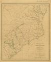
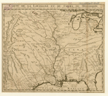
1089.
The seat of war of the revolution in the southern states; shewing the principal movements of the hostile armies. Philadelphia: [1822].
Cartographer:
H. S. Tanner.
Engraver:
H. S. Tanner.
|
[1822]. |
Scale: 1 in. = 30 mi.
Size: 45 x 38.4 cm.
Colored..
|
(650: [1822]: T158swr Small) |
|
See: William Johnson, Sketches of the life and correspondence of Major General Greene. Charleston: Miller:1822.
|
|
|
Great Lakes Area
|
|
|
|
|
1295.
Chart of the lights on the lake coast of the United States. Published by the order and under the direction of the U.S. Light House Board. Prepared at the office of the survey of the
northern and north western lakes under the supervision of Capt. Geo. G. Meade. N.p.: 1861.
Cartographer:
Geo. G. Meade.
|
1861. |
5 pieces.
Scale: 1:600,000.
Sizes: Various.
Colored.
|
(670: 1861: Un48Lhb Large) |
|
|
|
|
Illinois
|
|
|
|
|
1321.
A plan of the several villages in the Illinois country, with part of the River Mississippi &c. By Thos. Hutchins. [London: J. Almon: 1778].
Cartographer:
Thomas Hutchins.
|
[1778]. |
Scale: 1 in. = 10 mi.
Size: 18.1 x 12.9 cm.
|
(674: [1778]: H973vmr Small) |
|
See: A topographical description of Virginia, Pennsylvania, Maryland and North Carolina, by Thos. Hutchins. London: J. Almon: 1778.
|
|
|
Mississippi River
|
|
|
|
|
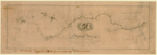
1330.
Map of the Mississippi River from its source to the mouth of the Missouri: laid down from the notes of Lieut. Z. M. Pike,
by Anthony Nav. Reduced, and corrected by the astronomical observations of Mr. Thompson at its source: and of Capt. M. Lewis,
where it receives the waters of the Missouri. [1807].
Cartographer:
Anthony Nav, Z. M. Pike, Mr. Thompson, and M. Lewis.
Engraver:
Francis Shallus.
|
[1807]. |
Scale: 1 in. = 25 mi.
Size: 23.5 x 77.5 cm.
|
(633: [1807]: K584mrm Large) |
|
See: Zebulon M. Pike's Account of a voyage up the Mississippi River. Washington: 1807, and Account of expeditions to the source of the Mississippi. Philadelphia: 1810.
Provenance:
Presented by Thomas Jefferson, 1807.
|
|
|
Central States
|
|
|
|
|
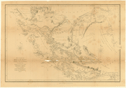
1374.
Carte de la Louisiane et du cours du Mississippi dressée sur un grand nombre de mémoires, entrau tres [sic] sur ceux de M.
de le Maire, par Guillaume de l'lsle de l'Académie R[oya]le des Sciences. [Paris?: ca. 1720].
Cartographer:
Guillaume de l'lsle.
|
[ca. 1720]. |
Size: 35.5m x 41.2 cm.
Colored.
|
(636: [ca. 1720]: D372Lt Small) |
|
Provenance:
Presented by Peter S. Du Ponceau, 15 January 1841.
|
|
|
Missouri
|
|
|
|
|
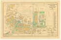
1385.
Ground plan [of the] Louisiana Purchase Exposition, St. Louis, Missouri. Worlds Fair. 1904. Issued by Brown Brothers & Company: New York, Philadelphia and Boston: Brown, Shipley & Company: London.
Brooklyn: 1904.
|
1904. |
Scale: 4 cm. = 1,000 ft.
Size: 27.9 x 45.1 cm.
Colored.
|
(679: 1904: H993Lou Small) |
|
|
|
|
South America
|
|
|
|
|
Chile
|
|
|
|
|
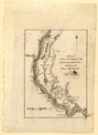
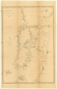
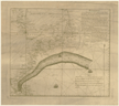
1575.
The Strait of Magalhaens, commonly called Magellan. Surveyed by the officers of His Majesty's Ships, Adventure and Beagle. Under the direction of Captains Phillip Parker King,
F.R.S., Pringle Stokes & Robert Fitz Roy. 1826-34. London: Henry Colburn: 1839.
Cartographer:
Phillip Parker King, Pringle Stokes, and Robert Fitz Roy.
Engraver:
J. Gardner.
|
1839. |
Size: 31.4 x 46.9 cm.
|
(782.669: 1839: K588abe Small) |
|
Removed from Narrative of the surveying voyages of His Majesty's ships Adventure and Beagle. . . London: 1839.
|
|
|
1577.
Chiloe and parts of the adjacent coasts from H.M.S. Beagle. 1835. London: Henry Colburn: 1839.
Engraver:
J. & C. Walker.
|
1839. |
Size: 46.6 x 31.8 cm.
|
(782: 1839: C435bea Small) |
|
Removed from Narrative of the surveying voyages of His Majesty's ships Adventure and Beagle . . . London: 1839.
|
|
|
Oceans - World
|
|
|
|
|
Pacific Ocean
|
|
|
|
|
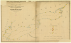
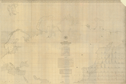
1618.
Maury's wind and current chart. Whale sheet No. 2. Series F. U.S. Hydrographical Office. N.p.: n.d.
Cartographer:
M. F. Maury.
|
n.d. |
Size: 59.8 x 90.6 cm.
Colored.
|
(900: n.d.: M444wcc Small) |
|
Contains part of the book plate of J. Peter Lesley.
|
|
|
Polynesia
|
|
|
|
|
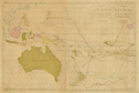
1619.
Carte de la Polynesie ou la cinquième partie de la terre [title also in Swedish]. Par Daniel Djurberg. Stockholm: 1780.
Cartographer:
Daniel Djurberg.
|
1780. |
Size: 47.5 x 71.8 cm.
Colored.
|
(940: 1780: D642ppt Large) |
|
Inset: Easter and S. Daniel Islands.
Shows tracks of Captain Cook, de Surville, Tasman, Roggewin, Wallis, Bougainville, Biron, Mendonna, Mendarina, La Maire, and
Carteret.
|
|
|
Atlantic Ocean
|
|
|
|
|
1622.
Remarques sur la navigation de Terre-Neuve à New-York afin d'éviter les Courrants et les bas-fonds au sud de Nantuckett et
du Banc de George. [Franklin's second chart of the Gulf Stream]. Paris: Le Rouge: [ca. 1785].
Cartographer:
Benjamin Franklin.
|
[ca. 1785]. |
Size: 31.7 x 36.2 cm.
|
(980: [ca. 1785]: F843sLn Small) |
|
See: Franklin Bache, "Where is Franklin's first chart of the Gulf Stream?" American Philosophical Society, Proceedings, vol. 76, p. 731, 1936; and Benjamin Franklin, "A letter from Dr. Benjamin Franklin to Mr. Alphonsus Le Roy . . . August
1785," American Philosophical Society, Transactions, vol. 2. Philadelphia: 1786.
|
|
|
Indian Ocean
|
|
|
|
|
1634.
Indischer Ocean. Commodore B. V. Wüllerstorf-Urbair, S. M. Fregatte Novara. 1857. [Vienna]: K.-K. Hof- u. Staats-Druckerei: [ca. 1860].
Cartographer:
B. V. Wüllerstorf-Urbair.
|
[ca. 1860]. |
7 maps.
Scales: Various.
Size of paper: Ca. 80 x 56.5 cm.
|
(990: [ca. 1860]: W957fno Large) |
|
|
|