|
|
|
|
|
|
|
|
|
|
|
|
|
|
|
|
|
Europe
|
|
|
|
|
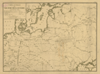
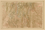
111.
Carte générale du théâtre de la guerre. Plate ler. N.p.: [ca. 1812].
|
[ca. 1812]. |
Scale: 25 French common leagues = 1 degree.
Size: 35.4 x 48.3 cm.
|
(204: [ca. 1812]: Eu72nap Small) |
|
|
|
|
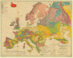
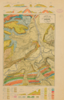
114.
Geological map of Europe executed under the direction of Joseph Prestwich, F.R.S. by William Topley, F.G.S., and J.G. Goodchild,
F.G.S. from the latest surveys. Edinburgh: W. and A. K. Johnston: [ca. 1860].
Cartographer:
William Topley and J. G. Goodchild.
Engraver:
W. and A. K. Johnston.
|
[ca. 1860]. |
Scale: 69 English statute mi. = 1 degree.
Size: 44.3 x 57.1 cm.
Colored.
|
(200: [ca. 1860]: P926geo Small) |
|
Printed for Prestwich's Geology, vol. 2, Clarendon Press.
See: Sir Joseph Prestwich, Geology chemical, physical, & statigraphical. Oxford: Clarendon Press: 1886-1888. 2 vols.
|
|
|
England and Wales
|
|
|
|
|
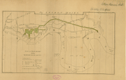
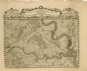
132.
London docks. Plan of the River Thames with the proposed docks and cut. London: 1794.
|
1794. |
Size: 27.8 x 50.6 cm.
Colored.
|
(216: 1794: L845doc Small) |
|
See: William Vaughan, Plan of the London dock . . ., 1794.
Provenance:
Provenance:Presented by William Vaughn
|
|
|
Ireland
|
|
|
|
|
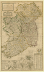
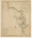
145.
A new map of Ireland divided into its provinces, counties and baronies, wherein are distinguished the bishopricks, borroughs,
barracks, bogs, passes, bridges &c. with the principal roads, and the common reputed miles. According to the newest and most
exact observations. By Herman Moll geographer. [London]: I. Bowles et al:. 1714.
Cartographer:
Herman Moll.
|
1714. |
Scale: 60 mi. of Great Britain = 1 degree.
Size: 102.5 x 61.7 cm.
Colored.
|
(211: 1714: M735bfi Large) |
|
Insets: maps of the British Isles; Isle of St. Patrick's purgatory; Waterford; Gyants Cawsway; Gallway; harbour of Kinsale; Limrick;
Dublin; and, Cork. Also, a catalogue of ye towns & places where barracks are erected . . .
This is a map of Ireland showing post roads travelled by Benjamin Franklin in 1771.
|
|
|
The Low Countries
|
|
|
|
|
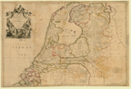
186.
The VII United Provinces. Corrected from the observations communicated to the Royal Society at London, and ye Royal Academy
at Paris.Humbly dedicated to Elihu Yale Esq. 1709.
Cartographer:
Ion. Senex and Ion. Maxwell.
Engraver:
John Senex.
|
1709. |
Scale: 2 cm. = 2 common English mi
Size: 63.8 x 94.1 cm.
Colored.
|
(232: 1709: Se57up Large) |
|
|
|
|
The Netherlands
|
|
|
|
|
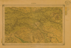
198.
Betuwe. 19. Ministerie van Oorlog. Topographisch Bureau. N.p.: [ca. 1865].
|
[ca. 1865]. |
Scale: 1:200,000.
Size: 28 x 43 cm.
Colored.
|
(232: [ca. 1865]: N386bet Small) |
|
Provenance:
Presented by the Minister of the Interior of the Netherlands.
|
|
|
Switzerland
|
|
|
|
|
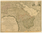
221.
La Turgovie avec le Lac de Constance, et des Pays Circonvoisins. Nova landgraviatus Turgoviae chorographica tabula, ubi Scaphusiensis,
Abbatisque Cellanae respublicae specialiter designatae proponuntur: nec non abbatia Sancti Galli, Episcopatus Constantinus,
Toggenburgensisque comitatus, cum omnibus insertis, et contiguis comitatibus Dominüs, et Confinibus; omnia ex probatissimis
subsidüs accuratissime et juxta limites delineata per Ioh. Ant. Rizzi Zannoni. Nürnberg: Homann: 1766.
Cartographer:
Giovanni Antonio Rizzi Zannoni.
|
1766. |
Size: 42 x 55.5 cm.
Colored.
|
(237: 1766: Z29cons Small) |
|
Damaged.
Provenance:
Presented by Ferdinand Rudolph Hassler, 20 March 1807.
|
|
|
235.
Die Eisgebyrge des Schweizerlandes, mit allen dabey vorkommenden Mineralien. In ihrem zusammenhang vorgestelt von G. S. Gruner. Paris: A. Zingg: [ca. 1800].
Cartographer:
G. S. Gruner.
|
[ca. 1800]. |
Size: 38.5 x 81 cm.
|
(237: [ca. 1800]: G923esm Large) |
|
Provenance:
Presented by Ferdinand Rudolph Hassler, 18 July 1808.
|
|
|
237.
Geologische Karte der Umgebung von Brugg (Aargau) von C. Moesch. Neuenburg: H. Furrer, litho.: [ca. 1861-1866].
Cartographer:
C. Moesch.
Engraver:
H. Furrer.
|
[ca. 1861-1866]. |
Scale: 1:25,000.
Size: 40.6 x 29 cm.
Colored.
|
(237: [ca. 1861-1866]: M715geo Small) |
|
Contains also profiles of certain elevations.
|
|
|
France
|
|
|
|
|
245.
Le pais de Brie. Guiljelmus Blaeu excudit. [Amsterdam: ca. 1644].
Cartographer:
W. J. Blaeu
|
[ca. 1644]. |
Scale: 8.1 cm. = 4 common Gallic mi.
Size: 39.1 x 49.8 cm.
|
(243.2: [ca. 1644]: B561fpb Small) |
|
|
|
|
253.
Tableau général des postes, l'année 1779. N.p.: n.d.
|
1779. |
Size: 45.9 x 41.5 cm.
|
(240: 1779: P847adp Small) |
|
Slightly mutilated.
Acquired with the Franklin-Bache purchase in 1936. This purchase greatly enhanced the Society's collection of Benjamin Franklin
manuscripts.
|
|
|
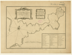
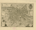
255.
Plan historique de la ville de Lyon et de ses quartiers, assujetti à ses accroissements embellissments, et projets. Paris: Moithey: 1786.
|
1786. |
Scale: 150 toises.
Size: 44.2 x 35.5 cm.
|
(248.949: 1786: M725fra Small) |
|
Provenance:
ProvenancePresented by William Short, 5 November 1824.
|
|
|
270.
Vues & coupes du Cap de la Hève. Profit du Cap. Le Havre: Lemercier: 1843.
Engraver:
Charles A. Lesueur.
|
1843. |
Size: 45.3 x 62.5 cm.
|
(242.1: 1843: L565vch Large) |
|
Provenance:
Presented by Charles A. Lesueur, 14 February 1845.
|
|
|
272.
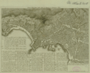
Monographic géologique des anciens glaciers et du terrain érratique de la partie moyenne du bassin du Rhône par A. Falsan
& E. Chantre. Lyon: Pitrat aîné: 1875. 6 maps in original wrappers.
Cartographer:
A. Falsan and E. Chantre.
|
1875. |
Size: 54.2 x 85 cm.
Colored.
|
(248: 1875: F183gLa Small) |
|
|
|
|
Central Europe
|
|
|
|
|
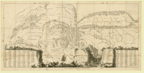
276.
[Lon]gitudinal section of the first 38 2/3 English miles of the railway for joining the [Mol]dau and the Danube . . . with
the Elbe, and the Black Sea with the northern ocean, by means of the continent, executed under the superintendence of [the
Ch]evalier Francis Anthony Gerstner. The [ac]t of the Emperor of Austria was . . . 1824, the work begun 28, July 1825 and
the 38 2/3 english miles were completely finished at the end of the year 1828. N.p.: [ca. 1830].
|
[ca. 1830]. |
5 sheets.
Size of paper: each ca. 59.5 x 72 cm.
|
(281: [ca. 1830]: L862mda Large) |
|
Insets: Transverse section of an excavation; A horse takes 3 waggons, each loaded with 2 or 2 ½ tons and goes with his load on a
level railway 20 English miles in one day; and Transverse section of an embankment, shewing the dry-walling in the middle.
Mutilated.
Provenance:
Presented by the Rev. Mr. Barry.
|
|
|
Germany
|
|
|
|
|
290.
Basis novae chartae Palatinae . . . By Christian Mayer. N.p.: January 1773.
Cartographer:
Christian Mayer.
Engraver:
E. Vevelst.
|
1773. |
2 copies.
Scale: Pariser toises, oder klaffter zu 6 schube.
Size: 21.5 x 32 cm.
|
(273: 1773: M455pal Small) |
|
The Society thanked Mayer "for his ingenious performances" and wished to have "the continuation of his valuable correspondence."
In return, the members promised that they "will esteem themselves happy in communicating anything in their power to assist
him in the Prosecution of his Philosophical Researches." [Minutes: Archives].
Provenance:
Presented by Christian Mayer, 15 December 1773.
|
|
|
Spain And Portugal
|
|
|
|
|
326.
Plan of the River Viguo, and Port de Rande. Situated in the north part of Spain, in the kingdom of Gallice . . . by Joseph Smith Speer. London: Speer: 1773 [14 June
1773].
Cartographer:
Speer.
Engraver:
Hall.
|
14 June 1773. |
Scale: 5 marine mi. 60 to a degree.
Size: 33 x 47 cm.
|
(341: 1773: Sp27vig Small) |
|
Provenance:
Presented by the Direccion de Hidrografia, Madrid, 19 October 1852.
|
|
|
329.
Ilha de Leão com asilhetas e fortes adjacentes ciudade e porto de Cadix com seus baixos &c. D. Vicente Tofino. [Lisbon?: ca. 1789].
Cartographer:
Vincente Tofino.
Engraver:
Queiroz.
|
[ca. 1789]. |
Scale: 69½ British statute mi. = 1 degree.
Size: 42.3 x 33.3 cm.
|
(346: [ca. 1789]: T578Leo Small) |
|
|
|
|
Italy
|
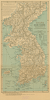
|
|
|
|
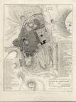
342.
Pianta topografica della città di Napoli in Campagna Felice. N.p.: V. A. P. Nicolaus Carletti: [ca. 1770].
Cartographer:
Nicolaus Carletti.
Engraver:
Philip Morghen, 1770.
|
[ca. 1770]. |
Size: 27.6 x 37.9 cm.
|
(363.956: [ca. 1770]: C212nap Small) |
|
Provenance:
Presented by William Short, 5 November 1824.
|
|
|
346.
Pianta della città di Firenze nelle sue vere misure; colla descrizione dei luoghi più notabili di ciascun quartiere. N.p.: 1784.
Engraver:
Giuseppe Poggiali.
|
1784. |
Size: 26.6 x 36 cm.
|
(350.932: 1784: P756fir Small) |
|
Provenance:
Presented by William Short, 5 November 1824.
|
|
|
357.
Carte de l'isle d'Elbe, dressée d'après les opérations trigonométriques extraites du traité de géodésie de Mr. Puissant. Par Ch[ar]les Picquet. Paris: 1814.
Cartographer:
Charles Picquet.
Engraver:
Alexandre Blondeau.
|
1814. |
Scale: 25 French common leagues = 1 degree.
Size: 37.8 x 50.7 cm.
|
(350: 1814: P586tri Small) |
|
Inset: Map of Porto-Ferrajo.
|
|
|
Asia
|
|
|
|
|
Near East
|
|
|
|
|
372.
Plan of Jerusalem by F. Catherwood, Architect, July, 1835. London: author: 1835.
Cartographer:
F. Catherwood.
Engraver:
S. Bellin.
|
1835. |
Scale: 2½ in. = 1,500 feet.
Size: 26.8 x 21.2 cm.
|
(414.944: 1835: C282jer Small) |
|
See "F. Catherwood architect," (in New-York Historical Society Quarterly, vol. 30, no. 1.)
|
|
|
Japan
|
|
|
|
|
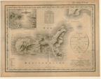
381.
Korea or Cho-sen of the Japanese. Compiled from the map published by the Japanese War Ministry, Tôkiô, in 1875, and from the latest coast surveys. Names transliterated
by Dr. Ernest Satow. Washington: Norris Peters Co.: [ca. 1895].
Cartographer:
Charles H. Ourand.
|
[ca. 1895]. |
Scale: 1:1,700,000.
Size: 53.1 x 28 cm.
Colored.
|
(433: [ca. 1895]: K844tok Small) |
|
Inset: Quelpart I[slan]d Ché-Ju of the Koreans.
|
|
|
China
|
|
|
|
|
388.
[Chinese maps of Canton and Hong Kong, China. Ca. 1820].
|
[ca. 1820]. |
Size of paper: 57.2 x 34.4 cm. Canton: 21.8 x 28.2 cm., and Hong Kong: 19.5 x 37.5 cm.
Colored.
|
(443: [ca. 1820]: C162kwa Small) |
|
Provenance:
Presented by Joshua L. Oakford, 8 November 1820.
|
|