|
|
|
|
|
|
|
|
|
|
|
|
|
|
|
|
|
Middle Atlantic States
|
|
|
|
|
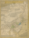
751.
A map of Pensilvania, New-Jersey, New-York, and the three Delaware counties: by Lewis Evans. MDCCXLIX. Published by Lewis Evans March 25, 1749 according to act of Parliament. [Philadelphia]: 1749.
Cartographer:
Lewis Evans.
Engraver:
L. Hebert.
|
1749. |
Scale: 69 English mi. = 1 degree.
Size: 64.4 x 49.1 cm.
Colored.
|
(640.2: 1749: Ev12tdc Large) |
|
Norris's copy has now disappeared. It was being used as late as 5 October 1832, for James Mease commented that there was a
marginal note by Evans that "all great storms begin at the leeward." Somehow, this note strengthened Mease's theory that the
present earth "was made at the creation from the ruins of another" (Minutes).
Wheat: 672
Contains comments about the origins of the northeast storms (suggested by B. Franklin?), lightning and electricity, navigation
of the Delaware River, and other bays, etc.
Endorsement on back, in Benjamin Franklin's hand: "To Dr. John Mitchell from Mr. B. Franklin." The map was at one time in
the collection of the Marquess of Bute, a friend of Mitchell's.
Provenance:
Joseph Parker Norris gave a copy of this map to the American Philosophical Society on 16 June 1815.
|
|
|
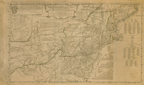
757.
A map of the middle British colonies in North America. First published by Mr. Lewis Evans, of Philadelphia, in 1755; and since corrected and improved, as also extended, with the
addition of New England and bordering parts of Canada; from actual surveys now lying at the Board of Trade. By T. Pownall.
London: J. Almon: 1776 [25 March 1776].
Cartographer:
Lewis Evans and T. Pownall.
Engraver:
James Turner.
|
[25 March 1776]. |
Scale: 7 cm. = 90 mi.
Size: 49.3 x 82.4 cm.
Colored.
|
(635: 1776: P876bc Large) |
|
Inset: A sketch of the remaining part of Ohio R. &c.
|
|
|
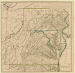
759.
A map of the country between Albermarle Sound and Lake Erie, comprehending the whole of Virginia, Maryland, Delaware and Pennsylvania,
with parts of several other of the United States of America. Engraved for the Notes on Virginia. The country on the eastern side of the Allegany Mountains, is taken from Fry and Jefferson's
map of Virginia, and Scull's map of Pennsylvania, which were constructed chiefly on actual survey; that on the western side
of the Alleganey, is taken from Hutchins, who went over the principal water courses, with a compass and log-line, correcting
his work by observations of latitude; additions have been made, where they could be made on sure ground. [Paris: 1786].
Cartographer:
Fry, Jefferson, Scull, and Hutchins.
Engraver:
S. J. Neele.
|
[1786]. |
Size: 59.9 x 59.6 cm.
Colored.
|
(917.55: J35) |
|
The Society asked Thomas Jefferson in 1805 for a copy of his Notes on Virginia. Jefferson wrote 2 May 1805 and presented "a single copy remaining of the original edition printed at Paris, the only one
almost perfectly correct, & was never sold, a few copies only having been printed and given to my friends" (Archives).
In: Thomas Jefferson, Notes on Virginia.
|
|
|
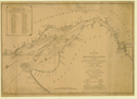
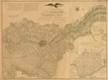
762.
A chart of Delaware Bay and River, containing a full and exact description of the shores, creeks, harbours, soundings, shoals,
sands and bearings of the most considerable land marks, &c. &c. Faithfully copied from that published at Philadelphia. By Joshua Fisher, together with the tide table from the capes to Philadelphia
. . . London: Laurie and Whittle: 1794 [12 May 1794].
Cartographer:
Joshua Fisher.
|
[12 May 1794]. |
Scale: 69½ English mi. = 1 degree.
Size: 46.8 x 68.6 cm.
|
(640.2: 1794: F533db Large) |
|
Original in North American pilot. . . London: Laurie and Whittle: 1800. No. 10.
|
|
|
New York
|
|
|
|
|
New York City
|
|
|
|
|
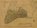
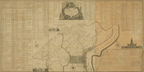
845.
Plan of the city of New York. Drawn and engrav'd for D. Longworth, map and print seller. [New York]: D. Longworth: [ca. 1830].
Cartographer:
J .A.
Engraver:
P. R. Maverick.
|
[ca. 1830]. |
Scale: 1 in. = 1000 ft.
Szie: 37.9 x 55 cm.
|
(647.957: [ca. 1830]: M455pny Small) |
|
Provenance:
Presented by Daniel Parker, 4 January 1833.
|
|
|
Pennsylvania
|
|
|
|
|
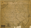
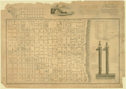
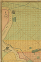
913.
A map exhibiting a general view of the roads and inland navigation of Pennsylvania, and part of the adjacent states. By John Adlum and John Wallis. N.p.: [ca. 1791].
Cartographer:
John Adlum and John Wallis.
|
[ca. 1791]. |
Scale: 1 degree = 69 mi.
Size: 84.1 x 93.5 cm.
Colored.
|
(649: [ca. 1791]: Ad11grn Large) |
|
Inset: Perspective view of part of a canal with locks.
Mutilated.
Wheat: 432
|
|
|
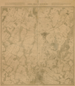
950.
Battle field of Gettysburg. U.S. Corps of Engineers. Survey ordered by Brevet Major General A. A. Humphreys . . . and conducted under Brevet Major General
G. K. Warren. [Washington: ca. 1865].
Cartographer:
G. K. Warren and A. A. Humphreys.
|
[ca. 1865]. |
Scale: 1:12,000.
Size: 73.4 x 69.9 cm.
|
(649.934: [ca. 1865]: Un38gfb Large) |
|
Map reduced from one on a scale of 1 in. = 200 ft., deposited in the archives of the Chief of Engineers.
|
|
|
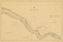
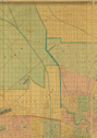
957.
Delaware River from Cherry Island flats to Bridesburg. U.S. Coast and Geodetic Survey. J. E. Hilgard, superintendent. [Washington]: 1882.
Cartographer:
S. C. McCorkle, R. M. Bache, C. T. Iardella, H. L. Marindin, H. B. Mansfield, and J. E. Hilgard.
|
1882. |
Scale: 1:40,000.
Size: 68.7 x 106.4 cm.
|
(649: 1882: Un38cfb Large) |
|
Note: Preliminary edition by photo-lithography, to be superceded eventually by an engraved edition.
Provenance:
Presented by U.S. Coast and Geodetic Survey through Spencer C. McCorkle, 14 December 1885.
|
|
|
Philadelphia
|
|
|
|
|
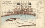
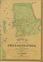
990.
. . .Map of the city and liberties of Philadelphia, with the catalogue of purchasers, is humbly dedicated by their most obedient
humble servant, John Reed. [Philadelphia]: T. Man: [1774].
Cartographer:
John Reed.
Engraver:
James Smither.
|
[1774]. |
Scale: 1 in. = 100 perches.
Size: 75.4 x 150.5 cm.
|
(649.962: 1774: R257cLp Large) |
|
Inset: Philadelphia; vignettes of the State House, Pennsylvania Hospital, and the house of employment and the alms house.
See: John Reed, An explanation of the city and liberties of Philadelphia. Philadelphia: 1774.
Wheat: 457
|
|
|
994.
Philadelphie, par Eas[t]burn. Paris: Le Rouge: [ca. 1777].
Cartographer:
B. Eastburn.
|
[ca. 1777]. |
Scale: 1 in. = 900 English ft.
Size: 21.2 x 35.1 cm.
Colored.
|
(649.962: [ca. 1777]: Ea82ppp Small) |
|
|
|
|
1003.
Plan of the city of Philadelphia and environs. Surveyed by John Hills in the summers of 1801, 2, 3, 4, 5, 6, & 7. Philadelphia: John Hills: 1808.
Cartographer:
John Hills.
Engraver:
William Kneass.
|
1808. |
Scale: Distance between the circles is one mile.
Size: 100.6 x 100.6 cm. In 10 circles, outermost circle 99 cm. diameter.
|
(649.962: 1808: H553cmp Large) |
|
Contains engravings of the Philadelphia Water Works and Cape Henlopen lighthouse.
|
|
|
1005.
This new map of the city of Philadelphia for the use of fire men and others is most respectfully dedicated to the citizens
and members of the engine & hose companies, by . . . John A. Paxton. [Philadelphia: ca. 1816].
Cartographer:
W. Strickland.
|
[ca. 1816]. |
Size: 35.4 x 61.2 cm.
Size of paper: 47.5 x 61.2 cm.
|
(649.962: [ca. 1816]: P286feh Large) |
|
Contains: a listing of engine & hose houses; a vignette of the Fair Mount Water Works; an extension of the northwestern end
of the map of the city to include Fair Mount; and cut away diagrams of two fire plugs.
|
|
|
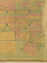
1006.
Map of Philadelphia County, constructed by virtue of an act of the legislature of Pennsylvania. By John Melish. 1816. Philadelphia: Melish: 1819 [14 April 1819].
Cartographer:
J. Melish.
Engraver:
Tanner, Vallance, Kearny, & Company.
|
[14 April 1819]. |
Scale: 1 in. = 1¼ mi.
Size: 43.4 x 49 cm.
Colored.
|
(649.762: 1819: M485pc Small) |
|
|
|
|
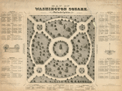
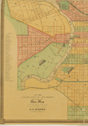
1012.
Map of Washington Square, Walnut Street, Philadelphia. [Philadelphia]: M. Schmitz & P. Kereven: 1843.
Cartographer:
John B. Colahan and M. Schmitz.
Engraver:
T. Sinclair.
|
[1843]. |
Scale: 1 in. = 30 ft.
Size: 47 x 47 cm.
Size of paper: 63.4 x 85.6 cm.
|
(649.962: [1843]: Sch17ws Large) |
|
The botanical and English names of the trees on this map were collected with great care, and their position given by Patrick
Kereven, chief gardener of Wash[i]ng[ton] & Indepen[den]ce Squares.
Provenance:
Presented by Thomas Sinclair, 26 May 1843.
|
|
|
1014.
Map of the city of Philadelphia, together with all the surrounding districts, including Camden, N. J., from official records,
plans of the district surveyor & original surveys by J. C. Sydney. 1849. Philadelphia: Smith & Wistar: 1849.
Cartographer:
J. C. Sydney.
Engraver:
P. S. Duval.
|
1849. |
Scale: 1 in. = 450 ft.
Size: 171 x 173.5 cm.
Colored.
|
(649.962: 1849: Si17phL Large) |
|
Provenance:
Presented 12 July 1849.
|
|
|
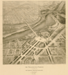
1028.
The Philadelphia Parkway as planned for the Fairmount Park Association. Horace Trumbauer, C. C. Zantzinger, and Paul P. Cret. [Philadelphia: 1908].
Cartographer:
Horace Trumbauer, C. C. Zantzinger, and Paul P. Cret.
|
[1908]. |
Size: 66.7 x 66.7 cm.
|
(649.962: [1908]: T778ppf Large) |
|
See: Philadelphia Fairmount Park Art Association, Report of the Commission. . . . Philadelphia: 1908.
|
|
|
Maryland
|
|
|
|
|
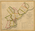
1068.
A map of the head of Chesapeake Bay and Susquehanna River. Shewing the navigation of the same with a topographical description of the surrounding country from an actual survey. By
C. P. Hauducoeur. N.p.: 1799.
Cartographer:
C. P. Hauducoeur.
Engraver:
Allardice.
|
1799. |
Scale: 1:250 poles.
Size: 55.9 x 75 cm.
|
(652: 1799: H293cbs large) |
|
Inset: Plan of the town of Havre de Grace.
Wheat: 520
|
|
|
District Of Columbia
|
|
|
|
|
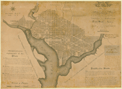
1078.
Plan of the city of Washington in the territory of Columbia, ceded by the states of Virginia and Maryland to the United States
of America, and by them established as the seat of their government, after the year MDCCC. Philadelphia: 1792.
Cartographer:
James Thackara.
Engraver:
Thackara and Vallance.
|
1792. |
Scale: 1 in. = 100 poles.
Size of paper: ca. 51.5 x 71.5 cm.
|
(653: 1792: T328pcw Large) |
|
Contains autograph of Washington.
Wheat: 531
Provenance:
Presented by George Washington to the Earl of Buchan, 22 April 1793; subsequently by Buchan to the American Philosophical
Society, 17 July 1793.
|
|