|
|
|
|
|
|
|
|
|
|
|
|
|
|
|
|
|
North America
|
|
|
|
|
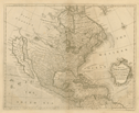
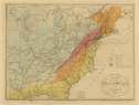
450.
A map of North America with the European settlements & whatever else is remarkable in ye West Indies, from the latest and
best observations. [London: ca. 1744].
Engraver:
R. W. Seale.
|
ca. 1744. |
Size: 37.5 x 47 cm.
|
(600: [ca. 1744]: Se17nae Small) |
|
See: Paul Rapin de Thoyas, The history of England. Continued by N. Tindal. London: 1744: vol. 3.
|
|
|
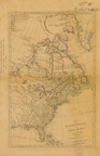
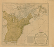
453.
A map of the British Empire in North America; by Samuel Dunn. London: Robert Sayer: 1774 [10 January 1774].
Cartographer:
Samuel Dunn.
|
10 January 1774. |
Scale: 69½ English mi. = 1 degree.
Size: 47 x 30.4 cm.
Colored.
|
(601: 1774: D912bna Large) |
|
Former Secretary of the Treasury, Albert Gallatin, wrote 7 November 1828 requesting the loan of particular maps for use in
settling the Northeast Boundary Dispute with Great Britain. Secretary John Vaughan acquired some for him from Samuel Hazard
and the "City Library," as well as some from the Society's library. Gallatin wrote that "in every case where we have but one
engraved copy of a Map, we are bound to deliver a manuscript copy to the British Minister here on 1st of January next." He
stated that the map he wanted more than any other, is in truth the same map, but bearing on the face of it the date of 1776 to 1782 (or 1777 I believe) and not having the word "United States" on it or in it. The title is in substance as follows vizt:
A new and correct map of North America with the West Indian Islands, divided according to the last treaty of peace concluded
at Paris 10th February 1763, corrected from the original materials of Govr. Pownal M.P. Sayer & Bennet 1777. But it may vary a little in the said title & been any date from 1775 to 1782 [Archives].
Vaughan shipped the maps 16 November, and Gallatin retained two which belonged to the Society [22 November 1828, Archives].
As "U.S. Agent for the N.E. boundary," he signed for these two on 26 December: "Sayer & Bennett's U.States-Feby 1783" and
"Dunn's British Empire 1774." They were to be "laid before the Arbiter" and they would be "returned, replaced, or, in case
of unavoidable accident, compensated for by the United States" [Archives, Receipt]. He returned the unused maps 2 January
1829 and sent his "thanks and those of the Government for your zealous and useful services on this important occasion" [Archives].
These maps were not returned by 1843 so the members instructed Secretary George Ord on 15 December to recover them. Ord wrote
immediately to Gallatin who replied 19 December, explaining what happened to them:
Sayer & Bennet's United States, delivered to the British Minister at Washington, as part of the evidence to be laid before the Arbiter and which, in conformity
with the Convention, the U. States were bound to communicate to the British Government on the 31st Dec[emb]er 1828. - cannot
be recovered. Dunn's British Empire, laid before the Arbiter. All the maps laid before the King of Holland were bound together at Washington. That Atlas was,
I understand, brought back from Holland by Mr. Treble and must be in the Department of State [Archives].
On 18 May 1852, Acting Secretary of State William Hunter returned the Sayer and Bennett map. It had been found "this morning"
and Hunter hastened "to restore it to your Society" [Archives].
The Dunn map was returned 15 December 1852 by Secretary of State Edward Everett. He wrote member C. B. Trego that the map
was returned by direction of the President "with the thanks of this Department for its use" [Archives].
For the Sayer and Bennett map, see: No. 550.
|
|
|
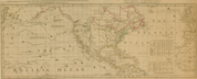
456.
North America and the West Indies, with the opposite coasts of Europe and Africa. Chart, containing the coasts of California, New Albion, and Russian discoveries to the north; with the peninsula of Kamtschatka,
in Asia, opposite thereto; and islands, dispersed over the Pacific Ocean, to the north of the line. London: Robert Sayer:
1787 [10 November 1787].
|
10 November 1787. |
Size of plate: 45.3 x 113 cm.
Colored.
|
(130: 1787: Sa97naw Small) |
|
Shows routes of early navigators.
|
|
|
Canada
|
|
|
|
|
Eastern Canada
|
|
|
|
|
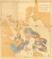
486.
The Eskimo tribes of north-east America. By Franz Boas. [New York]: Julius Bien & Co. Lith.: [ca. 1888].
Cartographer:
Franz Boas.
Engraver:
Julius Bien & Co.
|
[ca. 1888]. |
Size: 19⅜ in. x 17 3/16 in.
Colored.
|
(610: [ca. 1888]: B638etr Small) |
|
See: U.S. Bureau of American Ethnology. Franz Boas, "The Central Eskimo."Sixth Annual Report.
Provenance:
Presented by Mrs. Helene Boas Yampolsky, 1961-1962.
|
|
|
United States Of America
|
|
|
|
|
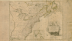
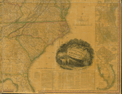
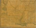
550.
The United States of America with the British possessions of Canada, Nova Scotia, & of Newfoundland, divided with the French;
and the Spanish territories of Louisiana and Florida according to the preliminary articles of peace signed at Versailles the
20th of Jan[uar]y 1783. London: R. Sayer & J. Bennett: 1783 [9 February 1783].
Cartographer:
T. Jeffery.
|
9 February 1783. |
Scale: 69½ English mi. = 1 degree.
Size: 46.1 x 51.3 cm.
Colored.
|
(635: 1783: Un38cns Large) |
|
Originally in T. Jefferys, The American atlas. London: Sayer and Bennett: 1782.
Loaned to the U.S. Government in 1828 for use during the Northeast Boundary dispute with Great Britain. For story, see No.
453.
|
|
|
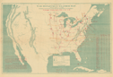
551.
Carte des États-Unis de l'Amérique suivant le traité de paix de 1783. Dédiée et présentée à, S. Excellence Mr. Benjamin Franklin
ministre plenipotentiare des États-Unis de l'Amérique près la Cour de France, anc. présid. de la conventiõ de Pensilvanie
et de la société philosophique de Philadelphia, &c. &c. Par son très humble et très obeissant serviteur Lattré. 1784. Paris: Lattré: 1784.
Cartographer:
Lattré.
|
1784. |
Scale: 70 English mi. = 1 degree.
Size: 54 x 75.6 cm.
Size of paper: 56.9 x 101.7 cm.
Colored.
|
(635: 1784: L355eua Large) |
|
Inset: Supplément à la Floride.
On the right and left sides of the map are: Principaux événemens militaires entre les Américains et les Anglois.
The Society also owns a reproduction of this map taken from the copy in the Newberry Library.
|
|
|
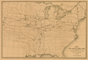
555.
A map of the United States, exhibiting the post-roads, the situations, connections & distances of the post-offices stage roads,
counties, ports of entry and delivery for foreign vessels, and the principal rivers. By Abraham Bradley, Junr.
Cartographer:
Abraham Bradley, Jr.
Engraver:
William Harrison, Jr.
|
[1796]. |
Scale: 1 cm. = 15 mi.
Size of paper: 89 x 94.4 cm.
|
(635: [1796]: B721usp Large) |
|
Inset: Progress of the mail on the main line.
Wheat: 128
|
|
|
567.
A map historical and biographical chart. Of the United States by David Ramsay. [Philadelphia: Carey: ca. 1815].
Cartographer:
David Ramsay.
|
[ca. 1815]. |
Size: 31.5 x 35.3 cm.
Size of paper: 48.2 x 73.8 cm.
Colored.
|
(635: [ca. 1815]: R147hbc Large) |
|
Contains map and chart with four columns of text.
See: Robert L. Brunhouse, "David Ramsey, selections from his writings." American Philosophical Society. Transactions, n.s., vol. 55.
|
|
|
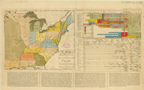
570.
Map of the United States of America. Designed to illustrate the geological memoir of William Maclure, Esqr. Entered as the Act directs, and published by John
Melish, Philadelphia [ca. 1818].
Cartographer:
William Maclure.
|
[ca. 1818]. |
Scale: 1 in. = 90 mi.
Size: 33 x 44.3 cm.
Colored.
|
(630: [ca. 1818]: Un38geo Small) |
|
Published in the Transactions of the American Philosophical Society, vol. 1, n.s., to illustrate William Maclure's geological observations, as read to
the Society, 16 May 1817.
Map shows proposed canals, boundary lines, and roads and distances.
|
|
|
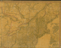
576.
United States of America. Philadelphia: H. S. Tanner: 1829.
Cartographer:
H. S. Tanner.
|
1829. |
Size: 117.7 x 151.3 cm.
|
(630: 1829: T158moe Large) |
|
Insets: South part of Florida, and, Oregon and Mandan district. Individual insets of Washington, Baltimore, Philadelphia, New York,
Boston, Charleston and New Orleans: environs of Albany, Boston, New York, Philadelphia and Trenton, Baltimore and Washington,
and Savannah. Also, profiles of the following canals: Erie, Ohio, Morris (N. J.), Union, Chesapeake and Ohio. Also, profile
of Schuylkill navigation, Penna., and the Columbia railroad.
Provenance:
Presented by Henry Schenck Tanner, 18 September 1829.
|
|
|
585.
Weather map. U.S. War Department. Signal Service, U.S. Army. Division of Telegrams and Reports for the Benefit of Commerce. Washington:
J. L. Kervand, lith.: 1872.
Engraver:
J. L. Kervand.
|
1872. |
Size: 36.5 x 56.8 cm.
Colored.
|
(630: 1872: Un42wem Small) |
|
Three copies for Friday, 31 May 1872: 7:35 A.M.; 4:35 P.M.; and 11:35 P.M.
There are also yellow flimsies filled-in in manuscript.
|
|
|
591.
Map showing the rail road and canal lines used in the determination of elevations by James T. Gardner, geographer. [Ca. 1885].
Cartographer:
James T. Gardner.
|
[ca. 1885]. |
Size: 38 x 56.1 cm.
|
(630: [ca. 1885]: G173rrc Small) |
|
|
|
|
Northeastern United States And Canada
|
|
|
|
|
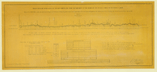
631.
Profile with the spirit level, of the due north line from the monument at the source of the River St. Croix to the St. John,
surveyed in 1840 & 1841 under the direction of Major J. D. Graham . . . one of the commissioners for surveying and exploring
the N. E. boundary of the U.S. U.S. Topographical Engineers. Washington: Hass lith.: [1841].
Cartographer:
J. D. Graham and Wilson McC. Fairfax.
Engraver:
P. Haas.
|
[1840/41]. |
Scale: 1 in. = 3 mi.
Horizontal scale of feet: 1:200,000.
Size: 32.2 x 76.4 cm.
|
(641: [1840/41]: Un 38scj Large) |
|
In presenting this document, I beg to call the attention of the Society to the strong contrast, which will appear on a comparison,
between the aspect of the country traversed by this due north line as there developed, and that exhibited by the profile of
Colonel Bouchette, the British surveyor under the 5th article of the Treaty of Ghent, derived from his surveys of that line
and his barometric measurements upon it in the years 1817 & '18.
The direction of the meridian line whose profile or vertical section is now offered to the notice of the Society, was obtained
from numerous astronomical observations, fully verified, with a transit instrument having a telescope of 43 inches focal length.
It will be perceived on reference thereto that the meridian, thus traced, does not meet with any highland or elevation whatever
in passing Mars Hill, but on the contrary that it passes the base of that eminence considerably to the eastward, and at a
depression nowhere less that 12 feet below the level of the base of the monument which was erected to mark the source of the River St.
Croix. . . . It may be well to remark that the base of this monument is surrounded (unless at seasons of extreme drought)
by the water constituting the extreme source of that river [Archives. J. D. Graham to APS, 28 March 1844. Minutes. Proc , vol. 4, p. 53. Donation Book].
Librarian George Ord was notified 22 June 1844 that W. R. Palmer had received these maps for the Society [Archives. W. R.
Palmer to G. Ord, 22 June 1844].
See: U.S. Congress, 27th, 3rd session. House of Representatives.
Provenance:
Presented by J. D. Graham, 19 July 1844. Major Graham wrote 28 March 1844 that he was presenting a profile or vertical
Section with the Spirit level, of the country traversed by the due north line from the monument at the source of the river
St. Croix, to the river St. John, derived from surveys executed under my direction in the years 1840 & 1841.
|
|
|
Massachusetts
|
|
|
|
|
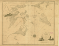
675.
Chart of the harbors of Salem, Marblehead, Beverly and Manchester. From a survey taken in the years 1804, 5 & 6 by Nath[anie]l Bowditch . . . assisted by Geo. Burchmore & Wm. Ropes 3rd. N.p.:
1806 [27 June 1806].
Cartographer:
Nathaniel Bowditch, George Burchmore, and William Ropes III.
Engraver:
Hooker & Fairman.
|
[27 June 1806]. |
Scale: 2 in. = 1¼ statute mi.
Size: 54.1 x 65.2 cm.
|
(644: 1806: B672smb Large) |
|
Provenance:
Presented and endorsed by Nathaniel Bowditch, 20 October 1809.
|
|
|
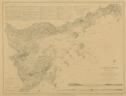
677.
Survey across the Isthmus of Cape Cod state of Massachusetts and town of Sandwich of a proposed canal between Buzzard's and
Barnstable bays. 1825. Surveyed by the U.S. Army Corps of Topographical Engineers under the direction of Major Per[r]ault. [Washington]: 1825.
Cartographer:
Major Perrault, Frederick Searle, W. B. Thompson, and John Farley.
|
1825. |
3 sheets.
Scale: 1 in. = 880 yd.
|
(644: 1825: Un31bb Small) |
|
No. 1. Survey across isthmus. 26.4 x 47.4 cm. No. 2. Profile of proposed route. 27.5 x 46.7 cm. No. 3. Survey of a valley
& ponds. 20.8 x 35.8 cm.
Provenance:
Presented by General Daniel Parker, 1 January 1833.
|
|
|
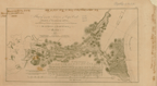
693.
Salem harbor, Massachusetts. From a trigonometrical survey under the direction of A. D. Bache. U.S. Coast and Geodetic Survey. [Washington]: 1855.
Cartographer:
A. D. Bache, C. O. Boutelle, H. L. Whiting, C. H. McBlair, C. Mahon, and C. Farquahar.
Engraver:
F. Danksworth, H. M. Knight, J. Knight, S. E. Stull, and J. Young.
|
1855. |
Scale: 1:25,000.
Size: 52.7 x 70.3 cm.
|
(644: 1855: Un38shm Large) |
|
Provenance:
Presented by the U.S. Treasury Department through A. D. Bache, 6 March 1857.
|
|
|
Boston
|
|
|
|
|
699.
Plan of Boston in New England with its environs, including Milton, Dorchester, Roxbury, Brookline, Cambridge, Medford, Charlestown,
parts of Malden and Chelsea. With the military works constructed in those places in the years 1775 and 1776. [Signed] : Henry Pelham. London: 1777 [2
June 1777].
Cartographer:
Henry Pelham.
Engraver:
Francis Jukes.
|
[2 June 1777]. |
Scale: 1:50,000.
Size: 99.3 x 69.3 cm.
|
(644.917: 1777: P366bne Large) |
|
Provenance:
Presented by Edward Hudson, 5 January 1827.
|
|